Vimy Lake Uplands Conservation Reserve Management Statement
This document provides policy direction for the protection, development and management of the Vimy Lake Uplands Conservation Reserve and its resources.
Statement of Conservation Interest
January, 2005
Approval statement
I am pleased to approve this Statement of Conservation Interest (SCI) for the Vimy Lake Uplands Conservation Reserve (C1565).
Direction for establishing, planning and managing conservation reserves is defined under the Public Lands Act and the Crown Land Use Policy Atlas. "Ontario’s network of natural heritage areas has been established to protect and conserve areas representative of the diversity of the natural regions of the province, including species, habitats, features and ecological systems which comprise that natural diversity." (Policy 3.03.05 for Conservation Reserves, OMNR 1997).
This basic SCI will provide guidance for the management of the conservation reserve and the basis for the ongoing monitoring of activities. More detailed direction at this time is not anticipated. Should significant facility development be considered or complex issues arise requiring additional studies, more defined management direction, such as a conservation reserve Resource Management Plan (RMP), may be developed.
This SCI was been reviewed by staff specialists at both the district and regional level of the Ministry of Natural Resources. The public was consulted prior to the regulation of Vimy Lake Uplands Conservation Reserve and prior to the approval of this SCI. Comments and concerns registered then are reflected in this Statement of Conservation Interest.
The Vimy Lake Uplands Conservation Reserve will be managed under the jurisdiction of the Area East Supervisor of the Ministry of Natural Resources, Chapleau District.
Submitted by:
Toni Armonas
Plan Author
Date: Original signed on Thursday February 17th, 2005
Recommended for Approval by:
Bob Johnston
District Manager
Date: Original signed on Tuesday February 22nd, 2005
Approved by:
Rob Galloway
Regional Director
Northeast Region
Date: Original signed on Tuesday April 5th, 2005
1.0 Introduction
The Province of Ontario is home to a broad range of climate types, geography, and plant and animal species, all of which contribute to the variety and abundance of natural resources found here. The Ministry of Natural Resources (OMNR) is the lead conservation and resource management agency in the province and is therefore responsible for the management of these resources, in particular, forests, fisheries, wildlife, mineral aggregates and petroleum resources, Crown lands and waters, and provincial parks and protected areas (OMNR Beyond 2000).
The Ministry of Natural Resources is committed to the protection of natural and cultural heritage values and, as such, has developed strategies that will maintain the integrity and sustainability of the parks and protected areas system.
Recently, the Government of Ontario conducted a major land use planning exercise which resulted in the release of the Ontario’s Living Legacy Land Use Strategy (1999). The Land Use Strategy focuses on four specific objectives that were established to guide the planning process. These are:
- to complete Ontario’s system of parks and protected areas
- to recognize the land use needs of the resource-based tourism industry
- to provide forestry, mining, and other resource industries with greater land and resource use certainty; and
- to enhance hunting, angling and other Crown land recreation opportunities
Ontario’s network of natural heritage areas has been established to protect and conserve areas that represent the diversity of the natural regions of the province, including the species, habitats, special features and ecological systems which comprise that natural diversity. Protecting these natural heritage areas is essential to the sustainable management of natural resources. It ensures that representative sites are retained in their natural state and can continue to contribute to Ontario’s natural environment.
In order to preserve these sensitive areas, they require protection from incompatible uses to ensure their values will endure over time. The creation of conservation reserves has been identified as a way of providing necessary protection from incompatible uses while still permitting many of the traditional uses that allow the people of Ontario to enjoy our special heritage.
Conservation reserves complement provincial parks in protecting representative natural areas and special landscapes. Most recreational (e.g. hiking, skiing, tourism related uses and nature appreciation) activities that have traditionally been enjoyed in the area will continue, provided that these uses do not impact on the natural features needing protection. The management and administration of a conservation reserve is guided by an approved Statement of Conservation Interest (SCI) or a resource management plan (RMP) if the conservation reserve has many complex issues.
An approved Statement of Conservation Interest is the minimum level of management direction established for a conservation reserve. The Statement of Conservation Interest defines the area that is being planned and the purpose for which the conservation reserve has been established. In addition, it provides management direction that will protect its natural and cultural heritage values and demonstrate its compatibility within the larger landscape. In addition, to ensure OMNR protection objectives are being fully met within the conservation reserve the surrounding landscape and related activities must consider the site’s objectives and heritage values. Finally, it is the intent of this SCI to create a public awareness that will promote responsible stewardship of the protected area and surrounding lands.
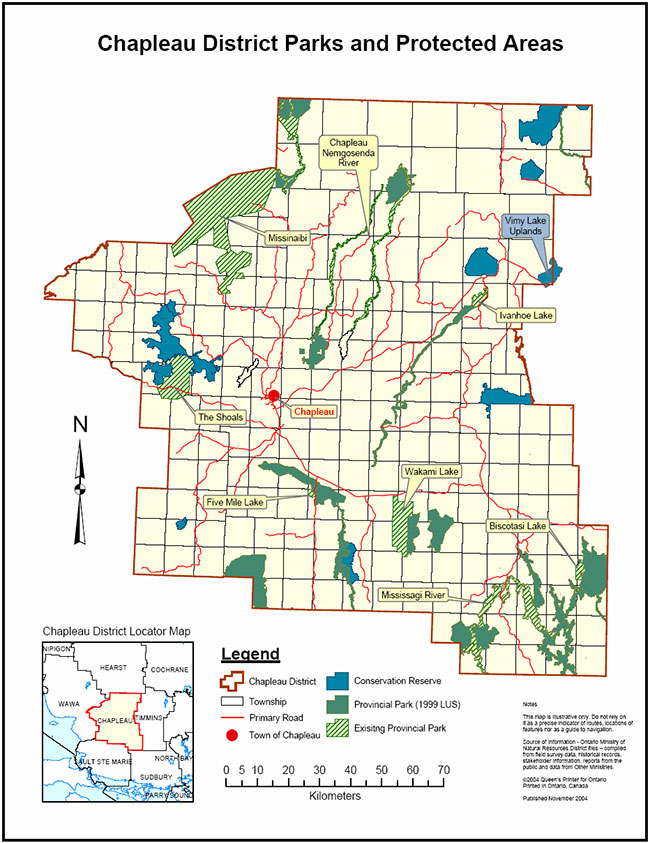
The Vimy Lake Uplands Conservation Reserve is composed entirely of Crown lands and waters. This 3,432 hectare conservation reserve is in the final stages of regulation and is located directly east of Foleyet, Ontario along Highway 101. The guidelines for the management of this conservation reserve are found in this document.
2.0 Goal and objectives
2.1 Goal of the SCI
The goal of the Vimy Lake Uplands Conservation Reserve as stated in Policy PL 3.03.05 for Conservation Reserves, (OMNR, 1997) is to protect natural and cultural heritage values on public lands while permitting compatible land use activities. The goal of this Statement of Conservation Interest is to provide the framework and direction to guide management decisions to ensure that the conservation reserve will meet this goal through both short and long term objectives.
2.2 Objectives of the SCI
2.2.1 Short term objectives
In order to ensure that the goal of this conservation reserve is met, the following short term objectives for this SCI have been identified:
- Identify the state of the resource with respect to natural heritage values and current land use activities for the conservation reserve
- Manage the conservation reserve to protect the integrity of its natural values via specific guidelines, strategies and prescriptions detailed in this plan
This Statement of Conservation Interest meets the planning requirement for conservation reserves as determined in Procedure PL 3.03.05 for Conservation Reserves which states that management plans must be written within three years of the regulation date (OMNR, 1997).
2.2.2 Long term objectives
In addition to the short term objectives mentioned above, long terms objectives will assist in ensuring the goal of this conservation is met. The long-term objectives for this SCI are:
- To establish representative targets and validate the site as a potential scientific benchmark
- To identify research/client services and marketing strategies
- To provide direction to evaluate future uses or economic ventures
3.0 Management planning
3.1 Planning context
3.1.1 Planning area
The planning area will consist of the regulated boundary for the Vimy Lake Uplands Conservation Reserve as defined in section 4.1.3 Administrative Description, and illustrated in map 8.1. This landbase will form the area directly influenced by this Statement of Conservation Interest. The plan will recognize the protection of values within the planning area, however, to fully protect values within the conservation reserve additional consideration within larger land use or resource management plans may be required. Any strategies noted within this plan related to the site’s boundary or beyond will need to be presented for consideration within a larger planning context. The Ministry of Natural Resources in conjunction with other partners will work to ensure that the values are protected during planning and implementation of activities on the surrounding landbase.
3.1.2 Management planning context
The need to complete the parks and protected areas system has long been recognized as an important component of ecological sustainability. This was reaffirmed in 1997 when the Lands for Life planning process was announced. Previous gap analysis studies were used to determine proposed candidate areas that would protect additional representative features and other significant values. The Vimy Lake Uplands Conservation Reserve was chosen as one of the candidate areas and subsequently appeared in the Ontario’s Living Legacy Land Use Strategy as C1565. Following consultations with the public, local aboriginal communities and affected industries during the summer of 2003, the boundary was finalized and approved by the Ministry of Natural Resources.
Conservation reserves cannot be used for mining, commercial forest harvest, hydro-electric power development, the extraction of aggregates and peat or other industrial purposes. Most recreational and non-industrial resource uses that have traditionally been enjoyed will be permitted to continue provided that they pose no threat to the natural ecosystems and identified values of the conservation reserve.
Permitted uses in conservation reserves will generally follow the direction expressed in the Land Use Strategy as well as any prior commitments that have been made by the Ministry of Natural Resources, Chapleau District office. For specific permitted uses pertaining to this conservation reserve, please see Appendix 9.2. Future uses or developments that are proposed for this conservation reserve will be subjected to the 'Class Environmental Assessment (EA) for Provincial Parks and Conservation Reserves (PPCR)', (http://www.ontarioparks.com/english/plan_ea.html) (Link no longer active). Considerations for proposals pertaining to cultural resources may be screened through direction provided in the Draft 'Interim Cultural Heritage Guidelines for the RSFD Class EA and the PPCR Class EA' (OMNR July 19, 2004).
3.2 Planning process
Management of the conservation reserve includes, as a minimum, the regulation, provision of public information, stewardship, and security. It also includes the authorization of permitted uses and ongoing monitoring of compliance with the approved SCI. Management of conservation reserves is the responsibility of the Ministry of Natural Resources at the district level, and will be done in accordance with Policy PL 3.03.05 for Conservation Reserves, and an approved SCI.
Once a conservation reserve has been established a planning exercise is undertaken to determine the future management of the site. The appropriate plan must be completed within three years of the regulation date.
There are two policy documents that may be prepared: a Statement of Conservation Interest or a Resource Management Plan.
A Statement of Conservation Interest is the minimum level of planning required for a conservation reserve and may take the form of either a Basic Stewardship SCI or an Enhanced SCI. A Basic Stewardship SCI is used for sites where no decisions beyond the Land Use Strategy are required. The Enhanced SCI is used for sites that have one or more issues that need to be addressed.
The highest level of planning for a conservation reserve is a Resource Management Plan and would be written if the conservation reserve was deemed to have numerous complex issues.
Based on the criteria, which can be found in Planning Process for Conservation Reserves: Statements of Conservation Interest and Resource Management Plans, Northeastern Region Guidelines (Schilf and Thompson, 2001), a Basic Stewardship Statement of Conservation Interest was determined to be the appropriate form of management plan for this conservation reserve. No significant issues have been identified for the Vimy Lake Uplands Conservation Reserve that would require decisions to be made beyond what has been previously determined in the Land Use Strategy.
As of February 2005, the Vimy Lake Uplands Conservation Reserve was in the final stages of regulation. Local First Nation communities and the public were notified that the management planning for the conservation reserve was underway. This notification occurred via mail-out to the First Nation communities and stakeholders and an advertisement appeared in two local newspapers during the weeks of January 2nd and January 9th 2005. The Ministry of Natural Resources is exempt from providing notification of this planning process on the Environmental Bill of Rights Electronic Registry, under Section 30 of the Environmental Bill of Rights.
A draft version of this Statement of Conservation Interest has been reviewed by staff from the Ministry of Natural Resources as well as by members of the public and local First Nation communities. Comments provided from January 4th to February 3rd to the ministry, have been considered in the preparation of this document. Upon approval of this Statement of Conservation Interest, public notification will occur via mail-out to interested stakeholders and a notice will appear in the local newspapers.
This SCI is a working document and therefore may require revisions from time to time. For further information on reviews and revisions please see section 6.5 Implementation and Plan Review Strategies.
4.0 Background information
4.1 Location and site description
4.1.1 Location
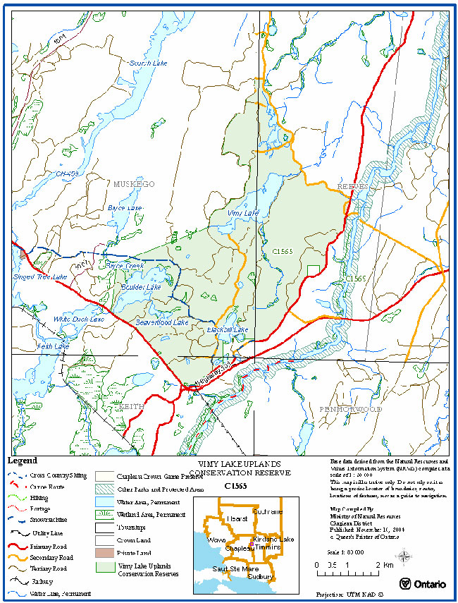
Vimy Lake Uplands Conservation Reserve totals 3,432(gazette) (ha) in size and is located approximately 13 kilometers east of Foleyet in the Chapleau and Timmins OMNR Districts in the Northeast Region. Chapleau District assumes responsibility for the management of the site. Table 1 provides administrative details of the site:
Table 1: Location and Administrative Details for the Vimy Lake Uplands Conservation Reserve
| Name | Vimy Lake Uplands Conservation Reserve |
|---|---|
| Site Region – Site District (Hills) | 3E-5 |
| Site Region – Site District (Crins and Uhlig, 2000) | Foleyet Ecodistrict 3E-5 in the Lake Abitibi Ecoregion 3E (Hills 1959, Crins and Uhlig, 2000) |
| OMNR Administrative Region/District/Area |
Northeast/Timmins - Chapleau/Area East |
| Total Area | 3432 ha |
| Regulation Date | To be announced |
| First Nations | James Bay Treaty No. 9 (First Nation communities affiliated with this treaty in the district of Chapleau include Brunswick House First Nation, Chapleau Ojibwe First Nation, Chapleau Cree First Nation and Missanabie Cree First Nation) |
| OBM map sheets | 42 B/1 and 42 B/8 |
| UTM Reference | 409534 |
| Municipality | None |
| Township | Muskego, Reeves, Keith |
| Status | 100% Crown lands |
| Watershed | 4LC |
| Wildlife Management Unit | WMU 30 |
| Forest Unit | Pineland-Martel / Gordon Cosens / Romeo Malette |
| Nearest Town(s) | Foleyet |
4.1.2 Physical description
The Vimy Lake Uplands Conservation Reserve is found in the Foleyet Ecodistrict 3E-5 (Hills, 1959; Crins and Uhlig, 2000) which lies within the larger Lake Abitibi Ecoregion 3E. A general description of this area with respect to earth and life sciences can be found in Appendix 9.1.
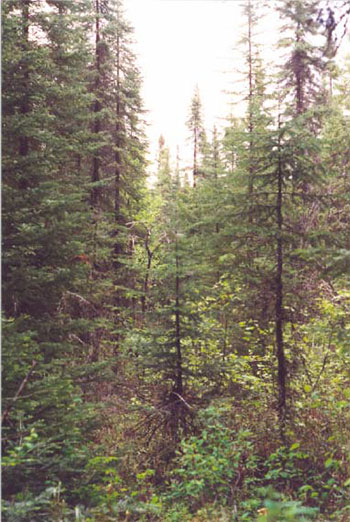
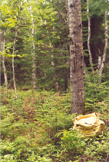
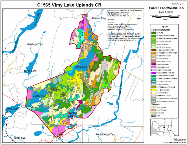
The conservation reserve falls within the Boreal Forest Region but contains certain species from the Great Lakes St. Lawrence Forest Region including black ash and sugar maple which are scattered or in isolated patches. The site contains 25 different forest communities and is dominated by mixed forest. Forest stands range in age between 0 – 179, most forest communities fall within a range of 30-59, 60-89 and 90-119. Black spruce and poplar communities are well represented within the site with white pine present throughout. Black spruce ranges from 30 to 149 years and occur centrally and in the eastern portion of the conservation reserve usually situated in the low lying areas. Trembling aspen is present in pure stands on highlands. Poplar communities range between 30 to 89 years in age and wrap around the black spruce communities in the center of the site and occur more centrally in the eastern portion. Balsam fir communities occur mainly in the eastern side of the site and range from 30 to 119 years in age. White cedar communities occur in the southwest and northern tip ranging from 60 to 119 years and white birch communities occurring along borders of the site in all directions ranging in age from 30 o 119 years of age (Northeast Region Planning Unit April 2004).
C1565 Vimy Lake Conservation Reserve: Sb conifer mixed forest community near the east boundary.
Photo 27-14 by John Thompson, September 22/01
C1565 Vimy Lake Conservation Reserve: Taken just north of the abandoned gravel pit off the old Highway 101. Sb mixedwood forest.
Photo 27-11 by John Thompson, September 22/01
The conservation area falls within the Groundhog River watershed which is part of the Moose River Basin of the Hudson Bay System (Department of Lands & Forests, 1974). Wetlands are located throughout the conservation reserve the dominant one being conifer swamp. Other wetlands that commonly occur within the conservation reserve include treed fen in the eastern section, treed bog mostly in the central section and shore fen occurring along a small stream leading into Vimy Lake. Other wetlands included shoreline fens and a wetland complex of alder thickets (Noordhof, J. 2004 & Cudmore, W. 2004). There are five main lakes within the conservation reserve these include Vimy, Boulder, Beaverflood, Blackbill, and South Scorch Lakes. Two of these are described as mid-sized lakes, Vimy which is located near the center of the site and Boulder Lake is in the southwest corner of the conservation reserve. The other three are considered to be small lakes (Campbell, J. 2004) and both South Scorch and Blackbill Lake being headwaters to the Groundhog river watershed (Cudmore, W. 2004).
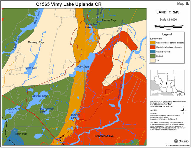
The surficial geology for this conservation reserve can be divided into two distinct areas, the southwest half and the northeast half. The south west half is dominated by till deposits and bedrock outcrop. Organic deposits are associated with the large wetland complex northeast and northwest of Boulder Lake.
The northeast portion of the site contains a combination of glaciolacustrine deposits, ice-contact stratified drift deposits and till deposits. Gravel and sandy gravel ice-contact stratified drift deposits are associated with an esker formation. This formation runs along a trail at the north end, through South Scorch Lake, down through Vimy Lake and down the east side of Blackbill Lake ending at its south corner. Till deposits are found at the northwest corner and east of Vimy Lake. Glaciolaustrine deposits can be found northeast of Vimy Lake and along the east side of the trail in that area. Organic deposits are scattered throughout the site, usually in areas where there are creeks and lowlands. Glaciofluvial outwash deposits are located southwest of Vimy Lake (Noordhof, 2004).
4.2 Administrative description
The Vimy Lake Uplands Conservation Reserve is currently in the final stages of the regulation process and once complete, will be formally protected under the Public Lands Act.
A copy of the site regulation description from the Ontario Gazette will be inserted in this document when it is published.
The Vimy Lake Uplands Conservation Reserve is located within three forest management units; the eastern portion of the site is located within the Gordon Cosens forest, the western portion is part of the Pineland-Martel forest and the southern tip of the site is located within the Romeo Malette forest.
4.3 History of the site
There has been a European presence in the area since the mid 1700's when competition in the fur trade became intense. Late in 19th century, the fur trade began decreasing as logging became the primary industry. The arrival of the railway through Foleyet and other areas of northern Ontario created further demand for lumber (railway ties) and increased logging activity, with the first sawmills appearing in the early 1900's. As a result of this change in industry the town of Foleyet, which is located just west of the conservation reserve, was established. The completion of the railway and Highway 101, which borders the site, further increased activity in this area. Given the close proximity to the town of Foleyet, the area, both including and surrounding the conservation reserve, was most likely harvested during this period and during the years to follow (Lindquist, S. 2004).
First Nations of the region may have additionally utilized the lands of the Vimy Lake Uplands Conservation Reserve in the past. There is no known registered archaeological remains found within the site (Von Bitter, R. 2004), although there is a suspected native cemetery in proximity (Ivanhoe Lake) to the site which indicates that area may have been used by Aboriginal people (Cudmore, W. 2004).
4.4 Inventories
The following table indicates what survey work has been done and what is required:
Table 2: Inventory and Survey Information for Vimy Lake Uplands
| Survey Level | Earth Science | Life Science | Cultural | Recreational |
|---|---|---|---|---|
| Reconnaissance Survey (RS) | Completed September 22nd, 2001 | Completed September 22nd, 2001 | Completed September 1st, 2004, no registered archeological sites found | Completed September 22nd, 2001 |
| Detailed | Not available at this time, contained within the Life Science Report | Draft Life Science Report July 27, 2004 | None planned at this time | Completed Recreational Report, August 2004 |
| Requirement | A complete inventory of earth science features needs to be completed as time and funding permits | The confirmation of further life science features may warrant additional analysis of landform vegetation units and FRI data | Ground survey of the roads and trails should be completed as time and funding permits to further assess current access and use |
5.0 State of the resource
The natural heritage of Ontario contributes to the economic, social and environmental well being of the province and its people. Protecting areas of natural heritage is important for many reasons, such as maintaining ecosystem health and providing habitat for species in order to maintain diversity and genetic variability. Protected areas also provide scientific and educational benefits, recreational and tourism opportunities, which bolsters local and regional economies, and they provide places where people can enjoy Ontario’s natural diversity while enhancing their own health and well-being. In order to protect this vital natural heritage, a protected areas system which represents the entire range of the province’s natural features and ecosystems, is needed (Natures Best, 1997).
Completing the system of parks and protected areas is based on the concept of representation – capturing the full range of natural and cultural values by protecting areas that contain the best examples of our history, natural features, species and ecosystems. The complete system must therefore protect a range of natural heritage values based on the geological, biological and cultural diversity of the province. The best examples of representative features are often considered to be provincially significant and may even be nationally or internationally significant. In addition, locally and regionally significant areas also contribute natural heritage values to the protected area system and have therefore been identified in some areas to meet the representation targets in each of the 'Ecodistricts'.
The primary value of this site is moderately broken shallow sandy till uplands lacustrine clay dominated by black spruce, poplar/aspen, balsam fir, white cedar, and white birch. In addition a weakly broken shallow sandy till plain is present dominated by old growth balsam fir, old growth white birch, and 60 to 119 year old white cedar (OMNR, 1999).
The site contributes to life science values by its black spruce and poplar forest communities which are all strongly represented. The site also contains many candidate old growth forests. Wetlands contribute locally to the system of protected areas as the site contains a good mixture of shoreline fens with alder thickets in some places or wetland complexes of alder thickets, beaver meadow to cedar swamps (Cudmore, W. 2004).
Additionally the site contributes to earth science features. The Vimy Lake Uplands Conservation Reserve contains bedrock-drift complexes, till deposits, bedrock outcrop, organic deposits, glaciolacustrine deposits, ice-contact stratified drift deposits, glaciofluvial outwash deposits and an esker system (Noordhof, J. 2004).
Quality of present representation:
The quality of the representation or the current characteristics of the natural features found within the conservation reserve are as important as the overall representative features that are being protected. A number of factors are considered in evaluating a site and they include the following criteria: diversity, condition, ecological factors, special features and current land use activities.
a) Diversity
Diversity is evaluated in terms of the number and range (i.e. amount of richness and evenness) of vegetative communities currently present within the conservation reserve. Natural landscapes and known generalized vegetative communities will be the scale used for this SCI. Future aerial or ground reconnaissance surveys will enhance the OMNR's knowledge of these features and possibly allow verification at a lower scale (e.g. species assemblages). Diversity is rated as high if the site contains more than 35 landform vegetation combinations, medium if is contains between 25 and 35 and low if it contains less than 25 landform vegetation combinations (Cudmore, W. 2004).
This conservation reserve shows a good diversity of forest communities spread out over a relatively large site. Overall, diversity for the Vimy Lake Uplands Conservation Reserve is considered to be medium given the variety of forest communities (25), the 27 different landform vegetation units, and the different wetlands represented within the site. Another contribution to the sites diversity is the change in topography throughout the site. This includes the esker system forming the islands in Vimy Lake, and lowland areas dominated by black spruce, which create various microhabitats (Cudmore, W. 2004).
b) Ecological factors
Ecological factors refer to the current design of the conservation reserve as noted by its size, shape, and buffering capacity to adjacent land use activities. Generally, larger sites with more diversity are better than small, non-diverse areas; sites with a more rounded or naturally delineated shape are better than long, linear sites; and sites that are linked to or near other protected areas are better than isolated protected areas. In addition, the site’s linkage to undisturbed landscapes also contributes to the conservation reserve’s ecological integrity.
Cultural boundaries dominate the conservation reserve. The site boundary follows Highway 101 on the southwest side. It then follows old Highway 101 (which is in a state of disrepair but still suitable for vehicular travel), until the Groundhog river where it is no longer traversable due to the removal of an old bridge. The boundary then follows an old forest access road that crosses Vimy Creek on the northeastern border which has been kept open by recreationalists (Mutter, T. 2004). Some natural feature boundaries occur around Blackbill Lake and a small section of an unnamed lake west of Boulder Lake (Campbell, J. 2004). Vectored boundaries are mainly on the western side, some of which have been vectored to follow an old trail that has since grown over (Mutter, T. 2004).
The Vimy Lake Uplands Conservation Reserve is well protected by its boundaries with the exception of the vectored border on the west side of the site. This unnatural boundary severs some core habitats in this area (Cudmore, W. 2004).
The Vimy Lake Uplands Conservation Reserve is situated adjacent to the recommended Groundhog River waterway provincial park, which also 'connects' to the Northern Claybelt Forest Complex Conservation Reserve. Collectively, these three protected areas compliment each other in the protection of natural heritage values by providing a larger corridor of protected landscape. This connected system of regulated areas enhances the ecological integrity of the provincial park and both conservation reserves.
Management activities within one of these protected areas will aim to be consistent with those in adjacent sites.
c) Condition
Condition is the degree of past human and natural disturbances observed or recorded for the site. Major natural disturbances in the Northeast Region are caused by fires, wind damage, floods, or insect and disease infestation. Human disturbances are wide ranging and could include forestry, mining, railways, roads, trails, dams, cottages or other development. Condition is rated as high if the area is more than 20% disturbed, medium if 10-20%, low less than 10%, pristine is less than 1% (Cudmore, W. 2004).
Fire is the leading disturbance in this ecoregion (3E). Other natural disturbances in this ecoregion have been caused by severe birch dieback and a massive spruce budworm infestation which took place during the years of 1968 to 1995. The resulting effect on the landscape has been vast areas of open, snag filled forests in which a variety of shrubs slow the regeneration of valuable softwood species and balsam fir in the understory of many areas. Forest tent caterpillar and windthrow damage also contribute greatly to the disturbance of the ecoregion (Cudmore, W. 2004).
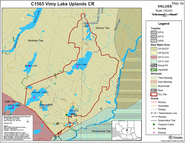
The disturbance of this site is low (less than 10% currently disturbed). Harvesting occurred in the 1960's in Muskego township, and some of this was re-harvested in 1996 (Cudmore, W. 2004). There is a tertiary road and several trail systems throughout the site which reflect old harvesting. These are currently used for fishing and hunting. Human disturbances include this network of trails, two gravel pits in the south and southeastern portions of the site, one trap cabin located on the southwest side of Blackbill Lake, and one private recreation camp permitted, authorized under a Land Use Permit (LUP). Garbage is currently a concern being observed within the site and may develop into a problem depending on the level of recreational activity within the conservation reserve (Cudmore, W. 2004).
d) Special features
Special features are those features that, in addition to the primary value of the site, add to the distinctiveness of a site. Examples of these features include interesting landscapes, habitats or vistas, Species at Risk (SAR) and other earth and life science features, including broader landscape elements that contribute to the natural heritage richness of Ontario.
The primary value of this site is moderately broken shallow sandy till uplands lacustrine clay dominated by black spruce, poplar/aspen, balsam fir, white cedar, and white birch. In addition a weakly broken shallow sandy till plain is present dominated by old growth balsam fir, old growth white birch, and 60 to 119 year old white cedar (OMNR, 1999). This is a result of the large variety in plant species of this particular ecoregion giving it an early onset of old growth conditions due to the higher fertility leading to higher productivity (Cudmore, W. 2004).
The Vimy Lake Uplands Conservation Reserve is in excellent shape and exhibits diversity with its high number of landform vegetation combinations and mix of different development stages within all forest communities including many old growth stands throughout the conservation reserve. Another contribution to the diversity is the previously mentioned significant changes in topography including the esker system and lowland areas scattered throughout the site. The site also has excellent access along the east and northeastern boundaries (Cudmore, W. 2004).
e) Current Land Use activities
As previously mentioned, the quality of the representation or the current characteristics of the natural features found within the conservation reserve are as important as the overall representative features that are being protected. Land use activities can have a substantial impact on the quality of representation within the conservation reserve.
Currently, portions of one bear management areas (BMA), one trapline and two commercial baitfish harvest areas (BHA) overlap the Vimy Lake Uplands Conservation Reserve. There is also a private recreation camp located at the south end of South Scorch Lake. This camp is authorized under an LUP. The site has numerous trails that have been used for access, primarily for hunting and angling opportunities with additional use for ATV and camping.
5.1 Social interest in area
5.1.1 Linkage to local community
Foleyet is a small community of approximately 380 people and it is assumed that the residents of Foleyet are the primary users of this site. In addition to C1565's proximity to the town of Foleyet, it is roughly half way between the City of Timmins and the Town of Chapleau along Highway 101 making it accessible to residents and visitors of these three communities. (Campbell, J. 2004).
This site provides the surrounding communities a protected area to enjoy activities which may include camping, hunting, fishing, nature appreciation, hiking, snow shoeing, snowmobiling, and ATV use. The area may also be used by people who have interest in visiting the adjacent Groundhog River Provincial Park. In addition to this, economic benefits to the region stem from trapping, hunting, angling, and other tourism and recreational opportunities in the area.
Highway 101 is a primary road running parallel to the southwestern border of the site and provides access to the conservation reserve. The southeastern portion of the conservation reserve can be accessed by old Highway 101. The northeastern portion of the conservation reserve may be accessed from an old forest access road that crosses Vimy Creek.
5.1.2 Aboriginal interests
The conservation reserve falls in the area of the James Bay Treaty No. 9. First Nations of the area may have utilized the lands of the Vimy Lake Uplands Conservation Reserve. Although there is a suspected native cemetery in proximity (Ivanhoe Lake) to the site which indicates that area may have been used by Aboriginal people (Cudmore, W. 2004), no archaeological remains are known to exist within the conservation reserve (Von Bitter, R. 2004). The designation of this area as conservation reserve and the subsequent planning, including this SCI, does not affect the treaty or aboriginal rights.
5.1.3 Other government agencies, departments or crown corporations
Other agencies or departments that may have an interest in this conservation reserve include the Ministry of Tourism and Recreation, the Ministry of Culture, the Department of Fisheries and Oceans Canada, the Ministry of the Environment, the Ministry of Northern Development and Mines, and the Ministry of Municipal Affairs and Housing. At this time, no other government agency has shown a specific interest with respect to this particular protected area.
5.1.4 Non Government Organizations and other Industry Interest
Industrial sectors that may have an interest in the Vimy Lake Uplands Conservation Reserve could include the forestry industry, the mining industry and the tourism industry. Non-government organizations that may have an interest in the Vimy Lake Uplands Forest Conservation Reserve could include numerous groups such as the Partnership for Public Lands, the Federation of Ontario Naturalists, Northwatch, the Northern Ontario Tourist Outfitters, the Baitfish Association of Ontario, the Foleyet & Area Chamber of Commerce, as well as local snowmobile clubs, trapper councils, and hunting and angling organizations.
5.2 Natural Heritage Stewardship
The Vimy Lake Uplands Conservation Reserve contributes to Ontario’s parks and protected areas system. Through formal protection under the Public Lands Act and long-term management direction, the site’s natural heritage values and representative features will be protected and/or enhanced.
By allocating these lands to the parks and protected areas system the Province has ensured a certain level of permanence by distinguishing this site and its values from the surrounding landscape. Each protected area contributes to Ontario’s natural and cultural heritage in its own unique way – whether it is a contribution to the preservation of an earth science value, a life science value, a recreational or economic opportunity or through protection afforded to cultural and historical values. The site’s earth and life science features, as described in section 4.1.2, make a number of contributions to the provinces natural heritage values (Burkhardt, B. 2004 & OMNR, 1999).
This site is also available for scientists and educators who wish to study various aspects of the sites features, while continuing to provide various recreational opportunities for communities in the area.
5.3 Fisheries and wildlife
The wildlife found within the site is consistent with typical wildlife found in Ecodistrict 3E-5, including the various types of birds and ungulates. In addition to this, there are numerous furbearing animals including beaver, marten, otter, black bear, fox, wolf and lynx (Landriault 2004).
There are a number of small but well defined lakes within the conservation reserve including Vimy, Boulder, Blackbill, Beaverflood and South Scorch. The fisheries values include walleye and northern pike in Boulder, Vimy and South Scorch Lakes and yellow perch in South Scorch Lake (Cudmore, W. 2004). There has also been identification of walleye spawning areas within the site (Landriault 2004). These lakes are sensitive to potential over fishing if there is a strong increase in recreational use.
Aerial surveys are completed on a district scale on a periodic basis. Surveys for moose have revealed many aquatic feeding areas within the site. There are two osprey nests located in the conservation reserve. In addition, a bald eagle was observed over the site during the aerial reconnaissance survey. To date, however, no detailed wildlife studies have taken place within the conservation reserve and so the importance of the site to wildlife species has yet to be determined.
5.4 Cultural Heritage Stewardship
There are no known registered archaeological sites values within the Vimy Lake Uplands Conservation Reserve (Von Bitter, R. 2004). Although, as mentioned there is a suspected native cemetery in proximity to the site which indicates that area may have been used by Aboriginal people (Cudmore, W. 2004).
If archaeological or cultural resources are discovered within the conservation reserve, management of the cultural heritage values will be consistent with 'Conserving a Future for Our Past: Archaeology, Land Use Planning & Development In Ontario' (Ministry of Citizenship, Culture and Recreation, 1997). If MNR receives proposals for activities that have the potential to disturb unidentified cultural heritage resources, the proposal will be screened against the draft 'Interim Cultural Heritage Guidelines for the RSFD class EA and the Provincial Parks and Conservation Reserve class EA' (OMNR July 19, 2004).
5.5 Existing development and Land Use
This conservation reserve contains one LUP for a private recreation camp. There are no other LUPs, patents, licenses of occupation, leases, mining tenure or any other form of land tenure.
At present, there is one other structure within the conservation reserve, which is a trap cabin. Existing commercial fur harvest is a permitted use within the conservation reserve. There are three main access roads to this site, Highway 101, old Highway 101 and an old forest access road which runs northwest from old Highway 101. There is also a tertiary road that travels north into the center of the conservation reserve. This is accessible by old Highway 101 just east of where old and new Highway 101 meet (Campbell, J. 2004).
5.6 Commercial and industrial use
One trapline (CP 19) and its associated trap cabin fall within the conservation reserve. In addition, one bear management area (CP 30-029) and two commercial baitfish harvest areas (CH0038 & CH0054) are also present within the site.
This conservation reserve has no mining tenure within it. Mining and surface rights have been withdrawn from staking within the conservation reserve boundaries under the Mining Act (RSO 1990 Chapter M.14).
Prior to the identification and regulation of this site as a provincial conservation reserve, portions of the area were harvested for timber. These areas have since been left to regenerate naturally (Lindquist, S. 2004).
5.7 Recreational use
Current recreational uses include hunting, angling, hiking, nature appreciation, ATV use, and snowmobiling. The tertiary road, several trail networks which have resulted from previous forest harvesting and the private recreation camp are the only form of existing infrastructure related to recreation within the site. Currently there are no proposals for new recreational uses or tourism facilities within this site.
5.8 Client services
Visitor services will primarily involve responding to inquiries about basic information such as natural heritage representation, permitted uses, access and boundaries. In addition to the provision of public information regarding the protected area, concerns with respect to public safety and area security will be addressed.
6.0 Management
6.1 Management planning strategies
Earth and life science features will be protected from adverse impacts by defining permitted uses, enforcing regulations (Ont. Reg. 805/94 PLA), monitoring site use and mitigating any identified concerns. The land use intent outlined in the Ontario’s Living Legacy Land Use Strategy and more specifically, Conservation Reserve Policy 3.03.05 will form the basis for the management planning strategies presented within this SCI. In addition, the management of this conservation reserve will take into consideration the land use intent of lands which border on the site and the neighboring adjacent Groundhog River Provincial Park to ensure that its values are not compromised by activities within the conservation reserve. For additional information on permitted uses refer to Appendix 9.2. For general policy information on provincial conservation reserves, please refer to the Ministry of Natural Resources Crown Land Use Policy Atlas (/page/crown-land-use-policy-atlas).
New land use activities and proposed development will be reviewed on a case by case basis. A review under the 'Class EA for PPCR' must be completed before any uses or developments are approved. The emphasis will be on ensuring that the natural values of the conservation reserve are not negatively affected by current or future activities.
Permitted uses in conservation reserves will generally follow the direction expressed in the Land Use Strategy as well as any prior commitments that have been made by the Ministry of Natural Resources Chapleau District office.
The development of this SCI and the long-term management and protection of the Vimy Lake Uplands Conservation Reserve will be under the direction of the OMNR's Chapleau District, Area East Supervisor.
6.2 State of the resource management strategies
The following sections outline some of the management strategies that have been developed to maintain and protect the identified values of the site. A detailed list of permitted uses within this conservation reserve can be found in Appendix 9.2 of this SCI.
6.2.1 Aboriginal interests
Traditional activities and Aboriginal rights as defined by the James Bay Treaty No. 9 will not be affected within the boundaries of this conservation reserve. All Aboriginal and treaty rights will continue to be recognized and will not be impacted by the designation of the area as a provincial conservation reserve.
6.2.2 Natural Heritage Stewardship
The management intent of this conservation reserve will be to protect natural ecosystems, processes and features, while continuing to allow compatible low-impact land use activities.
The OMNR recognizes fire as an essential process fundamental to the ecological integrity of conservation reserves. In accordance with existing Conservation Reserve Policy and the current Forest Fire Management Strategy for Ontario, forest fire protection will be carried out as on surrounding lands. Whenever feasible, the OMNR fire program will endeavor to use "light on the land" techniques, which do not unduly disturb the landscape in this conservation reserve.
Examples of light on the land techniques may include limiting the use of heavy equipment or limiting the number of trees felled during fire response efforts. Opportunities for prescribed burning to achieve ecological or resource management objectives may be considered. These management objectives will be developed with public consultation prior to any prescribed burning, and will be reflected in the document that provides management direction for this conservation reserve. Plans for any prescribed burning will be developed in accordance with the OMNR Prescribed Burn Planning Manual, and the Class Environmental Assessment for Provincial Parks and Conservation Reserves.
OMNR will provide leadership and direction for maintaining the integrity of this site as a natural heritage estate. Research, protection, education and understanding and interpretation of the natural heritage features of the site will be encouraged and fostered through local and regional natural heritage programs and initiatives.
The introduction of exotic and/or invasive species will not be permitted. Programs may be developed to control forest insects and diseases in the conservation reserve where these threaten significant heritage, aesthetic, or economic values. Where control is desirable and possible, it will be directed as narrowly as possible to the specific insect or disease. Biological control will be used wherever possible.
In addition, the collection and/or removal of vegetation and parts thereof will not be permitted unless otherwise stated in the conservation reserve policy/permitted uses table. However, subject to the 'Class EA for PPCR', the East Area Supervisor may authorize the collection of plants and/or parts of plants for the purposes site rehabilitation if required and for research or scientific study.
Exceptions based on the 'Class EA for PPCR' may be made for minor structures for monitoring and research for scientific purposes (see section 6.4).
6.2.3 Fish and wildlife
Fish and wildlife resources will continue to be managed in accordance with applicable policies and regulations prevailing in the area and under the direction of the Area East Supervisor.
Existing trapping, hunting and sport fishing will be permitted to continue, provided there are no significant demonstrated conflicts (OMNR, 1999).
6.2.4 Cultural heritage
As previously stated no registered archaeological have been identified in the Vimy Lake Uplands Conservation Reserve. If archaeological or cultural heritage resources are discovered within the conservation reserve, proposals pertaining to the development or use of these cultural resources will be subject to OMNR's Class Environmental Assessment (EA) Provincial Parks and Conservation Reserves Class EA. This may lead to screening through direction provided in 'Conserving a Future for Our Past: Archaeology, Land Use Planning & Development In Ontario' (Ministry of Citizenship, Culture and Recreation, 1997) as well as Policy 4.02.01 Cultural Heritage Screening, OMNR-MCzCR MOU, April 2001.
6.2.5 Existing development and Land Use
Authorized roads and trails currently existing can continue to be used. No new roads will be permitted within the conservation reserve, new trails may be considered subject to the 'Class EA for PPCR'. For details on permitted uses within the conservation reserve, please see Appendix 9.2. Should a new trail be proposed, special consideration will be given to the values found within the site and how the proposed trail may impact those values. In general, new trails should avoid low-lying areas and wetlands.
The sale of lands within this conservation reserve is not permitted as per direction outlined in the Land Use Strategy. Road realignment, energy transmission, communication and transportation corridors, resource roads, or construction of facilities are discouraged. It is recognized that in some circumstances there may be no viable alternatives in which case options to minimize potential impacts to the values of the site will be determined through applicable planning processes (OMNR, 1999).
Future development proposals will be reviewed on a case by case basis, subject to all relevant conservation reserve policies and the 'Class EA for PPCR'. Consideration will also be given to the effect that future development and/or additional access may have on the values of the neighboring Groundhog River Provincial Park.
6.2.6 Commercial and industrial use
The current level of commercial hunting and trapping will be permitted to continue. New trapping operations may be considered subject to the 'Class EA for PPCR'.
Existing commercial bear management operations are permitted to continue. The issuance of new licenses for existing commercial bear hunting operations will be permitted where areas have been licensed or authorized for the activity at any time since January 1, 1992, provided that the activity does not create or aggravate resource sustainability issues. New licenses will not be permitted in areas where a license for commercial bear management has not been issued since January 1, 1992 (OMNR, 2003).
New commercial tourism operations, including applications for commercial tourism outpost camps, main base lodges or associated facilities, may be considered in the context of this management document and will be subject to the 'Class EA for PPCR'.
Industrial activities such as timber harvesting, mining, and new hydro generation will not be permitted within the boundaries of the conservation reserve as per Policy 3.03.05. The existing authorized access roads and trails within the conservation reserve will be permitted to remain in use; however, no new access roads will be permitted.
6.2.7 Recreation /access
Recreation activities that have traditionally been enjoyed in this area are permitted to continue provided they do not significantly impact the values of the site (OMNR, 1999). Current recreational activities include camping, angling, hiking, hunting, ATV use and snowmobiling.
Access to the conservation reserve by motorized vehicles (e.g. snowmobiles and ATV's) will continue to be permitted on existing, authorized roads and trails providing it is compatible with the conservation reserve protected values and does not disturb sensitive wetland areas. The construction and or use of new roads will not be permitted. New recreational trails may be considered subject to the 'Class EA for PPCR'. Use of motorized vehicles off trail is not permitted except for the sole purpose of retrieving game (Cudmore, W. 2004).
Currently, no research or interpretive facilities exist within the conservation reserve. New recreational development or new recreation facilities may be considered subject to 'Class EA for PPCR'.
No new private recreation camps will be permitted in the conservation reserve.
6.2.8 Client services
Under the direction of the Area East Supervisor, Chapleau District, staff will respond to requests for information on the site pertaining to regulated boundaries, natural heritage values, current access and infrastructure, permitted uses or any other additional information that is required.
A general fact sheet regarding the values of this site will be prepared and made available to the public at the Chapleau District Office.
6.3 Specific feature/area/zone
The primary value of this site is moderately broken shallow sandy till uplands lacustrine clay dominated by black spruce, poplar/aspen, balsam fir, white cedar, and white birch. In addition a weakly broken shallow sandy till plain is present dominated by old growth balsam fir, old growth white birch, and 60 to 119 year old white cedar. The site also contains many candidate old growth forests.
All attempts will be made to disturb this community as little as possible. In the event that a portion of the community has to be disturbed to allow for inventory, research, or any other proposed activity, a screening through the 'Class EA for PPCR' will be completed to determine if such an activity is acceptable.
In the future, if the representative features of the site are threatened by increased use or development, it may be necessary to regulate access or permitted uses in certain areas. In such a case, special management areas may be developed. These areas would facilitate permitted/restricted activities for the protection of specific values. The creation of these areas would require additional planning beyond this SCI including public consultation and eventual plan amendment if approved.
6.4 Promote monitoring and research
Scientific research by qualified individuals, which contributes to the knowledge of natural and cultural heritage and to environmental and recreational management, will be encouraged. Research related to the study of natural processes will also be encouraged provided it does not harm the identified values of the conservation reserve.
This site may be considered as a potential monitoring and/or research site. The natural state of Vimy Lake Uplands Conservation Reserve especially in regards to the geological landforms, the many candidate old growth forests and the biological processes that occur in this landscape qualify the site as a possible ecological benchmark. The relatively easy access and the presence of undisturbed forest communities of the conservation reserve could provide both OMNR and associated partners potential sampling or monitoring areas. All research programs will require the approval of the Ministry of Natural Resources and will be subject to ministry policy and other legislation. Those interested in pursuing research within the conservation reserve must apply to the Area East Supervisor for approval. Applications to complete the research will follow guidelines as outlined in Procedural Guidelines C - Research Activities in Conservation Reserves (Conservation Reserve Procedure PL 3.03.05) or equivalent direction formulated by the OMNR Chapleau District Office. Approvals will meet all terms and conditions established by the OMNR Chapleau District Office.
The ministry may approve, on a case by case basis, the removal of any natural or cultural specimen by a qualified researcher. All such materials removed remain the property of the Ministry of Natural Resources.
Additional life and earth science requirements, as previously outlined in section 4.4, will refine the values of this site and assist with further development of management guidelines. As time and funding permits, the completion of more detailed life and earth science inventories will further help define the role of this conservation reserve within the system of provincially protected areas.
6.5 Implementation and plan review strategies
Implementation of this SCI will primarily involve monitoring activities to ensure adherence to the management guidelines. Other activities will include funding future life and earth science inventories, preparing a fact sheet highlighting the important natural heritage values of the conservation reserve, and responding to public inquiries about the site.
Implementation of this SCI and management of the conservation reserve are the responsibility of the East Area Supervisor. Partnerships may be pursued to address management needs. The Vimy Lake Uplands Conservation Reserve SCI will be reviewed on an ongoing basis. If changes in management direction are needed at any time, the significance of the changes will be evaluated. Minor changes, which do not alter the overall protection objectives, may be considered and approved by the Area East Supervisor without further public consultation and the plan will be amended accordingly. In assessing major changes, the need for a more detailed Resource Management Plan (RMP) will first be considered. Where a management plan is not considered necessary or feasible, a major amendment may be considered with public and First Nation consultation. Notification will additionally occur on the Environmental Bill of Rights Registry. The OMNR Regional Director will approve any major amendments.
This SCI and the Crown Land Use Atlas will be amended to reflect any changes in management direction.
6.6 Marketing strategies
The Vimy Lake Uplands Conservation Reserve will be promoted as a distinctive natural area having significant life science values. As mentioned above, a fact sheet will be prepared to inform the public about the values of this site.
7.0 References
Campbell, J. 2004. Recreation Inventory Report - Vimy Lake Uplands (C1565), Draft Report, OMNR
Chapman, L.J. and M.K. Thomas. 1968. The Climate of Northern Ontario. Canadian Department of Transport, Meteorological Branch, Toronto. Climatological Studies Number 6. 58 pp.
Crins, W.J. and Peter W.C. Uhlig. 2000. Ecoregions of Ontario: Modifications to Angus Hills' Site Regions and Districts. Revisions and Rationale. 7pp and map.
Cudmore, W. 2004. Vimy Lake Uplands Conservation Reserve (C1565) Life Science Checksheet – Stepember 4, OMNR
Department of Lands & Forests. 1974. Watershed Divisions – Algoma, Sudbury and Timiskaming. Map 22 WD. OMNR.
Hills, G.A. 1959. A ready reference to the description of the land of Ontario and its productivity: Division of Research Ontario Department of Lands and Forests. Maple, Ont. A-4.
Landriault, L. 2004. Personal Communication
Lindquist, S. 2004. Personal Communication
Mutter, T. 2004. Personal Communication
Noordhof, J. 2004. Conservation Reserve Earth and Life Science Information Memo- C1565 Vimy Lake Uplands, OMNR
Ontario Ministry of Natural Resources. 1983. Chapleau District Land Use Guidelines.
Ontario Ministry of Natural Resources (OMNR). 1997. Nature’s Best: Ontario’s Parks and Protected Areas, A Framework and Action Plan. Lands and Natural Heritage Branch, The Natural Heritage Section, Peterborough, Ontario.
Ontario Ministry of Natural Resources 1997. Conservation Reserve Policy and Procedure PL3.03.05. OMNR. 30pp.
Ontario Ministry of Natural Resources. 1999. Ontario’s Living Legacy Land Use Strategy. Queen’s Print for Ontario.
Ontario Ministry of Natural Resources. 2000. Beyond 2000 – Ministry of Natural Resources Strategic Directions (2000). OMNR
Ontario Ministry of Natural Resources. September 2000. Policy Clarification for Conservation Reserves.
Ontario Ministry of Natural Resource, June 25, 2003. Memo: Direction for Commercial Use Activities in Provincial Parks and Conservation Reserves.
Ontario Ministry on Natural Resources, July 2, 2003. Vimy Lake Uplands Conservation Reserve (C1565) Fact Sheet.
Ontario Ministry of Natural Resources. July 19, 2004. Draft 'Interim Cultural Heritage Guidelines for the RSFD Class EA and the PPCR Class EA'.
Northeast Region Planning Unit. April 2004. C1565 Uplands Vimy Lake Uplands CR – Forest Communities, OMNR.
Poser, Scott. 1992. Report on the Status of Provincial Parks in the Site Regions and Districts of Ontario – Draft Report.
Rowe, J.S. 1972. Forest Regions of Canada. 20 pp.
Schilf, Johanna and John E. Thompson. 2001. Planning Process for Conservation Reserves: Statement of Conservation Interest and Resource Management Plans, Northeastern Region Guidelines. OMNR.
Von Bitter, R. 2004. Personal Communication
8.0 Maps
Map 8.1: Vimy Lake Uplands Conservation Reserve Location Map
Map 8.2: Vimy Lake Uplands Conservation Reserve Boundary Map
Map 8.2: Vimy Lake Uplands Conservation Reserve Values Map
Map 8.4: Vimy Lake Uplands Conservation Reserve Vegetation Map
Map 8.5: Vimy Lake Uplands Conservation Reserve Earth Science Map
9.0 Appendices
Appendix 9.1: General description of the region
Climate
Chapleau District is situated entirely within the Height – of – Land climatic region of Northern Ontario (Chapman and Thomas, 1968). The climate can be classified as continental, but is somewhat modified by elevation, and particularly in the southwestern part of the District, by the influence of Lake Superior. Most of the District’s precipitation comes in the summer and fall as a result of cyclonic storms, although thunderstorms are also important. (DLUG Background Information – p.7) The frost-free period for the town of Chapleau extends from mid June to early September, while temperatures range from a January mean of –15.6° C to a July mean of 16.7° C. (DLUG)
Characteristics of the Ecoregion and Ecodistrict – Found in the Natural Heritage Site District report.
The Vimy Lake Uplands Conservation Reserve is located in the Foleyet Ecodistrict (3E-5) which is found in the Lake Abitibi Ecoregion (3E). This region is found to contain moderately to gentle rolling bedrock, generally covered by deep deposits of clay, silt, and sand. The Foleyet ecodistrict is characterized by gently rolling plains of thinly covered rock knobs, sandy outwash and silty depressions. Material is generally acidic (granitic), locally overlain by low-base and low lime materials. Deep deposits cover one-quarter of the area with the remaining areas being very shallow to moderately deep. At the site level the underlying granitic, volcanic and sedimentary rocks are of the Precambrian age and from them the shallow till overburden has inherited varying degrees. In the central and western portions the till overburden is richest and rocks such as greenstone occur (Cudmore, W. 2004).
Forest Region - Found in the Conservation Reserves binder
The Vimy Lake Uplands Conservation Reserve is found within the Missinabi-Cabonga Section of Rowe’s (1972) Boreal Forest Region. The Missinabi-Cabonga Section contains mixed forests of balsam fir, black spruce and white birch with scattered white spruce and trembling aspen. The presence of eastern red and white pine can be found on rocky shores and ridges, but only to a small degree due to past logging operations. Jack pine is situated along rivers and found in association with black spruce on poor rocky soils. Black spruce is also found in association with tamarack and white cedar in wet lowland areas.
Appendix 9.2: Permitted Uses
Commercial uses
| Issue and Activity | Permitted | Explanation |
|---|---|---|
| Commercial fishing - new | Maybe | New operations can be considered subject to the 'Class EA for PPCR' |
| Commercial fishing - existing | Yes | Existing uses permitted to continue unless there are significant demonstrated conflicts |
| Commercial fishing - transfer | Maybe | Transfers will be considered within the context of the SCI, subject to the 'Class EA for PPCR' |
| Bait-fish harvesting - new | Maybe | New operations can be considered subject to the 'Class EA for PPCR' |
| Bait-fish harvesting - existing | Yes | Existing uses permitted to continue unless there are significant demonstrated conflicts |
| Bait-fish harvesting - transfer | Maybe | Requests for transfer will be dealt with on an on-going basis subject to the 'Class EA for PPCR' |
| Commercial bear hunting - New | No | New operations will not be permitted. New operations are defined as an activity that has not licensed or authorized since January 1, 1992. |
| Commercial bear hunting - existing | Yes | Existing operations will be permitted to continue indefinitely. Existing operations are defined as an activity that has been has been licensed or authorized at any time between January 1, 1992 and June 25, 2003. |
| Commercial bear hunting - transfer | Maybe | Requests for transfer will be dealt with on an on-going basis and not deferred until the completion of a SCI or RMP |
| Commercial fur trapping - New | Maybe | New operations may be considered subject to the 'Class EA for PPCR', including consideration for the associated trails that may be required |
| Commercial fur trapping - existing | Yes | Existing uses permitted to continue unless there are significant demonstrated conflicts |
| Commercial fur trapping - transfer | Yes | Requests for transfer will be dealt with on an on-going basis subject to the 'Class EA for PPCR' |
| Trapping cabins - New | No | Not permitted |
| Trapping cabins - Existing | Yes | Existing use are permitted to continue, including repair and replacement, as long as the scale and function are not significantly altered. Relocation may be permitted if consisted with protection of natural heritage values. |
| Trapping cabins - transfer | Yes | Trapping cabins are included in the transfer of a commercial fur trapping licence |
| Outpost camps/tourism facilities - New | Maybe | New tourism facilities can be considered during planning |
| Outpost camps/tourism facilities - Existing | Yes | Existing authorized tourism facilities can continue unless there are significant demonstrated conflicts. Tourism facilities can apply to upgrade tenure from LUP to lease. Applications will be subject to the 'Class EA for PPCR' |
| Outpost camps/tourism facilities - transfer | Maybe | Requests for transfer will be dealt with on an on-going basis subject to the 'Class EA for PPCR' |
| Wild rice harvesting - existing | Yes | Existing uses permitted to continue unless there are significant demonstrated conflicts |
| Wild rice harvesting - transfer | Maybe | Requests for transfer will be dealt with on an on-going basis subject to the 'Class EA for PPCR' |
| Food harvesting - new | Maybe | New operations can be considered subject to the 'Class EA for PPCR' |
| Food harvesting - existing | Yes | Existing uses permitted to continue |
| Food harvesting - transfer | Maybe | Requests for transfer will be dealt with on an on-going basis subject to the 'Class EA for PPCR' |
Industrial activities
| Issue and Activity | Permitted | Explanation |
|---|---|---|
| Energy transmission corridors and communication corridors - existing | Yes | Permitted to continue |
| Energy transmission corridors and communication corridors - new | No | New corridors should be discouraged through planning however it is recognized that in some circumstances there will be no alternatives. |
| Commercial hydro power generation | No | Not permitted |
| Commercial timber harvest | No | Not permitted |
| Cutting of trees by leaseholders, cottagers, for fuel wood and other small-scale uses | No | The cutting of trees for non-commercial purposed is not permitted. Exceptions may be authorized by permit, subject to a review and determination of the impact that such cutting would have on natural heritage values. This flexibility is intended only for leaseholders, cottagers and other property owners who do not have road access to their property. |
| Timber salvage | Maybe | If provided for in an SCI or RMP, standing, fallen or sunken trees may be removed for resource management purposed. Such trees may be marketed if economical |
| Forest renewal in recently harvested areas | Yes | Renewal can be conducted where it will be of net benefit to the protected area. Review and approval of the proposals must be completed by appropriate silvicultural and program staff responsible for the management of the protected area in order to determine what actions would best support the long- term ecological integrity of the area. |
| Extraction of peat, soil, and aggregate | No | Not permitted |
| Mining and Mineral Exploration | No | No new exploration on untenured land is permitted. All existing mining land tenure within the conservation reserve including mining claims, leases, licenses of occupation and patents, will remain protected under the Mining Act and will be treated as any other in the Province |
| Roads - existing | Yes | Existing authorized roads can continue to be used. With regards to resource access roads, where alternative access does not exist or road relocation is not feasible, road will continue to be available for access. Continued use includes maintenance and may include upgrading. |
| Roads - new | No | New roads for resources extraction will not be permitted except for those identified in Forest Management Plans before March 31, 1999 and for which no viable alternative exists. |
| Private access roads - existing | Yes | The maintenance of existing roads will be permitted, however upgrading will not be permitted |
| Private access roads - new | No | Where there is no prior commitment, new private access roads will not be permitted. Where OMNR made a commitment prior to March 29, 1999, to permit a private access road within a recommended protected area, the road proposal will be subject to completion of a public planning process. |
Recreational activities
Issue and Activity Permitted Explanation
| Issue and Activity | Permitted | Explanation |
|---|---|---|
| Sport fishing | Yes | Existing and new uses permitted to continue |
| Sport Hunting | Yes | Existing and new uses permitted to continue |
| Motorized boating | Yes | Existing and new uses permitted to continue |
| Canoeing/Kayaking | Yes | Existing and new uses permitted to continue |
| Non-trail ATV use | No | Non-trail ATV use may be permitted for direct retrieval of game only |
| Recreation Trail - existing (motorized and non- motorized) | Yes | Existing authorized trails can continue unless there significant demonstrated conflicts |
| Recreation Trail - new (motorized and non- motorized) | Maybe | New trails can be considered subject to the 'Class EA for PPCR' |
| Private recreation camps - new | No | Not permitted |
| Private recreation camps - existing | Yes | Existing authorized recreation camps permitted to continue and may be eligible for enhanced tenure but not for purchase of land (enhanced tenure being defined as anything beyond the term and form of current tenure). Enhanced tenure is not guaranteed and will be addressed through a screening process, such the 'Class EA for PPCR' |
| Private recreation camps - transfer | Maybe | Requests for transfer will be dealt with on an on-going basis subject to the 'Class EA for PPCR' |
Science, education and nature appreciation
| Issue and Activity | Permitted | Explanation |
|---|---|---|
| Research | Yes | Any proposed research activity must be approved by the Area Supervisor. |
| General Walking | Yes | Existing and new uses permitted to continue |
| Photography and Painting | Yes | Existing and new uses permitted to continue |
| Wildlife Viewing | Yes | Existing and new uses permitted to continue |
| Outdoor Education/ Interpretation | Yes | Existing and new uses permitted to continue |
| Collecting | No | Collecting may only be permitted as part of an authorized research project. The issuance of permits will be considered on a per-site basis. |
Other
| Issue and Activity | Permitted | Explanation |
|---|---|---|
| Land Disposition - sale | No | Sale of land is not permitted with some types of minor exception (road allowances, installation of septic system, etc.) where it does not detrimentally affect the |