Woodland caribou signature site vegetation management plan
This is a plan to manage vegetation. One way to manage vegetation is by managing fire. This is a plan to manage fire in the entire Woodland Caribou Signature Site. Other vegetation management activities in this plan (e.g. re-vegetation of highly impacted sites, invasive species control and cultural vegetation management by First Nations) apply to Woodland Caribou Provincial Park only.
Species Conservation Act now in force
The Endangered Species Act, 2007 (ESA) and its regulations have been repealed. The Species Conservation Act, 2025 (SCA) and its regulations are now in force. Find more information on the Environmental Registry of Ontario (notice 025-0380 , notice 025-0909) and e‑Laws.
This information provides general guidance only. If you are planning an activity that may affect a species on the Protected Species in Ontario List, review the SCA and its regulations. You should also seek appropriate advice, such as legal or scientific advice, or contact SAROntario@ontario.ca.
If there is any inconsistency between this webpage and the SCA or its regulations, the legislation prevails.
I am pleased to present the vegetation management plan for the Woodland Caribou Signature Site. This management plan will reflect Ministry of Natural Resources and Forestry’s (MNRF) intent to meet the objectives of this site.
Signed by
Doug Gilmore
Park Superintendent, Woodland Caribou Provincial Park
Date: Dec. 11, 2015
Signed by
Randy Crampton
Fire Management Supervisor, Red Lake District
Date: Dec. 11, 2015
Signed by
Pat Harvey
Fire Management Supervisor, Kenora District
Date: Dec. 15, 2015
Signed by
Dave Cleaveley
Fire Response and Operations Manager, Northwest Region
Date: Dec. 24, 2015
Signed by
Trevor Park
A/District Manager, Red Lake District
Date: Jan. 6, 2016
Signed by
Leo Heyens
A/District Manager, Kenora District
Date: Dec. 15, 2015
Signed by
John Swick
Northwest Zone Manager, Ontario Park
Date: Jan. 12, 2016
Preface
A Vegetation Management Plan has been prepared in order to maintain and restore ecological integrity (EI) and achieve resource management objectives as they relate to vegetation within the Woodland Caribou Signature Site (WCSS). This plan incorporates and adaptively manages fire, along with other vegetation management activities (e.g. re-vegetation of highly impacted sites, invasive species control, and cultural vegetation management by First Nations). A fire response plan is embedded within the larger vegetation management plan and was prepared in accordance with the Fire Management Planning Guidelines for Provincial Parks and Conservation Reserves. The fire response plan applies to the entire WCSS while all other vegetation management aspects apply to Woodland Caribou Provincial Park (WCPP) only. This Vegetation Management Plan will replace the Woodland Caribou Signature Site Fire Response Plan (2010).
The vegetation management plan is an amendment to the approved Woodland Caribou Signature Site Management Plan (2007). It provided an opportunity for Aboriginal, stakeholder and public involvement.
Partnership with First Nation Communities
The WCSS is considered a cultural landscape; a geographical area that has been modified, influenced or given special meaning by people (Parks Canada, 1994). Aboriginal peoples have lived in close relationship with the boreal forest since time immemorial, and therefore, their associated activities including vegetation management, help to form the cultural and ecological landscape (Davidson-Hunt, 2010; Sauer, 1925; Leighly, 1963).
The Manitoba First Nation community of Little Grand Rapids and the Ontario First Nation communities of Grassy Narrows, Pikangikum, Lac Seul, Wabauskang, and Wabaseemoong all have asserted traditional land use areas within the WCSS. The WCSS is located within Treaty 3 and Treaty 5. Members of these First Nation communities have worked very closely with Ontario Parks/MNRF in the development of this plan. Some communities feel very strongly, as does Ontario Parks, that information transferred between the groups, since 2002, has contributed to an ongoing, mutually beneficial partnership.
Custodial stewardship activities by First Nation people have taken place within the WCSS for thousands of years and continue to this day. Their close relationship with the land has shaped the ecosystem, physically and culturally. "Ahneesheenahbay ohtakeem (our ancestral lands) is not merely a landscape modified by human activity but a way of relating to the land, a way of being," (Pikangikum First Nations and Ministry of Natural Resources 2006). Activities such as the burning of marshes to improve wildlife habitat and the planting of wild rice may not occur as frequently as they did historically, but remain interconnected to the cultural and ecological integrity of the WCSS. Many First Nation experts, such as elders, trappers and lands coordinators, who have led these management practices, have been integral in providing knowledge and understanding of the WCSS landscape as the plan has developed and will continue to be as the plan is implemented and monitored.
Introduction
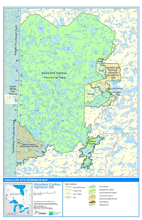
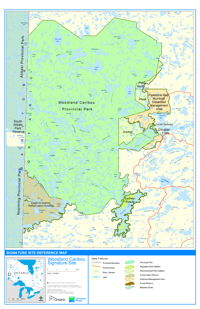
The WCSS is composed of Woodland Caribou Provincial Park, two park additions, three recommended park additions, Eagle-Snowshoe Conservation Reserve, Pipestone Bay-McIntosh Enhanced Management Area, and Woodland Caribou Forest Reserve (Appendix B).
The WCSS is a fire-adapted boreal landscape in which the terrestrial ecosystem is capable of sustaining the very large, high intensity forest fires that are responsible for its existence.
"The Creator created the Thunderbird to burn the forests so the forests can regrow to make food for the animals."
Whitehead Moose, 2006 (Whitefeather Forest Management Corporation, 2006)
Forest fires play a significant role in First Nations culture and the renewal of the boreal forest landscape. Information provided by Wabaseemoong First Nation Elders at a Vegetation Management Plan Scoping Meeting in 2009 reported that fire is the Creator’s work and plays an important role in forest renewal. Elder Eli Carpenter stated that "fire works on the decaying forest and provides good healthy growth. For example, there are usually good blueberries two to three years after a fire". Pikangikum Elders (2006) comment on seeing the land "reborn" following a fire.
"I was amazed by what I have seen on the land. The way everything was reborn with fire. Everything burnt right to the ground. The soil burnt, the trees [burnt]. Everything became clear ground. That is the sign that the land is being reborn."
Oliver Hill, 2006 (Miller, 2008)
Forest fire plays an important ecological role in the boreal ecosystems that cannot be duplicated by any other natural or anthropogenic process (Parks Canada, 2009). Fire intensity, frequency and rates of spread affect the function, composition and structure of an ecosystem by producing a mosaic of plant communities of different ages and species composition on the landscape. Fire creates this diversity by burning at varying intensities and speeds, thereby affecting different areas of the forest structure from the amount of soil/duff burned to the degree of tree mortality. Periodic fires also reduce the amount of accumulated fuel on the forest floor. In addition, fires stabilize insect and disease populations and recycle nutrients bound up in the litter and woody debris (Heinselman, 1996). The suppression of fires in similar ecosystems to that of WCSS have resulted in the succession of forests to less fire tolerant species, making them unsuitable for species that inhabit fire adapted environments (Johnson and Miyanishi, 1995; Heinselman, 1981). These suppression activities have in turn affected the wildlife species which use these forests.
Forest fire response activities for all fires that occur within WCSS are currently directed by the Woodland Caribou Signature Site Fire Response Plan (2010). The current WCSS Fire Response Plan begins to integrate fire back onto the landscape, but it does not fully address the need to maintain, and where possible, restore ecological integrity within the WCSS. To fully address the maintenance and restoration of ecological integrity within the WCSS, a comprehensive Vegetation Management Plan which incorporates and adaptively manages fire response and use along with other vegetation management techniques (e.g. invasive species control and custodial stewardship responsibilities with First Nations) is required.
Planning context
The intent of a Vegetation Management Plan is to establish policy direction regarding vegetation management in order to maintain, or restore where necessary, ecological integrity within a specified boundary.
The intent of this plan is to:
- incorporate vegetation management techniques which are reflective of the custodial stewardship responsibilities of the sites' First Nation inhabitants.
- provide direction to guide habitat renewal and protection of important species at risk (SAR) habitat, particularly woodland caribou and wolverine habitat.
- provide direction which balances the ecological role of fire on WCSS landscape, while providing for the protection of human life, property and cultural values within the WCSS and adjacent lands.
- amend the Woodland Caribou Signature Site Management Plan by providing additional enhanced policy direction with respect to fire and other vegetation management.
- describe various projects subject to A Class Environmental Assessment for Provincial Parks and Conservation Reserves (2005) and A Class Environmental Assessment for Resource Stewardship and Facility Development (2003).
- replace the current Woodland Caribou Provincial Signature Site Fire Response Plan (2010).
Purpose statement
The purpose of a Woodland Caribou Signature Site Vegetation Management Plan is to maintain and restore ecological and cultural integrity of WCSS by managing vegetation through fire response, First Nations customary stewardship, invasive species prevention, and site restoration.
Legislation and policy
Legislation, policies, strategies and planning documents influence how fire and vegetation management planning occur within the WCSS. These include, but are not limited to: Ontario’s Provincial Parks and Conservation Reserves Act (2006); The Woodland Caribou Signature Site Management Plan (2007); Ontario’s Wildland Fire Management Strategy (2014); Fire Management Policy for Provincial Parks and Conservation Reserves (FM:2:12/PAM7.02); Forest Fires Prevention Act (1990); Caribou Conservation Plan (2009b); and the Endangered Species Act (2007a). The Vegetation Management Plan Background Information and Options (OMNR 2012) outlines how each of these influences vegetation and fire management planning within the WCSS.
Relationship to protected area management direction
A main objective of provincial parks and conservation reserves is "To permanently protect representative ecosystems, biodiversity and provincially significant elements of Ontario’s natural and cultural heritage and to manage these areas to ensure that ecological integrity is maintained" (PPCRA 2006). The Woodland Caribou Signature Site Management Plan (2007) recommends the development of a fire management plan to promote the ecological role of fire (section 11.12, p. 36). The Woodland Caribou Provincial Park Management Plan has outlined the need for a vegetation management plan, including fire management planning, to address ecological and cultural integrity objectives (section 11.2, p. 36). This vegetation management plan amends the management direction for the various land use components of the WCSS by providing enhanced policy direction regarding fire management and vegetation management.
The fire response plan applies to the entire WCSS (Section 9.0) while all other vegetation management aspects (5.0, 6.0, 7.0, and 8.0) apply to WCPP only. Portions of the signature site outside of WCPP have existing guidelines regarding wild rice, vegetation restoration, and invasive species. Goals and objectives outlined in this plan do not apply to these areas.
Description of planning area
Location
The WCSS is located in northwestern Ontario, approximately 30 kilometres west of the town of Red Lake, 50 kilometres north of the community of Wabaseemoong and 60 kilometres south of the community of Pikangikum (Appendix A). The WCSS is located within the Kenora and Red Lake administrative districts of the Ontario Ministry of Natural Resources and Forestry.
Woodland Caribou Signature Site
The WCSS is composed of WCPP, two park additions, three recommended park additions, Eagle-Snowshoe Conservation Reserve, Pipestone Bay-McIntosh Enhanced Management Area, and Woodland Caribou Forest Reserve (Appendix B). The signature site contains important natural and cultural heritage values, as well as tourism and recreational use. It was identified as a signature site under Ontario’s Living Legacy Land Use Strategy, during the Lands for Life planning process. The objectives of that process were to: "complete Ontario’s system of parks and protected areas within the planning area; recognize the land use needs of the resources based tourism industry; provide the forest, mining, and other resource industries with greater land and resource certainty; and, enhance angling, hunting, and other Crown land recreation opportunities" (OMNR 2007).
Administration
The administration and management of WCPP and park additions are the primary responsibility of the Park Superintendent with broad direction being received from the Northwest zone office of Ontario Parks located in Thunder Bay. Red Lake District office has the responsibility for the Pipestone Bay-McIntosh Enhanced Management Area (EMA) and the Woodland Caribou Forest Reserve (FR). Kenora District office has administrative and management responsibility for the Eagle-Snowshoe Conservation Reserve. The Forest Fire Management Headquarters of Red Lake and Kenora Districts jointly share the responsibility for fire management activities within the WCSS. The signature site provides the opportunity to work across jurisdictional boundaries and MNRF programs for landscape management.
Planning areas adjacent to the signature site
Pipestone Bay-McIntosh Enhanced Management Area (EMA) and Forest Reserve (FR) components of the WCSS are part of the Red Lake Forest Management Unit (FMU). The Whiskey Jack FMU borders the WCSS to the southeast, the Kenora FMU to the south, the Whitefeather FMU to the north. Regulated protected areas in the Whitefeather Forest that abut the WCSS include Weeskayjahk Ohtahzhoganeeng (Lake Country) 265,751 hectares, and Kahnahmaykoosayseekahk (Valhalla-Trough Lake) 4,808 ha. Little Grand Rapids' Dedicated Protected Area (188,738 ha), also borders the signature site to the northwest. (Appendix A). It is a priority of Ontario Parks to integrate goals and objectives of adjacent land use areas in the future to coordinate vegetation and fire management efforts across the landscape.
The western edge of the WCSS borders the province of Manitoba and three of its protected areas; Atikaki Provincial Wilderness Park (MB), Nopiming Provincial Park (MB) and South Atikaki Provincial Park (MB) (Appendix A). The total contiguous protected area between the two provinces encompasses more than one million hectares which allows for increased opportunities to promote a natural fire regime at the landscape level. Ontario and Manitoba have agreed to work cooperatively and coordinate resource management activities including vegetation management (Interprovincial Wilderness Area MOU, 2008). Management decisions will need to be made collaboratively when fires cross jurisdictional borders, such as with the Manitoba/Ontario Quick Strike Agreement for fires occurring in proximity to the provincial border (Manitoba Ontario 2012).
Environment
A complete summary of climate, landforms, geology, topography, soils, dominant vegetation and boundary configuration is described within the Woodland Caribou Signature Site Vegetation Management Plan Background Information and Options (2012).
Wild rice management
Management of wild rice within WCPP
Wild rice is the only plant currently commercially harvested in WCPP. There are a number of wild rice licences currently held within WCPP, however at this time commercial wild rice harvest activity is low due to low market values. Harvesting may increase when markets change.
Wild rice has traditionally been sowed in shallow water along the paths of First Nations travel routes. It has also been determined that rice was transplanted not only as a main food and economic source but also to provide food for ducks and muskrats. The purpose was to increase the population of these animals to improve hunting and trapping (Vennum 1988). Wild rice will continue to play an important role in the food supply and culture of First Nation people. For further information on wild rice harvesting in the WCSS, refer to Woodland Caribou Signature Site Vegetation Management Plan Background Information and Options section 7.0 (OMNR 2012).
Existing commercial wild rice licences within WCPP are permitted to continue indefinitely. New commercial wild rice licences are not permitted unless the proposed new commercial activity is related to the exercise of Aboriginal and treaty rights.
Goals and objectives
- Maintain and restore ecological integrity (EI) and cultural integrity within WCPP
- Promote the ecological and cultural role of wild rice management and the customary practices of First Nations people within WCPP
- Participate in resource management planning to avoid or mitigate impacts to wild rice beds from flooding or water level fluctuations
- Continue to work with local First Nations to further MNRF's understanding of the traditional role of wild rice management as a customary activity
- Ensure education occurs on the importance of wild rice management within WCPP
- Create educational resources with First Nations partners describing wild rice management in the signature site
Vegetation restoration
Restoration of impacted sites in WCPP
Camping will occur on designated campsites, focussed on sites resistant to degradation or erosion. This is intended to concentrate camper use and reduce impact in sensitive areas. Maximum party size is enforced to reduce site impact. If a campsite has been overly impacted, it may be removed from the designated campsite map and either rehabilitated or allowed to regenerate naturally. Campsites, as well as portages, are continuously monitored to assess deterioration and any required management. Rehabilitation may also be required at sites where infrastructure such as private cottages and commercial tourism facilities has been removed.
It is the preferred approach to allow impacted sites to revegetate naturally. In some cases it may be necessary to assist seed establishment by raking compacted soil. It may also be necessary in highly impacted areas to plant species native to the park. Appropriate native seed or plant sources would be determined at that time.
Goals and objectives
- Maintain and restore Ecological Integrity (EI)
- Develop an adaptive designated campsite system with EI principles incorporated within
- Maintain an ongoing evaluation of campsite use and impacts
- Establish campsites and portages in areas resistant to degradation
- Allow camping at designated campsites only
- Restrict development in nature reserve zones to prevent disturbance to significant or rare plant species
- Relocate portages causing environmental damage if necessary
- Stabilize portages to reduce impact where relocation is not possible
- Temporarily or permanently close degraded campsites or portages to allow impacted sites to regenerate naturally
- Restore vegetation on impacted sites to prevent erosion if necessary
- Maintain ground cover at campsites
- Ensure education occurs about the importance of light on the land practices
- Liaise with camp owners, trappers, and other stakeholders to prevent negative impacts to vegetation
- Develop education aids for visitors of acceptable and unacceptable behavior, such as the Leave No Trace program
- Inform visitors of current impacts/conditions
Non-native and invasive species
Non-native plant and insect species (insects that affect vegetation) in WCPP
Within WCPP, non-native plant or insect species will not be deliberately introduced. Non-native species include those that are not native to WCPP and the ecoregion in which it lies. Non-native species include invasive species which can invade and greatly alter ecosystems. Where feasible, control actions may be taken to eliminate or reduce the threat of non-native species which may negatively affect the health or diversity of naturally occurring populations in these areas.
Currently plant species non-native to the WCPP ecoregion are only thought to be found at land tenure sites. Many private cottages and commercial tourism facilities have groomed lawns and decorative plants. Monitoring the presence and spread of non-native species will be critical in protecting the park ecosystem and developing effective activities to prevent them from becoming fully established. When management controls are necessary, techniques will be used so as to minimize effects on other components of the park environment.
Goals and objectives
- Maintain and restore Ecological Integrity (EI)
- Work with adjacent areas to identify high risk non-native species
- Identify high risk pathways for the introduction of non-native species and proactively prevent introduction
- Monitor for non-native species at high risk areas (e.g. access points, portages, private cottages and commercial tourism facilities etc.) and develop action plans for their eradication or management, if required, to prevent them from becoming fully established in the park
- Ensure education occurs about the importance of non-native species management and prevention
- Provide tools to be able to identify invasive, non-native plants
- Provide education and tools for visitors on preventing non-native species introductions
- Provide education to landowners and tenure holders about steps to prevent and control invasive and non-native plants on their property
First Nations customary burning practices
First Nations customary burning (Anishnaabe Eshkotay) in WCPP
WCPP is considered a cultural landscape where First Nation people maintain a close relationship with the land. Customary activities such as vegetation management form an integral part of the cultural landscape. Lewis (1977, 1982) has shown that Aboriginal people regularly burned certain habitats to improve game and plant resources at least as far back as the mid-1800s. Marsh burning is used to improve muskrat and duck habitat (Oliver Hill, Pikangikum, 2009). Small yard fires are used to control ticks and mosquitoes (George Land, Wabaseemoong, 2009). Small scale burning has also been used to improve berry production (Lewis 1982).
Spring marsh burning in this part of Northwestern Ontario is a practice where a qualified person burns the marsh grasses in a wetland area usually adjacent to a stream or small pond within his "trapline" or family area. This burning of dead grass and vegetation is targeted to provide new green growth providing food and habitat for ducks and muskrats. This lush new growth would increase the numbers of these species which in turn would become food items for later in the year for the individual and his family.
Burning would take place in the spring. It would not take place everywhere but only at places that had specific spring conditions: where snow is still in the bush, the ground is frozen, the vast majority of snow in the marsh has melted. These conditions would be very localized which is why burning wouldn't happen at every location each year.
This practice of marsh burning is, and has been, an important customary practice that influences the ecological integrity of the boreal forest. Incorporating Anishinaabe Eshkotay into the vegetation management regime of the signature site will restore the ecological and cultural integrity on a smaller local scale while the fire driven ecosystem and the proposed fire response outlined in section 9 will maintain ecological and cultural integrity at a larger landscape scale. The customary burning activity of Anishinabe Eshkotay will use direction from the Prescribed Burn Operations Policy (AFFES:FM:2:10) (OMNR 2011) unless the activity is determined to be exempt.
Working together with the First Nations communities in the performance of Anishinaabe Eshkotay will contribute to broadening MNRF's knowledge and awareness of this activity.
Goals and objectives
- Maintain and restore Ecological Integrity (EI) and cultural integrity within WCPP
- Promote the ecological and cultural role of fire at a small scale within WCPP using Anishinaabe Eshkotay
- Continue traditional and customary management techniques by First Nations people through marsh burning
- Continue to work with local First Nations to further MNRF's understanding of the traditional role of fire and customary activities
- Develop guidelines/criteria about when/how/where traditional burning will occur
Fire management
Interaction of fire with the land base
The Woodland Caribou Signature Site Vegetation Management Plan Background Information and Options document provides a detailed description of the fire regime, fire management history, and fire ecology of the signature site. The following sections provide a general overview of those subjects. For more detail please see Woodland Caribou Signature Site Vegetation Management Plan Background Information and Options (2012).
Fire regime
The fire regime of WCSS is generally characterized by fairly frequent high-intensity, stand-replacing, lighting-caused fires. The majority of fires that occur within WCSS (94%) are small (<40ha), low-intensity, surface fires. However, a small number of large, stand-replacing, high-intensity crown fires are responsible for 99% of the area burned within the site. Data collected has occurred during the time of full suppression, which may have resulted in the number of large fires being under-estimated. Lightning is responsible for 97% of fire starts and over 99% of the area burned in WCSS. The remaining fires are caused by human activity.
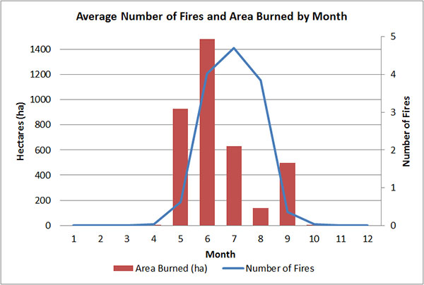
The majority of fires in WCSS occur in July; however the majority of the area burned is a result of fires that start in May and June (Figure 1). This is a result of seasonal patterns of fire weather and seasonal vegetation changes that affect forest fuel flammability.
Figure 1. Average number of fires and area burned by month within the WCSS
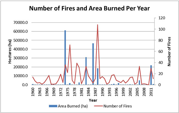
Like most boreal fire regimes, this area is subject to extreme inter-annual variability in both the number of fires and area burned per year (Figure 2). The fire cycle (the number of years required to burn over an area equal to the area of interest) of the site is challenging to estimate for WCSS. Typically, estimates of fire cycle are based on detailed forest inventory showing the age of forests or times since disturbance. As these products are not available for much of the site, estimates of fire cycle for the WCSS area is assumed to be 50-100 years.
Figure 2. This graph shows the number of fires and area burned per year between 1960 and 2011 within the WCSS
Changes to the fire regime
Forest fire management began in the 1920's with the beginning of organized fire suppression. Since the 1940's, when technology allowed humans to effectively control fire, the main approach to forest fire management has been to suppress it (Heinselman, 1996).
Under the previous Forest Fire Management Strategy for Ontario in 1988, WCSS fell within the Measured Fire Protection Zone. Within this zone, fires generally received an aggressive initial attack unless resources were unavailable due to resource requirement in the surrounding Intensive Fire Protection Zone.
In the 2004 Forest Fire Management Strategy for Ontario WCPP was part of the Parks Fire Management Zone which was created to recognize fire as an essential ecological process fundamental to ecosystem health and sustainability. Woodland Caribou Park Additions, Eagle-Snowshoe Conservation Reserve, Pipestone Bay-McIntosh EMA, and Woodland Caribou Forest Reserve fell within the Boreal and Northern Boreal Fire Management Zones. A main priority for these zones was to protect current and future wood supply. These zones also recognize the ecological role of fire in hazard reduction, as well as maintenance of ecosystems and critical habitat.
The Wildland Fire Management Strategy (2014) replaces the Forest Fire Management Strategy for Ontario (OMNR 2004) and moves away from the previous zone-based approach to one where each wildland fire is assessed independently and receives appropriate response according to the circumstances (OMNRF 2014).
Fire response activities for all fires that occur within WCSS are currently directed through the Woodland Caribou Signature Site Fire Response Plan (2010). Under the 2010 WCSS Fire Response Plan all fires in the WCSS receive full suppression. If AFFES resources are limited at the time, modified or monitored response may be used.
Ecological impacts
As a result of aggressive fire suppression, the influence of fire in WCSS's forest ecosystems has decreased. This has generally resulted in longer fire cycles and older forests (Ward and Tithecott, 1993; Ward et. al., 2001).
Quantifying the effects of fire suppression on the natural fire regime in WCSS is extremely challenging. In the past there was not a focus on data collection. This makes any estimation of the fire regime characteristics prior to modern fire management very difficult. In addition, the high inter-annual and decadal variation in area burned and number of fires makes analyzing the effect of fire management actions also very difficult. However, in the absence of any reliable studies, it is safe to say that fire suppression in WCSS has had some effect of reducing the area burned and lengthening the fire cycle. It is not thought that there have been significant changes to species composition or forest type within the signature site due to fire suppression at this time.
Risk assessment
Fuels assessment
Fuel type and condition will determine the rate and direction of fire spread. Wind is the dominant agent facilitating the spread of fire in the boreal forest, although fire spreads by conduction and convection up slopes (Johnson, 1992). The intensity of both surface and crown fires is affected by the amount and distribution of fuel available, soil and other factors, including: time elapsed since the last fire (or the amount of fuel accumulated); weather, particularity wind and degree of moisture in the vegetation; forest management activity; extent of damage or mortality caused by disease and insect infestation; species composition and stand age; and, in the longer term, climate (Thompson, 2000).
The major fuel complex within the signature site is jack pine mixed with black spruce on shallow to moderately deep soils. Mature and immature pure jack pine stands are the result of stand replacing wild fire. These two species are the primary fire carriers within the signature site. Balsam fir, jack pine, black spruce and trembling aspen characterize the upland sites and black spruce and tamarack are found on the lowlands. Fuel loading varies from site to site depending on the last fire return interval. Immature jack pine and balsam fir in the understory will contribute to fire spread by allowing fire into the crowns resulting in a crown fire. As described in the Canadian Forest Fire Behavior Prediction System (Forestry Canada Fire Danger Group, 1992) Boreal Spruce (C2) has a continuous feather moss or lichen on the forest floor, continuous shrub (i.e. Labrador tea and low to moderate downed woody fuels with deep compact organic layers of soil), while Jack Pine (C3) will have continuous feather moss on the forest floor, a moderately deep compacted organic layer, with sparse understory and sparse downed woody fuels growing on well drained upland sites. The immature jack pine (C4) will provide a continuous fuel load and have potential to develop into an intense crown fire when pushed by little wind. Balsam fir that is alive or dead in the understory will also lead to increased fire in the understory thus climbing into the crowns resulting in a sustained crown fire.
Portions of the signature site with deeper soils, mainly along the river systems, are composed of poplar, white birch and various shrub species in the understory. Fire in this fuel complex will result in a slower moving less intense fire.
Hazardous fuels are found throughout the signature site in varying degrees. Hazardous fuels are made up of a combination of weather and insect damaged fuels. Weather damaged fuels are a result of severe winds causing the forest to blow down, or heavy snow or rain causing trees to be broken or pushed to the ground in varying degrees. Increased fuel availability may result in fires burning with greater intensity and severity. In particular, jack pine budworm and spruce budworm outbreaks have the greatest impacts on fuel conditions and affect fire behavior.
In the fall of 2012, a single event that took place in the early fall referred to as "snow down "created a large storm damaged fuel complex. Estimates from general mapping in the area indicate approximately three quarters of the signature site was damaged by this single event. The Fire Program has developed a "Weather Damaged Fuels Hazard Rating System" to help classify weather damaged fuel based on evaluating and summing the scores of five criteria: foliage condition, continuity, species, anti-fuels and bole contact with the ground. In addition to this event there are numerous stands that have been damaged by insects as well as many smaller blow down events over the last few years.
In addition to this event there are numerous stands that have been damaged by insects as well as many smaller blow-down events over the last few years.
Values potentially impacted by fire
While allowing natural cycles and processes to occur is the main goal within the WCSS, human influences have created a variety of values for which it is necessary to provide protection. Life and property are the two main values that are highest priority in fire management. WCSS provides recreational opportunities through backcountry paddling, fly-in fishing, and recreational camp use. Evacuations may be necessary due to the threat of fire or smoke. Portions of the WCSS may be temporarily closed to visitors to ensure public safety. It is important for paddlers to provide trip routes to park staff or outfitters to aid in any potential evacuation or closures. Private recreation camp holders and tourist outfitters should be aware that smoke or fire could influence their business or recreational opportunities. When a fire is being assessed or actioned, an extensive search is conducted in the area for values not previously identified.
The objectives of the Forest Fire Management program in Ontario are to prevent personal injury, value loss, and social disruption resulting from a forest fire; and to promote understanding of the ecological role of fire and utilize its beneficial effects in resource management. The fire management program endeavours to protect identified values or otherwise mitigate the negative effects of fire on those values, within its capacity. However, wildfire is a constant threat and reality across the boreal forest. Property owners can and should do their part to protect their property or structure through mitigation activities outlined in the Fire Smart program (OMNR, 2013). This includes techniques such as removing potential fuels around a structure, creating a defendable space and using fire resistant building materials. Reducing value loss often can be greatly assisted by taking preventative measures before a fire occurs.
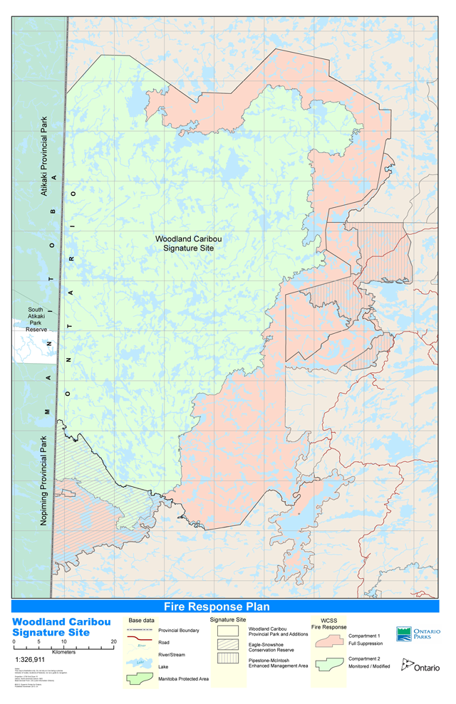
Forest management units (FMU) adjacent to the WCPP, park additions and Eagle-Snowshoe Conservation Reserve and within the Pipestone-McIntosh Enhanced Management Area are values that require protection from fire to ensure long term wood supply. To protect them, a buffer within the park and conservation reserve following its boundaries (Fire Management Compartment 1) is identified to receive full suppression of fires to prevent spread into surrounding FMUs (see Appendix C). This boundary generally follows systems of water bodies, which can be used during fire management operations as defensible boundaries. If risk of spread from the modified fire response zone of the WCSS to surrounding FMUs is too great, due to conditions at the time, AFFES has the option to use full suppression within the modified fire response zone. Fires in the Pipestone-McIntosh EMA and Woodland Caribou Forest Reserve sections of the WCSS are identified to receive a full response to protect wood supply and other values in and around those areas.
Current and future woodland caribou winter habitat is also a value in WCSS and maintaining it is an objective of the area. Ensuring Ecological Integrity within the WCSS involves looking at the ecosystem at a landscape level and management needs across administrative boundaries. The MNRF has adopted a range management approach to caribou conservation. Integrated range assessment reports evaluate habitat conditions, population trends, and cumulative impacts and relate these to measurable indicators of population health or habitat status. The range assessment approach provides spatial and ecological context, as well as recommendations for planning and management decisions. WCSS provides habitat for both Berens and Sydney caribou ranges. The Sydney Range is at the southern extent of the identified current caribou range and has been greatly influenced by a wide variety of natural and anthropogenic disturbances. The combination of population size and trend, as well as habitat condition and arrangement, show that the Sydney Range is unlikely to support caribou unless conservation measures are implemented (OMNR, 2013a). Caribou occupancy of the Sydney Range is primarily within the WCSS where human disturbance is low and significant winter habitat exists (OMNR, 2013a). It has been proposed that more aggressive fire suppression is warranted within some areas of the Sydney Range (OMNR, 2013a). It will be important to protect habitat and provide full suppression in the face of large fire events to ensure there is a suitable supply of year-round caribou habitat (OMNR, 2013a), particularly winter habitat. A detailed description and map of how the full suppression boundary was formed based on current and future caribou habitat and use within the WCSS is provided in Appendices D and E.
A list of all values and fire’s potential effect is provided in the Woodland Caribou Signature Site Vegetation Management Plan Background Information and Options (OMNR 2012). Only the values addressed by goals and objectives of this plan are described in detail above.
Goal and objectives
- Protect human life, value loss and social/economic disruption from forest fires
- Follow AFFES standard operating procedures and strategies
- Reduce hazard fuels caused by insect infestation or weather events if required
- Protect long term wood supply in forest management units
- Maintain and restore Ecological Integrity (EI) within WCSS
- Promote the ecological role of fire within the WCSS using fire response (e.g. modified response and monitoring) and fire use options (e.g. prescribed burning)
- Maintain species at risk (SAR) populations and their habitat (current and future), with specific consideration of the population of woodland caribou which is at the southern extent of Ontario’s current identified range
- Examine current caribou habitat in greater detail (forest age, productivity, lichen abundance) and determine a more refined estimate of forest ages that provide important winter habitat
- Provide full suppression fire response within certain areas to maintain important caribou winter habitat
- Provide habitat for wolverine by managing for woodland caribou
- Promote research within WCSS to follow an adaptive management framework
- Monitor fire effects at different temporal and spatial scales to continually refine fire objectives in WCSS in terms of maintaining ecological integrity
- Ensure education occurs on the importance of fire management within the WCSS
- Liaise with adjacent partners and stakeholders
- Promote education of fire management within the WCSS
- Develop education aids
Fire management options
Description of fire management options
All fires in the signature site will receive a response to prevent personal injury, value loss and social disruption, while also considering the predicted behaviour of that fire, the potential impact on persons, property and values; and the estimated cost of the response. All fire operations, including monitored or modified response will be in accordance with Aviation, Forest Fire and Emergency Services policies and protocols.
During periods of escalated fire activity, the availability of fire management resources may be limited. Senior fire program managers in consultation with the District Manager and the Park Superintendent may need to prioritize fires for initial response and/or sustained action. Approved Fire Assessment Reports will be used to help prioritize fires and identify the appropriate response option.
Full response
Full response of forest fires includes immediate, aggressive initial attack and/ or sustained suppression action until the fire is declared out. Total fire suppression within WCSS does not realize Ontario’s Wildland Fire Management Strategy objective of promoting the ecological role of fire and utilizing its beneficial effects in resource management. It is also contrary to wilderness park objectives. However, where public safety, property or other values are threatened within or outside WCSS, a full response will be initiated.
Monitored response
A monitored fire response involves the assessment, observation and periodic re-assessment of a fire to allow the fire to achieve ecological or resource management objectives while ensuring social disruption and/ or negative impacts to significant values and resources are minimized. Monitoring has been a tool used by park and fire managers since the implementation of WCSS's first Fire Response Plan in 2005. This fire response option provides a viable opportunity to partially restore fire as an ecosystem process within WCSS's boundaries at a very broad scale.
Modified response
Modified response uses a combination of suppression and fire management techniques including direct and indirect attack (e.g., burning out) to steer and contain the fire within a predetermined perimeter. Modified response opportunities allow suppression action to be taken on key areas of the perimeter of a fire to minimize negative impacts while still achieving the desired ecological objective for the fire where safe and achievable. Modified response is a valid opportunity to contribute to the restoration and maintenance of fire dependent ecosystems within WCSS. Modified response may also include monitoring a fire. This response option balances the ecological objectives for managing the fire while minimizing the negative impacts associated with allowing a fire to burn.
Prescribed burning
Prescribed burning is the deliberate, planned and knowledgeable application of fire by authorized personnel to accomplish pre-determined forest management or other land use objectives within a specific area.
Prescribed burning is an option that will provide WCSS staff the opportunity to maintain and restore ecological integrity, and/or meet hazard reduction objectives within the WCSS. This opportunity may be used in areas where monitoring or modified response may not be feasible (e.g. near WCSS boundary, adjacent to structural or community values) or in areas where a very specific outcome is desired. Prescribed burns will conform to the Prescribed Burn Planning Manual and require their own plans.
Prescribed fire
Prescribed fire describes forest fires deliberately utilized in a predetermined area in accordance with pre-specified and approved burning prescription to achieve pre-set objectives. Prescribed fire is a useful management tool when trying to achieve specific outcomes that result only from specific types of fires. For example, regenerating red and white pine stands can require surface fires which remove competing surface vegetation and prepare seedbeds without killing adult trees. Using prescribed fire with a set prescription will only allow those types of surface fires to burn, fires that are either not intense enough to achieve the desired results, or so intense they would kill the mature trees would be suppressed. Essentially prescribed fire allows fires to burn only in a specific window of conditions to achieve very specific objectives.
Due to frequent fires in the WCSS and the short history of fire suppression, there are not thought to be large impacts to vegetation communities in the signature site because of a lack of fire. Therefore prescribed fire will not be a fire response option necessary to meet ecological objectives. The objectives of WCSS are to have a naturally functioning fire regime, where safe and achievable. A natural fire regime consists of low and high-intensity fires as well as surface and crown fires. Restricting the types of fires allowed to burn based on a set prescription would not allow a natural fire regime.
Different combinations of fire response and fire use options were considered for the WCSS and discussed in Woodland Caribou Signature Site Vegetation Background Information and Options (2012). The following section outlines the preferred fire management approach for WCSS.
Preferred fire management option
The preferred fire management approach in WCSS is to use a combination of fire response options (full, modified, monitored) to allow fire to function naturally in the signature site, where safe and desirable. Fires which threaten life, property, and other identified values will be supressed. All fires in the signature site will receive a response commensurate with values at risk, fire program capacity, and the preferred response option as identified in this plan. Prescribed burning will be considered and used where appropriate, however is not a primary fire management option. Prescribed burns will be assessed and planned individually following MNRF policies and procedures. Prescribed fire will not be used. A detailed description and map of how the full response boundary was formed based on current and future caribou habitat and use within WCSS is provided in Appendix E and F.
The preferred approach described here was not a detailed approach outlined in the WCSS Vegetation Management Plan Background Information and Options. This approach was chosen as it was considered the best balance of allowing fires to function naturally, while still ensuring species at risk habitat and preventing spread of fire into forest management units. Full response, modified response, modified response, and prescribed burning were chosen as preferred responses to allow flexibility in achieving goals and objectives. Cons associated with the preferred approach include: does not allow fire to function naturally throughout the entire WCSS, increased cost to AFFES, and may have increased impact on social disruption within and adjacent to WCSS.
Fire management direction
Fire management compartments
To assist AFFES fire managers, WCSS has been divided into two fire management compartments to identify the preferred fire management approach (see Appendix C). Boundaries of each fire compartment may change within the term of this plan in response to new information or landscape changes, to ensure objectives are being met.
Fire management compartment 1
Fire Management Compartment 1 occupies approximately 237,535 hectares of the signature site. Fires occurring within this compartment are associated with a significant risk of escape due to the proximity of the compartment to the boundary of the site. Fires in this compartment may also have the greatest potential to cause social disruption or adversely affect wood supply, future resource allocations, or other values adjacent to the site. This compartment also contains significant woodland caribou habitat requiring protection from fire (see Appendix D and E). Fires within Fire Management Compartment 1 will be assigned the highest priority for fire suppression within the WCSS.
Fires will receive full response within program capacity and safety considerations. Sustained action, if required, will be determined through the approval of a Fire Assessment Report. Suppression action will be undertaken to minimize the risk to values and to minimize disturbance in areas identified as caribou habitat. Prescribed burns may occur in this compartment.
Fire management compartment 2
Fire Management Compartment 2 encompasses approximately 309,898 hectares of the signature site (Appendix C). The preferred response option in this compartment is a Monitored or Modified response. This will help to allow natural fire to occur within the signature site. Where the action will not directly threaten any known values, and it can be safely done, AFFES will endeavour to provide a Modified or Monitored response to lightning-caused fires in this compartment. Fires resulting from human activity are not considered natural fires in the signature site. Suspected person-caused fires will receive a full response if they can be immediately assessed as such. Fires which cannot immediately be determined as human caused will receive a monitored/modified fire response.
The full range of response options (full, modified, monitored) may be considered for use in Fire Management Compartment 2 based on individual assessments and fire management program capacity, however the preferred response is monitored or modified. Prescribed burns may occur in this compartment.
Fire operations
Implementation of this plan will be guided by standard operating procedures of MNRF to safeguard public health and safety, minimize socio-economic impacts and protect property and values. The protection of human life and property is a priority of fire management in the province. Any fires that threaten human life, property or values will receive a response commensurate with the risk to prevent harmful effects and minimize the disruption of socio-economic activities.
The Park Superintendent, District Managers and the Fire Management Supervisors will cooperate in the implementation of the plan through annual preparedness planning and communication throughout the fire season and during fire events. Preparedness planning will include review and update of any operational, communications or emergency response plans, as well as the identification of specific roles and responsibilities.
Ontario maintains a Quick Strike agreement with Manitoba which allows Ontario and Manitoba fire management resources to respond to fires up to 8km inside the border of the other province. The Manitoba fire management agency will be made aware of the preferred fire response in each compartment of the signature site within 8km of the provincial border to inform and direct any future cross-border fire response under the agreement.
Minimum impact suppression techniques
Aviation and Forest Fire and Emergency Services will endeavour to minimize the negative impacts of all its activities by using "Light on the Land" fire management techniques within the WCSS wherever feasible. These techniques help to reduce the footprint on natural and cultural values, as well as to reduce impacts on aesthetics. This is particularly important within a protected area which is managed to ensure ecological and cultural integrity, and promote wilderness quality for backcountry visitors. "Light on the Land" fire management techniques include, but are not limited to:
- Using natural clearings or openings for helipads, staging centres, or fire camps
- Situating sites associated with fire operations away from canoe routes or private cottages and commercial tourism facilities if possible
- Minimizing trees felled at fire operations camps
- Removing and dismantling any structures made
- Removing all equipment
- Removing all waste material relating to fire response activities, including hazardous materials
The Parks office will provide Fire Management Headquarters with sites of significant or sensitive ecological or cultural value where sites associated with fire operations should not be located.
Monitoring
It will be necessary to monitor the effectiveness of the vegetation management plan to determine if ecological and cultural integrity goals are being achieved. As this plan follows an adaptive management approach, ecological and operational post fire monitoring will contribute to ongoing fire management decisions within the signature site. Progressively more protected areas, as well as other parts of the province, are moving away from full suppression-only techniques and are recognizing fire’s importance on the landscape. Pre-fire stand conditions will be determined through a combination of aerial photography, fire monitoring flights, and ground plots immediately outside of the fire perimeter.
Post-fire monitoring will help provide direction on the balance between fire, caribou habitat and effective management. It will also be important to work with First Nations communities and the public when monitoring and reviewing our management decisions. Post fire surveys of past stand replacing fires as well as those occurring in the coming fire seasons will be completed. This will help aid in the determination and forecasting of what type of burns occur on different forest types during different weather indices. In the future this will contribute to fire management decisions about protection of life, property, and park values, as well as help meet natural fire objectives. It will also help determine if the large stand-replacing fires, characteristic of a prairie influenced boreal forest, are occurring, or if ecological integrity goals are not being met due to safety concerns. Post fire surveys will measure tree and vegetation remnants, duff consumed, mineral exposure, canopy cover, seed sources, etc. This will provide information on the burn severity and intensity, as well as expected vegetation regeneration. Continued conversations with AFFES about type of burn, behaviour observed, and how a fire was actioned, will contribute to fire operations monitoring. As fire regime and forest succession patterns occur over time, it will be important to utilize any historical data sources, as well as maintain post-fire surveys.
When the enhanced Forest Resource Inventory is available for the entire WCSS area, modelling may help to determine if the signature site is within the Simulated Range of Natural Variation (SRNV) of forest age and type. This will assist in caribou habitat management, in providing sufficient winter habitat. Over time it will be necessary to adjust the full suppression areas as caribou winter habitat changes in suitability. Ground truthing forest stands to measure structure, as well as terrestrial and arboreal lichen abundance will help with mapping potential caribou habitat and any future amendments of compartment fire boundaries. As the high levels of fire activity and variability in the signature site adds a higher level of uncertainty to the outcome of all planned habitat management efforts (OMNR 2013b), it will be necessary to review full suppression boundaries annually based on fire activity and risk to values. Parks staff will continue to work with Manitoba government, as well as District and Regional biologists to ensure adequate caribou habitat and planning is provided for through the implementation of the approved WCSS Vegetation Management Plan.
As wild rice management and First Nations customary burning are traditional activities, monitoring these goals and objectives will involve communicating with communities who have traditional land use within WCPP. Ontario Parks will document which communities are approached and if there is interest to discuss educational aids and learning opportunities for park staff and the public on cultural vegetation management.
Campsite and portage conditions are reviewed on a yearly basis as information becomes available from the year’s operating season. This helps to inform maintenance and management priorities for the following year. Ontario Parks staff complete campsite and portage conditions forms on regular park trips. Information collected from park visitors also contribute to documented conditions. This assists in determining visitor impact over time through loss of vegetation, erosion, or compaction.
If the presence of a non-native or invasive species becomes known, an action plan will be developed if required. Park staff will be encouraged to report on non-native species while completing campsite and portage forms. Training for staff on the identification of plant species will be provided.
Monitoring will include assessing if education and awareness tools were effectively provided for park visitors about vegetation management within the park (e.g. natural fire cycles and ecology, invasive species, and light on the land practices).
Relationship to Class Environmental Assessment
When the Ministry of Natural Resources and Forestry considers undertaking activities, an assessment of the projects is required under the Environmental Assessment Act (EAA). To comply with EAA MNRF has two class environmental assessments (Class EA), which are efficient and effective approaches applied to groups of projects that have common attributes, qualities, or characteristics. A class EA allows MNRF to assess projects according to their similar scale, potential environmental effects and/or level of concern of interested persons, government agencies, and Aboriginal communities. When a project is proposed, the project is put through a series of considerations, called a screening. The screening identifies net negative or positive environmental effects and potential levels of concern. Based on the screening results, MNRF then assigns a project to one of four categories (A, B, C, D) which determines the level of detail and consultation required to evaluate projects.
There are some projects that the MNRF carries out which have been pre-assigned as a Category A projects. Generally no formal public consultation is required for Category A projects , although some projects may require notification. Also MNRF may discuss projects and information with First Nations and potentially affected parties. MNRF maintains a list of pre-assigned Category A projects in the two Class EAs:
- For projects within protected areas: A Class Environmental Assessment for Provincial Parks and Conservation Reserves
- For projects on other Crown lands: A Class Environmental Assessment for Resource Stewardship and Facility Development
The Woodland Caribou Signature Site Vegetation Management Plan provides direction for many projects that are subject to the Class EA-PPCR or Class EA-RSFD. The implementation of projects in Woodland Caribou Signature Site will comply with the requirements of a Class EA-PPCR and Class EA-RSFD. This may include further opportunities for consultation, as required.
Examination and adjustment of management direction
This vegetation management plan will be examined at the same time as the Woodland Caribou Provincial Park Management Plan and the Eagle Snowshoe Conservation Reserve Resource Management Plan to determine whether it is still relevant, effective and current or if adjustments are needed. The projects within will be examined to determine if any modifications to the vegetation/fire management plan are necessary. The examination will take into consideration any new environmental conditions, new government policies or new technologies for mitigating environmental effects; the results of any monitoring and reporting; and any specific comments received during the timeframe of the plan. The results of the examination may require that a new vegetation/fire management plan be prepared or that this vegetation/fire management plan be adjusted. Any adjustments will be assessed to determine documentation and consultation requirements under the Class EAs.
Consistent with an adaptive management framework, approaches and outcomes may be adjusted within the term of the plan in response to monitoring results or new information. Fire managers, the Superintendent, the District Managers and protected area staff may propose changes to this vegetation/fire management plan at any time to ensure that the specified objectives are being met or are consistent with management direction.
External requests for adjustments to address specific proposals or needs may be considered. Ontario Parks/MNRF can provide further guidance on the process for requesting an adjustment and whether specific requests can/will be considered. New projects will be screened for environmental effects and aboriginal/public/agency interest to determine how the plan may be adjusted. Adjustment procedures are described in the Ontario’s Protected Areas Planning Manual.
References
Boyce, B. 2012. 2012-2022 Forest Management Plan for the Kenora Forest. Miisun Integrated Resource Management Inc. on behalf of Miitigoog LP.
Carpenter, Eli. 2009. Personal communication. Wabaseemoong First Nation.
Davidson-Hunt, Iain., and Miller. A. M. 2010. Fire, Agency and Scale in the Creation of Aboriginal Cultural Landscapes. Human Ecology: 38:401-414
Forestry Canada Fire Danger Group. 1992. Development and structure of the Canadian Forest Fire Behavior Prediction System. Forestry Canada, Ottawa, Ont. Inf. Rep. ST-X-3.
Heinselman, M. L. 1981. Fire intensity and frequency as factors in the distribution and structure of northern ecosystem. In Fire Regimes and Ecosystem Properties H. A.
Heinselman, M. 1996. The Boundary Waters Wilderness Ecosystem. University of Minnesota Press.
Johnson, E.A. 1992. Fire and Vegetation Dynamic: Studies from the North American Boreal Forests. Cambridge, Cambridge University Press.
Johnson, E.A. and K. Miyanishi. 1995. The need for consideration of fire behavior and effects in prescribed burning. Restoration Ecology, 3: 271-278
Land, George. 2006. Personal communication. Wabaseemoong First Nation.
Leighly, J. (ed.) (1963). Land and life: A selection from the writings of Carl Ortwin Sauer. Berkeley: University of California Press, p. 343
Lewis, H.T. 1982. A time for burning. Occasional Publication Number 17. Boreal Institute for Northern Studies, University of Alberta.
Lewis, H.T. 1977. Muskuta: the ecology of Indian fires in Northern Alberta. Western Canadian Journal of Anthropology 7: 15-52.
Manitoba Conservation. 2011. Action Plans for Boreal Woodland Caribou Ranges in Manitoba. Draft. 53 pp.
Manitoba and Ontario. 2008. Memorandum of Understanding Interprovincial Wilderness Area Agreement. Toronto, Queen’s Printer.
Miller, A. 2008. Lessons in Fire Ecology and Fire Safety. Whitefeather Forest Management Corporation.
Ontario Ministry of Natural Resources. 2011. Prescribed Burning Operations Policy (AFFES:FM:2:10). Toronto, Queen’s Printer.
Ontario Ministry of Natural Resources. 2013. Be FireSmart. Toronto. /page/emergency-preparedness
Ontario Ministry of Natural Resources. 2013a. Integrated Range Assessment for Woodland Caribou and their Habitat: Sydney Range 2012 (Draft). Biodiversity and Monitoring Section, Peterborough, Ontario.
Ontario Ministry of Natural Resources. 2013b. Integrated Range Assessment for Woodland Caribou and their Habitat: Berens Range 2012 (Draft). Biodiversity and Monitoring Section, Peterborough, Ontario.
Ontario Ministry of Natural Resources. 2012. Woodland Caribou Signature Site Vegetation Management Plan Background Information and Options. Ontario Parks. 55 pp.
Ontario Ministry of Natural Resources. 2010. Woodland Caribou Signature Site Fire Response Plan. Toronto, Queen’s Printer.
Ontario Ministry of Natural Resources. 2009. Ontario Protected Areas Planning Manual. Peterborough. Queen’s Printer for Ontario. 50 pp.
Ontario Ministry of Natural Resources. 2009b. Caribou Conservation Plan. Toronto, Queen’s Printer.
Ontario Ministry of Natural Resources. 2007. Woodland Caribou Signature Site Management Plan. Ontario Parks, Ontario. Toronto, Queen’s Printer.
Ontario Ministry of Natural Resources. 2007a. Endangered Species Act. Toronto. /laws/statute/07e06
Ontario Ministry of Natural Resources. 2007b. Eagle-Snowshoe Conservation Reserve Resource Management Plan. Toronto, Queen’s Printer.
Ontario Ministry of Natural Resources. 2007c. Pipestone Bay-McIntosh Enhanced Management Area Resource Management Guideline. Queen’s Printer.
Ontario Ministry of Natural Resources. 2006. Provincial Parks and Conservation Reserves Act. Toronto. /laws/statute/06p12
Ontario Ministry of Natural Resources. 2005. A Class Environmental Assessment for Provincial Parks and Conservation Reserves. Queen’s Printer for Ontario. Toronto.
Ontario Ministry of Natural Resources. 2004. Forest Fire Management Strategy for Ontario. Toronto, Queen’s Printer.
OMNR. 2003. A Class Environmental Assessment for MNR Resource Stewardship and Facility Development Projects. Queen’s Printer for Ontario. Toronto. 80pp.
OMNR. 1990. Forest Fires Prevention Act. Toronto.
OMNRF. 2014. Wildland Fire Management Strategy. P00464 Toronto: Queen’s Printer for Ontario.
Parks Canada. 2009.
http://www.pc.gc.ca/eng/pn-np/mtn/feuveg-fireveg/dirige-prescribed/role.aspx
Parks Canada. 1994. Guiding Principles and Operating Policies. Ottawa: Department of Canadian Heritage. Link: http://www.pc.gc.ca/docs/pc/poli/princip/gloss.aspx
Pikangikum First Nations and Ontario Ministry of Natural Resources. 2006. Keeping the Land – Whitefeather Land Use Strategy.
Ranta, B. 2001. Report on Woodland Caribou and their Use of Habitats in the Kenora Management Unit and Southern Portions of Woodland Caribou Provincial Park. OMNR. Kenora, Ontario. 18 pp.
Sauer, C. O. 1925. The Morphology of Landscape. University of California Publication in Geography 2(2): 19–54.
Thompson, I. D. 2000. Forest vegetation of Ontario: factors influencing landscape change. Pp. 30-53 in Perara, A., D. Euler, and I. Thompson (eds.). Ecology of a managed terrestrial landscape: patterns and processes of forest landscapes in Ontario. The University of British Columbia Press, Vancouver, BC.
Van Sleeuwen, M. 2006. Natural Fire Regimes in Ontario. Ontario Ministry of Natural Resources, Queens Printer for Ontario, Toronto 143p.
Vennum, T. 1988. Wild Rice and the Ojibway People. Minnesota Historical Society Press. St. Paul, MN.
Ward. P.C., A.G. Tithecott, and B.M. Wotton. 2001. Reply – A re-examination of the
effects of fire suppression in the boreal forest. Canadian Journal of Forest Research, 31: 1467- 1480.
Ward, P.C., and A.G. Tithecott. 1993. The impact of fire management on the boreal landscape of Ontario. Aviation, Flood and Fire Management Branch Publication No. 305. Ont. Min. Nat. Res., Queens Printer for Ontario, Toronto, Canada.
Whitefeather Forest Management Corportation. 2006. Keeping Woodland Caribou on the Land: Cross- Cultural Research in the Whitefeather Forest (Draft).
Glossary of terms
Many of the terms listed are found in the 2000 Glossary of Forest Fire Management Terms (Canadian Interagency Forest Fire Centre CIFFC) and the Forest Management Planning Manual (OMNR). Other terms included are as generally accepted and understood in the Ontario Ministry of Natural Resources.
Backfiring (Backfired)
A form of indirect attack where extensive fire is set along the inner edge of a control line or natural barrier, usually some distance from the wildfire and taking advantage of in drafts, to consume fuels in the path of the fire, and thereby halt or retard the progress of the fire front.
Burning Out (Burnout)
A fire suppression operation where fire is set along the inside edge of a control line or natural barrier to consume unburned fuel between the line and the fire perimeter.
Detection
A system for or the act of discovering, locating and reporting forest fires.
Direct Attack
A method whereby the fire is attacked immediately adjacent to the burning fuel (Note: This is generally accomplished by the individual or combined use of aircraft, hose, pumps and hand tools to extinguish the fire. Primarily used when the fire management objective is to minimize area burned).
Ecosystem
A biological community of interacting organisms and their physical environments.
Ecosystem Renewal Area Burned
Areas that burn and do not impact wood supply. This includes islands, parks and protected areas such as Provincial Parks and Conservation Reserves, and remote areas in the northern portion of the province.
Fire Assessment Report (FAR)
A report prepared by the Incident Commander, which is a collection of Fire Impact Assessment information in standard format, for consideration by the Fire Region for priority setting and further analysis. The analysis leads to a decision to establish a priority for fires and to maintain, increase, decrease or discontinue the fire suppression effort such that costs and/or damage are minimized, and/or benefits from the fire are maximized.
Fire Behaviour
The manner in which fuel ignites, flame develops, and fire spreads and exhibits other related phenomena as determined by the interaction of fuels, weather, and topography.
Fire Cycle
The average number of years required to burn an area equal to the total area of interest.
Fire Intensity
The rate of heat energy released from a flaming fire front per unit time per unit length of flame front.
Fire Load
The number and magnitude (i.e. fire size class and fire intensity) of all fires requiring suppression action during a given period within a specified area.
Fire Management
The activities concerned with the protection of people, property, and forest areas from wildfire through managed fire response, and the use of prescribed fire for the attainment of forest management and land management goals and objectives, all conducted in a manner that considers environmental, social and economic criteria.
Fire Management Zone
A geographic area characterized by similar forest types and fire loads and by similar impacts of fires on society, wood supply, tourism, and the ecosystem.
Fire Prevention
Activities directed at reducing fire occurrence; includes public education, law enforcement, personal contact and reduction of fire hazards and risks
Fire Protection
In fire management, it is the aggregate amount of fire management activity that is applied to a management area (see level of protection).
Fire Regime
The kind of fire activity or pattern of fires that generally characterize a given area.
Fire Season
April 1 to October 31 of each year as defined by the Forest Fire Prevention Act (FFPA).
First Nation
A community as defined by the Indian Act (Canada).
Forest Fire
Any fire burning in forested areas, grass, or alpine/tundra vegetation ---synonymous with Fire.
Forest Fires Prevention Act (FFPA)
An Act of the Ontario legislature that mandates the Minister of Natural Resources to provide forest fire protection in the fire region of Ontario as defined by the FFPA.
Fuelbreak
An existing barrier or change in fuel type (to one that is less flammable than that surrounding it), or a wide strip of land on which the native vegetation has been modified or cleared, that act as a buffer to fire spread so that fires burning into them can be more readily controlled. Often selected or constructed to protect a high value area from fire. In the event of fire, may serve as a control line from which to carry out suppression operations.
Fuels
Wildland vegetation materials that can burn. While usually referring to aboveground living and dead wildland surface vegetation, roots and organic soils such as peat often are included.
Fuel Management
The planned manipulation and/or reduction of living or dead forest fuels for forest management and other land use objectives (e.g. hazard reduction, silvicultural purposes, wildlife habitat improvement) by: prescribed fire; mechanical, chemical, or biological means; and/or changing stand structure and species composition.
Hazard Reduction
A treatment of dead or dying forest fuels to diminish the chance of fire starting, and to lessen the potential rate of spread and resistance to control.
Hazard Reduction Area Burned
Areas burned that are dead or dying as a result of insect infestations such as the spruce budworm or areas that have blown down. These areas will be identified by resource managers as candidate areas for Modified Response in an effort to return fuel conditions to fire origin species
Human-Caused Fires
A forest fire or wildfire caused by human carelessness, human activities or malicious use of fire.
Indirect Attack
A method whereby the control line is strategically located to take advantage of favourable terrain and boundaries in the advance of the fire perimeter and the intervening strip is usually burned out or back burned. The fire management objective is to extinguish, control or steer a fire to optimize the area burnt for ecological, fuel reduction or silvicultural purposes.
Initial Attack
The action taken to halt the spread or potential spread of a fire by the first fire fighting force to arrive at the fire.
Level of Protection
The amount of effort that a fire management organization is willing to expend to respond to forest fires based upon the organization’s land and resources management objectives.
Light on the Land
Non-destructive methods of fire suppression, which do not unduly disturb the landscape and ecosystem.
Managed Fire
Any fire managed using full, modified or monitored response or a combination of response options to meet fire or resource management objectives - such that costs and/or damage are minimized and/or benefits from the fire are maximized.
Modified Response Fire
A fire that is managed using a combination of suppression techniques, including direct and indirect attack as well as monitoring to steer, contain or otherwise manage fire activity within a predetermined perimeter such that costs and/or damage are minimized and/or benefits from the fire are maximized
Monitored Response Fire
A fire that is observed and assessed to determine the response option required to minimize social disruption and/or significant value and resource impacts while achieving beneficial ecological, economic or resource management objectives.
Objective
An object of action. An end as a cause of action
Prescribed Fire
Forest fires deliberately utilized in a predetermined area in accordance with a pre-specified and approved burning prescription to achieve preset objectives.
Prescribed Burning
The deliberate, planned and knowledgeable application of fire by authorized personnel and in accordance with MNR policy and guidelines to a specific land area to accomplish pre-determined forest management or other land use objectives.
Strategy
The means or steps of achieving an objective.
Suppression
All activities concerned with controlling and extinguishing a fire following its detection.
Sustainable Forest License (SFL)
Under the Crown Forest Sustainability Act, a Sustainable Forest License is a renewable license to harvest forest resources in a management unit that requires a licensee to carry out renewal and maintenance activities necessary to provide for the sustainability of the Crown forest in the area covered by the license. This type of license may be granted for up to 20 years (CFSA).
Sustained Attack
Conducting fire suppression action on a wildfire for an extended period of time.
Values
The specific or collective set of natural resource and human-made development/improvements that have measurable or intrinsic worth and that may be destroyed or otherwise altered by fire in any given area.
Wildfire
The specific or collective set of natural resources and human-made development/improvements that have measurable or intrinsic worth and that may be destroyed or otherwise altered by fire in any given area; any unwanted forest fire.
Appendix A: Provincial/regional context
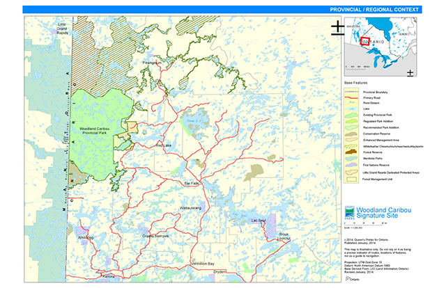
Enlarge Provincial/Regional Context Map
Appendix B: Signature site reference map
Enlarge Signature Site Reference Map
Appendix C: Fire response map
Appendix D: Caribou habitat use and planning in fire management
Because of concern for woodland caribou sustainability, particularly at the southern extent of occupancy, select tracts of caribou winter habitat will receive full suppression. Priorities involve maintaining connectivity between Ontario and Manitoba habitat, maintaining connectivity with surrounding forest management units, and reducing fragmentation of current used habitat and travel corridors. The WCSS has been divided into zones describing current caribou use and fire management direction, illustrated in Appendix E. These zones are continuously changing as the land changes both in age and disturbance activity.
Zone 1 is not a high use caribou winter habitat area at this time. There is both calving and summer use by both the Sydney range, as well as Atikaki-Berens range animals from Manitoba. It provides important summer habitat for Atikaki-Berens animals, although summer habitat is not thought to be in short supply within WCPP and can co-exist with the presence of fire. As fires within this region typically burn in a west to east pattern, it is unlikely connectivity between the Atikaki-Berens range and habitat within WCPP will be lost. The western portion of this zone is made up of a large burn from the 1940s providing summer use, but little evidence of winter use at this time. A large burn from 1970s makes up the eastern portion of this zone and appears to currently have little caribou occupation in the winter. It is possible that once the forest ages and thins that this area will be used. Both the Gammon and Bloodvein river systems are found in this zone. These systems are associated with deeper soils and greater mixedwood content. This zone is thought to be low value as winter caribou habitat at this time. As a result the desired fire response in zone 1 based on caribou habitat is modified/monitored fire response.
Caribou which use Zone 2 are part of the Berens range which winter in the northeast corner of WCPP and western edge of the Whitefeather forest. Some animals appear to head east for the summer to calve on and around Trout Lake, while others calve and spend the summer with little migration away from their wintering grounds. This zone may be particularly important to maintain when the harvesting of caribou habitat Whitefeather Forest MU occurs adjacent to the signature site. It will be important to maintain full suppression in this area until an adjacent large 1987 burn has winter habitat capabilities. Several blowdown events in the 2000s may have already caused some disruption to caribou movement in this area. This Zone also falls within the full suppression boundary of the WCSS to prevent fire spread into surrounding forest management units. Zone 2 is a heavily used caribou wintering area which will receive full suppression during the lifetime of this plan.
Zone 3 is currently used in both summer and winter by caribou, as well as hosting calving lakes. There is evidence of use around the immediate lakes across the Manitoba border. Fire suppression will maintain connectivity to Manitoba. This area is made up of a variety of forest ages, including some of the oldest forest in the park, as well as multiple burns from 1980s and 2000s, creating a patchy landscape. As it is expected that the older forest in this area will lose habitat quality characteristics, full suppression direction will be removed when adjacent '70s and '80s burns have winter habitat capabilities. The majority of this zone will receive full suppression at this time.
Zone 4, within the Sydney range, is considered prime winter caribou habitat for the next 50 years unless disturbed. It is a central location to habitat north, south, east, and west. It is particularly important in maintaining connectivity south and east to calving and nursery lakes outside of the park, in the Kenora and Whiskey Jack Forests. It will be critical in maintaining north to south movement, hopefully re-establishing use at the southern extent of continuous caribou distribution. The development of the Kenora Forest Dynamic Caribou Harvest Schedule is integral in this process. There will be no harvesting within used and potential caribou habitat until large 1980s burns in the areas become suitable (Ranta, 2001; Boyce, 2012). A complete description of caribou habitat management tracts and schedule are found in Kenora Forest 2012-2022 Forest Management Plan Supplementary Documentation N – Caribou Habitat Analysis. This zone will receive full suppression.
Zone 5 is a tract composed of a 30 year old burn which was previously caribou habitat. This area is predominantly jack pine and will expect to be caribou winter habitat in the future. It is expected that this area will self-thin and become useable habitat in the next 20 to 30 years. Full suppression is proposed to ensure habitat when currently used areas within the Sydney range age and reduce in habitat quality. A size over 20,000 ha was chosen, as this should be adequate to support winter caribou use, borders a currently used full suppression tract to the east, and includes Irregular Lake to the west, a highly used calving lake in the past.
Zone 6 was delineated to allow fire and regeneration within the Sydney range. The majority of this area is made up of the large 1980s Irregular Lake burn in the north half of the Eagle-Snowshoe CR, as well as many other small 1980s burns within 100 year old conifer forest. GPS collar data collected in 2012 and 2013 show little use of this area and a general avoidance of the younger stands. Modified/monitored is the chosen fire response for this area.
The southern half of the Eagle-Snowshoe CR will receive full suppression in Zone 7. This creates a boundary to prevent any potential fire spread to the Kenora Forest Management unit. It will also provide habitat for animals from the Owl-Flintstone range in Manitoba. The Owl-Flintstone range is assessed as at high risk of decline (Manitoba Conservation, 2011). There is a large amount of both natural and anthropogenic disturbance affecting the Owl-Flintstone range, restraining animal distribution and use of the landscape. Limiting disturbance in the south half of the Eagle-Snowshoe CR will allow any expansion or use from the Owl-Flintstone animals, as well as maintain a corridor between Owl-Flintstone and Sydney range animals utilizing the Kenora Forest.
Zone 8 has evidence of calving islands on Sydney Lake and summer use. No winter use is known to occur here, however there is extensive use to the north and west. This zone will remain as full suppression, regardless of caribou usage, as it is in close proximity to the surrounding Forest Management Units.
Zone 9 is made up of the Pipestone-McIntosh Enhanced Management Area. This EMA falls within the Red Lake Forest and caribou planning is completed through a Dynamic Caribou Habitat Schedule. A complete description of caribou habitat management tracts and schedule are found in Red Lake Forest 2008-2018 Forest Management Plan. This zone will receive full suppression.
Appendix E: Caribou use zone map
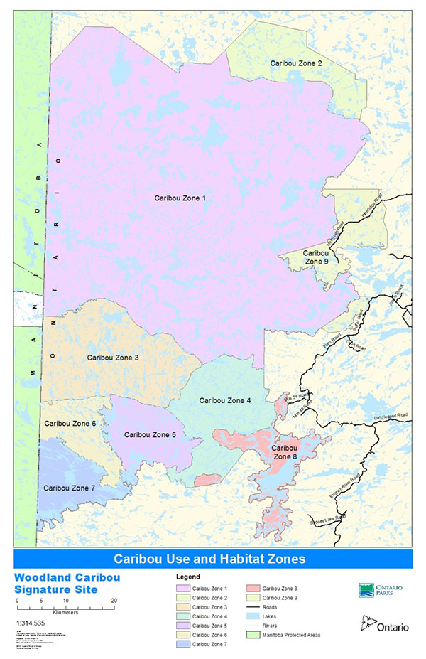
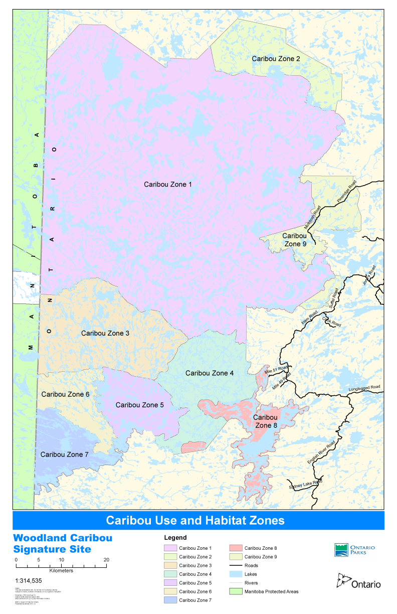
Appendix F: Summary of consultation
The planning for the Woodland Caribou Signature Site Vegetation Management Plan began in 2009 during the development of the Terms of Reference. The terms of reference identified the scope of the project, the planning task team, including First Nations community members, and a planning timeline. During this time, meetings were held with members from Lac Seul FN, Little Grand Rapids FN, Wabaseemoong FN, and Pikangikum FN. Meetings involved broad discussion about the vegetation management process, as well as natural movement of fire across the land.
In 2011 the development of the Woodland Caribou Signature Site Vegetation Management Plan Background and Information document began. This document gives an in depth background of the current use and condition of wild rice, invasive species, vegetation restoration, First Nations traditional burning, and fire management within the WCSS. It also identified a range of management possibilities for each topic. Discussions began with community members from Lac Seul FN, Wabaseemoong FN, Little Grand Rapids FN, Pikangikum FN, Grassy Narrows FN, and Wabauskang FN over thirteen meetings. In February 2012 a letter was sent to stakeholders describing the WCSS Vegetation Management Plan process, including an invitation to participate. One stakeholder responded with positive support. In May 2012 an invitation to participate in the WCSS Vegetation Planning process and an opportunity to review the Background and Information and Options document was made through paid advertisements in the Red Lake Northern Sun News, Kenora Daily Miner and News, as well as the Sioux Lookout Wawatay News. Direct notices were mailed to stakeholders, interest groups, and members of the public at the same time and a proposal notice was posted on the Environmental Registry. No comments were received through these methods.
In 2012 discussions with Lac Seul FN, Wabaseemoong FN, Little Grand Rapids FN, Pikangikum FN, Grassy Narrows FN, and Wabauskang FN continued during the development of the WCSS Vegetation Management Plan. This included eleven meetings with community members over two years. Receiving no responses to the release of the WCSS Vegetation Management Plan Background Information and Options document, a second letter was sent to the commercial outpost and lodges operators within the signature site summarizing the process and encouraging participation. No comments were received. In February 2014, an informal presentation was made to the Mayor of the Municipality of Red Lake, Chief Administrative Officer, and a council member describing the WCSS Vegetation Management Plan and preferred fire approach. The Mayor expressed confidence in AFFES and the communication between MNRF and the Municipality during past escalated fire situations in the Red Lake area.
In August 2015 an opportunity for review of the Woodland Caribou Signature Site Preliminary Plan was made through paid advertisements in the Red Lake Northern Sun News, Kenora Daily Miner and News, as well as the Sioux Lookout Wawatay News and through a proposal notice on the Environmental Registry. Direct notices were mailed to stakeholders, interest groups, and members of the public at the same time. Five comments were received. Two comments were of support of the WCSS Vegetation Management Plan. Two comments were for clarification of details within the plan. One comment was to express concern of a changing climate and therefore changing fire regime.
A print-friendly version of this document is available from:
Doug Gilmore, Park Superintendent
Woodland Caribou Provincial Park
Box 5003
Red Lake, Ontario
P0V 2M0
807-727-1336
doug.gilmore@ontario.ca