Landscape guide regions and forest management units
Ontario currently has 41 management units within the AOU. Most of these units are managed by individual forest companies under a Sustainable Forest Licence. The forest resources inventories (FRI) and data used to update them are compiled at the management unit level. The current landscape guides (Forest Management Guide for Boreal Landscapes and the Forest Management Guide for Great Lakes-St. Lawrence Landscapes) use groupings of management units called landscape guide regions (LSGR) that approximate ecoregion boundaries, and these groupings are reflected in the summaries below. These areas include large parks just outside the AOU such as Woodland Caribou, Wabikimi, Quetico, Lake Superior Provincial Parks and Pukaskwa National Park.
Total area by ownership and landscape guide region (hectares)
| Landscape Guide Region |
Crown |
Parks and protected areas |
Other |
Total |
Crown Forest |
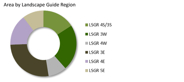
| LSGR 4S/3S |
5,858,195 |
1,258,317 |
255,701 |
7,372,212 |
4,169,015 |
| LSGR 3W |
8,602,094 |
1,673,449 |
194,060 |
10,469,603 |
7,045,575 |
| LSGR 4W |
2,818,090 |
643,931 |
709,124 |
4,171,145 |
2,098,345 |
| LSGR 3E |
10,385,386 |
960,938 |
1,140,000 |
12,486,324 |
8,536,281 |
| LSGR 4E |
4,660,078 |
963,910 |
1,422,719 |
7,046,707 |
3,730,369 |
| LSGR 5E |
2,079,217 |
444,650 |
2,284,822 |
4,808,689 |
1,516,834 |
| Total Area |
34,403,061 |
5,945,194 |
6,006,425 |
46,354,680 |
27,096,419 |
Total area by land class and landscape guide region (hectares)
| Land class |
3S/4S |
3W |
4W |
3E |
4E |
5E |
| Water |
1,583,827 |
1,715,678 |
671,012 |
827,103 |
806,361 |
496,113 |
| Wetland |
48,347 |
78,299 |
31,387 |
200,256 |
18,298 |
99,539 |
| Field/Agric. |
14,390 |
3 |
66,461 |
91,727 |
109,993 |
313,220 |
| Other |
144,669 |
62,709 |
40,707 |
76,251 |
230,548 |
160,699 |
| Treed Wetland |
228,782 |
410,272 |
146,064 |
781,472 |
122,061 |
135,300 |
| Forest |
5,352,574 |
8,202,642 |
3,215,515 |
10,509,515 |
5,759,446 |
3,603,817 |
| Total Area |
7,372,590 |
10,469,603 |
4,171,145 |
12,486,324 |
7,046,707 |
4,808,689 |
Map of landscape guide regions and forest management units
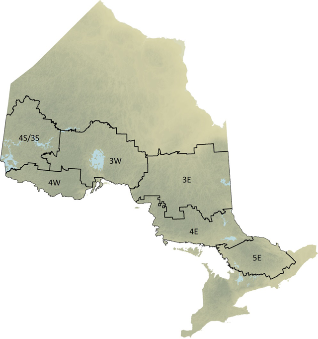
Enlarge map of landscape guide regions and forest management units
Area by landscape guide region
Total area by ownership and management unit–LSGR 3S/4S (hectares)
| Forest Management Unit |
Crown |
Parks and protected areas |
Other |
Total |
Crown Forest |
| Dryden Forest (535) |
202,320 |
9,388 |
93,963 |
305,671 |
117,549 |
| Kenora Forest (644) |
1,033,123 |
98,181 |
87,405 |
1,218,709 |
522,246 |
| Lac Seul Forest (702) |
1,042,911 |
21,554 |
36,351 |
1,100,816 |
741,632 |
| Red Lake Forest (840) |
249,492 |
45,572 |
19,116 |
314,180 |
179,216 |
| Trout Lake Forest (120) |
928,265 |
95,605 |
4,122 |
1,027,992 |
751,132 |
| Wabigoon Forest (130) |
677,248 |
47,774 |
3,798 |
728,820 |
527,902 |
| WhiskeyJack Forest (490) |
959,129 |
88,767 |
10,103 |
1,057,999 |
698,830 |
| Whitefeather Forest (994) |
764,637 |
406,538 |
842 |
1,172,018 |
630,507 |
| Other Non-FMU Area |
1,070 |
444,938 |
– |
446,008 |
– |
| Total Area |
5,858,195 |
1,258,317 |
255,701 |
7,372,212 |
4,169,015 |
Total area by ownership and management unit–LSGR 3W (hectares)
| Forest Management Unit |
Crown |
Parks and protected areas |
Other |
Total |
Crown Forest |
| Big Pic Forest (067) |
633,908 |
13,608 |
6,033 |
653,549 |
572,511 |
| Black Spruce Forest (035) |
1,192,479 |
138,063 |
31,342 |
1,361,884 |
1,017,880 |
| Caribou Forest (175) |
606,097 |
88,211 |
20,088 |
714,396 |
481,442 |
| English River Forest (230) |
1,026,409 |
99,991 |
60,106 |
1,186,507 |
787,973 |
| Kenogami Forest (350) |
1,852,199 |
63,622 |
50,459 |
1,966,281 |
1,601,795 |
| Lake Nipigon Forest (815) |
1,410,111 |
191,746 |
13,670 |
1,615,527 |
1,185,297 |
| Ogoki Forest (415) |
1,017,746 |
65,597 |
2,656 |
1,086,000 |
877,589 |
| Pic River Forest (965) |
460,305 |
27,365 |
5,718 |
493,388 |
521,087 |
| Other Non-FMU Area |
402,840 |
985,246 |
3,985 |
1,392,071 |
– |
| Total Area |
8,602,094 |
1,673,449 |
194,060 |
10,469,603 |
7,045,575 |
Total area by ownership and management unit–LSGR 4W (hectares)
| Forest Management Unit |
Crown |
Parks and protected areas |
Other |
Total |
Crown Forest |
| Crossroute Forest (405) |
1,269,964 |
54,901 |
259,776 |
1,584,641 |
875,528 |
| Dog-River Matawin Forest (177) |
900,621 |
21,661 |
136,977 |
1,059,259 |
712,266 |
| Lakehead Forest (796) |
383,062 |
63,849 |
310,691 |
757,602 |
313,022 |
| Sapawe Forest (853) |
264,443 |
33,716 |
1,680 |
299,839 |
197,529 |
| Other Non-FMU Area |
– |
469,803 |
– |
469,803 |
– |
| Total Area |
2,818,090 |
643,931 |
709,124 |
4,171,145 |
2,098,345 |
Total area by ownership and management unit–LSGR 3E (hectares)
| Forest Management Unit |
Crown |
Parks and protected areas |
Other |
Total |
Crown Forest |
| Abitibi River Forest (110) |
3,006,514 |
248,335 |
312,067 |
3,566,917 |
2,271,562 |
| Gordon Cosens Forest (438) |
1,720,682 |
150,121 |
123,102 |
1,993,905 |
1,503,471 |
| Hearst Forest (601) |
1,145,948 |
77,105 |
288,585 |
1,511,638 |
964,406 |
| Magpie Forest (565) |
387,234 |
1,983 |
48,541 |
437,758 |
320,594 |
| Martel Forest (509) |
993,629 |
139,093 |
51,673 |
1,184,394 |
859,154 |
| Nagagami Forest (390) |
440,912 |
3,127 |
1,470 |
445,509 |
377,268 |
| Pineland Forest (421) |
363,648 |
25,740 |
2,436 |
391,824 |
308,390 |
| Romeo Malette Forest (930) |
577,074 |
24,992 |
24,614 |
626,680 |
500,228 |
| Timiskaming Forest (280) |
1,171,970 |
72,960 |
286,315 |
1,531,244 |
952,967 |
| White River Forest (060) |
577,775 |
33,941 |
1,197 |
612,913 |
478,242 |
| Other Non-FMU Area |
– |
183,541 |
– |
183,541 |
– |
| Total Area |
10,385,386 |
960,938 |
1,140,000 |
12,486,324 |
8,536,281 |
Total area by ownership and management unit–LSGR 4E (hectares)
| Forest Management Unit |
Crown |
Parks and protected areas |
Other |
Total |
Crown Forest |
| Algoma Forest (615) |
805,224 |
147,203 |
612,618 |
1,565,045 |
708,661 |
| Nipissing Forest (754) |
753,563 |
84,213 |
305,119 |
1,142,895 |
550,136 |
| Northshore Forest (680) |
924,533 |
152,584 |
177,448 |
1,254,566 |
750,858 |
| Spanish Forest (210) |
1,090,056 |
133,491 |
5,910 |
1,229,458 |
922,263 |
| Sudbury Forest (889) |
657,151 |
153,198 |
271,023 |
1,081,373 |
460,905 |
| Temagami Forest (898) |
429,551 |
151,123 |
50,600 |
631,273 |
337,546 |
| Other Non-FMU Area |
– |
142,098 |
– |
142,098 |
– |
| Total Area |
4,660,078 |
963,910 |
1,422,719 |
7,046,707 |
3,730,369 |
Total area by ownership and management unit–LSGR 5E (hectares)
| Forest Management Unit |
Crown |
Parks and protected areas |
Other |
Total |
Crown Forest |
| Algonquin Forest (451) |
593,792 |
168,259 |
61 |
762,112 |
487,304 |
| Bancroft-Minden Forest (220) |
366,934 |
78,133 |
544,899 |
989,966 |
267,758 |
| French-Severn Forest (360) |
552,756 |
142,592 |
584,031 |
1,279,379 |
355,260 |
| Mazinaw-Lanark Forest (140) |
269,208 |
34,566 |
669,485 |
973,259 |
189,614 |
| Ottawa Valley Forest (780) |
296,527 |
21,100 |
486,345 |
803,972 |
216,898 |
| Other Non-FMU Area |
– |
– |
– |
– |
– |
| Total Area |
2,079,217 |
444,650 |
2,284,822 |
4,808,689 |
1,516,834 |