Alm Lake Forest Conservation Reserve Management Statement
This document provides policy direction for the protection, development and management of the Alm Lake Forest Conservation Reserve and its resources.
Statement of Conservation Interest
July 2004
Ministry of Natural Resources
Approval Statement
I am pleased to approve this Statement of Conservation Interest (SCI) for the Alm Lake Forest Conservation Reserve (C1534).
Direction for establishing, planning and managing conservation reserves is defined under the Public Lands Act and current policy. "Ontario’s network of natural heritage areas has been established to protect and conserve areas representative of the diversity of the natural regions of the province, including species, habitats, features and ecological systems which comprise that natural diversity" (Conservation Reserve Policy 3.03.05 OMNR 1997).
This basic SCI will provide guidance for the management of the conservation reserve and the basis for the ongoing monitoring of activities. More detailed direction at this time is not anticipated. Should significant facility development be considered or complex issues arise requiring additional studies, more defined management direction, such as a conservation reserve Resource Management Plan (RMP), may be developed.
This SCI was reviewed by staff specialists at both the district and regional level of the Ministry of Natural Resources. The public was consulted prior to the regulation of the Alm Lake Forest Conservation Reserve as well as prior to the approval of this SCI. Comments and concerns which were received are reflected in this Statement of Conservation Interest.
The Alm Lake Forest Conservation Reserve will be managed under the jurisdiction of the Area West Supervisor of the Ministry of Natural Resources, Chapleau District.
Submitted by:
Original signed by:
Rachel Foley
Plan Author
Dated: July 12th, 2004
Recommended for Approval by:
Original signed by:
Wayne Fiset
District Manager
Dated: July 12th, 2004
Approved by:
Original signed by:
Rob Galloway
Regional Director, Northeast Region
Dated: July 16th, 2004
1.0 Introduction
The Province of Ontario is home to a broad range of climate types, geography, and plant and animal species, all of which contribute to the variety and abundance of natural resources found here. The Ministry of Natural Resources (MNR) is the lead conservation and resource management agency in the province and is therefore responsible for the management of these resources, in particular, forests, fisheries, wildlife, mineral aggregates and petroleum resources, Crown lands and waters, and provincial parks and protected areas (MNR Beyond 2000).
The Ministry of Natural Resources is committed to the protection of natural and cultural heritage values and, as such, has developed strategies that will maintain the integrity and sustainability of the parks and protected areas system.
Recently, the Government of Ontario conducted a major land use planning exercise which resulted in the release of the Ontario’s Living Legacy Land Use Strategy (1999). The Land Use Strategy focuses on four specific objectives that were established to guide the planning process. These are:
- to complete Ontario’s system of parks and protected areas
- to recognize the land use needs of the resource–based tourism industry
- to provide forestry, mining, and other resource industries with greater land and resource use certainty
- to enhance hunting, angling and other Crown land recreation opportunities
Ontario’s network of natural heritage areas has been established to protect and conserve areas that represent the diversity of the natural regions of the province, including the species, habitats, special features and ecological systems which comprise that natural diversity. Protecting these natural heritage areas is essential to the sustainable management of natural resources. It ensures that representative sites are retained in their natural state and can continue to contribute to Ontario’s natural environment.
In order to preserve these sensitive areas they require protection from incompatible uses. The creation of conservation reserves has been identified as a way of providing necessary protection from incompatible uses while still permitting many of the traditional uses that allow the people of Ontario to enjoy our special heritage.
Conservation reserves complement provincial parks in protecting representative natural areas and special landscapes. Most recreational activities (e.g. hiking, skiing, tourism related uses and nature appreciation) that have traditionally been enjoyed in the area will continue, provided that these uses do not impact the natural features needing protection. The management and administration of a conservation reserve are guided by an approved Statement of Conservation Interest (SCI).
An approved Statement of Conservation Interest is the minimum level of management direction established for a conservation reserve. The Statement of Conservation Interest defines the area that is being planned and the purpose for which the conservation reserve has been established. In addition, it provides management direction that will protect its natural and cultural heritage values and demonstrate its compatibility within the larger landscape. In addition, to ensure MNR protection objectives are being fully met within the conservation reserve, the surrounding landscape and related activities must consider the site’s objectives and heritage values. Finally, it is the intent of this SCI to create a public awareness that will promote responsible stewardship of the protected area and surrounding lands.
The Alm Lake Forest Conservation Reserve is composed entirely of Crown lands and waters. Regulated in June 2003, this 752 hectare conservation reserve is located southwest of the Town of Chapleau and lies in the Territorial District of Sudbury, in Northeastern Ontario. The guidelines for the management of this conservation reserve are found in this document.
2.0 Goals and Objectives
2.1 Goal of the SCI
The goal of a conservation reserve as stated in Conservation Reserve Policy PL 3.03.05 (MNR, 1997) is to protect natural and cultural heritage values on public lands while permitting compatible land use activities. It is the intent of this Statement of Conservation Interest to provide the framework and direction to guide management decisions to ensure that the Alm Lake Forest Conservation Reserve will meet this goal through both short and long term objectives.
2.2 Objectives of the SCI
2.2.1 Short Term Objectives
In order to ensure that the goal of this conservation reserve is met, the following short–term objectives have been identified:
- Identify the state of the resource with respect to natural heritage values and current land use activities for the conservation reserve
- Manage the conservation reserve to protect the integrity of its natural values via specific guidelines, strategies and prescriptions detailed in this plan
This Statement of Conservation Interest meets the planning requirement for conservation reserves as determined in Conservation Reserve Procedure PL 3.03.05, which states that management plans must be written within three years of the regulation date. (OMNR, 1997)
2.2.2 Long Term Objectives
In addition to the short term objectives mentioned above, long term objectives will assist in ensuring that the goal of this conservation reserve is met. The long term objectives for this SCI are:
- To establish representative targets and validate the site as a potential scientific benchmark
- To identify research/client services and marketing strategies
- To provide direction to evaluate future uses or economic ventures
3.0 Management Planning
3.1 Planning Context
3.1.1 Planning Area
The planning area will consist of the regulated boundary for the Alm Lake Forest Conservation Reserve as defined in section 4.1.3 Administrative Description. This landbase will form the area directly influenced by this Statement of Conservation Interest. This plan will recognize the protection of values within the planning area, however, to fully protect values within the conservation reserve, additional consideration within larger land use or resource management plans may be required. Any strategies noted within this plan related to the site’s boundary or beyond will need to be presented for consideration within a larger planning context. The Ministry of Natural Resources in conjunction with other partners will work to ensure that the values are protected during planning and implementation of activities on the surrounding landbase.
3.1.2 Management Planning Context
The need to complete the parks and protected areas system has long been recognized as an important component of ecological sustainability. This was reaffirmed in 1997 when the Lands for Life planning process was announced. Previous gap analysis studies were used to determine proposed candidate areas that would protect additional representative features. The Alm Lake Forest Conservation Reserve was chosen as one of the candidate areas and subsequently appeared in the Ontario’s Living Legacy Land Use Strategy as C1534. Following consultations with the public, local aboriginal communities and affected industries, the boundary was finalized and approved by the Ministry of Natural Resources. The site was then formally regulated under the Public Lands Act.
By regulation under the Public Lands Act, conservation reserves cannot be used for mining, commercial forest harvest, hydro–electric power development, the extraction of aggregates and peat, or other industrial purposes. Most recreational and non–industrial resource uses that have traditionally been enjoyed will be permitted to continue provided that they pose no threat to the natural ecosystems and identified values of the conservation reserve.
Permitted uses in conservation reserves will generally follow the direction expressed in the Land Use Strategy as well as any prior commitments that have been made by the Ministry of Natural Resources, Chapleau District office. Future uses or developments that are proposed for this conservation reserve will be subjected to a Test of Compatibility (Appendix 9.2). Proposed uses and/or developments will also be subject to MNR's Resource Stewardship and Facility Development (RSFD) Class Environmental Assessment (EA), and may be subject to MNR's Class EA for Parks and Conservation Reserves, pending future approval. Considerations for proposals pertaining to cultural resources may be screened through direction provided in Conserving a Future For Our Past: Archaeology, Land Use Planning & Development In Ontario (Ministry of Citizenship, Culture and Recreation (MCzCr), 1997) as well as Policy 4.02.01 Cultural Heritage Screening, MNR–MCzCR Memorandum of Understanding, April 2001.
3.2 Planning Process
Management of the conservation reserve includes, as a minimum, the regulation, provision of public information, stewardship, and security of the site. It also includes authorization and setting conditions on permitted uses and ongoing monitoring of compliance with the approved management plan. Management of conservation reserves is the responsibility of the Ministry of Natural Resources at the district level, and will be done in accordance with Conservation Reserve Policy PL 3.03.05 and an approved management plan.
Once a conservation reserve has been established and regulated through the land use planning process, it will undergo a planning exercise to determine the future management of the site. The appropriate plan must be completed within three years of the regulation date.
There are two policy documents that may be prepared: a Statement of Conservation Interest or a Resource Management Plan.
A Statement of Conservation Interest is the minimum level of planning required for a conservation reserve and may take the form of either a Basic Stewardship SCI or an Enhanced SCI. A Basic Stewardship SCI is used for sites where no decisions beyond the Land Use Strategy are required. An Enhanced SCI is used for sites that have one or more issues that need to be addressed.
The highest level of planning for a conservation reserve is a Resource Management Plan and would be written if the conservation reserve were deemed to have numerous complex issues.
Based on the criteria, which can be found in Planning Process for Conservation Reserves: Statements of Conservation Interest and Resource Management Plans, Northeastern Region Guidelines (Shilf and Thompson, 2001), a Basic Stewardship Statement of Conservation Interest was determined to be the appropriate form of management plan for this conservation reserve. No issues have been identified in the Alm Lake Forest Conservation Reserve that would require decisions to be made beyond what has been previously determined in the Land Use Strategy.
Following the regulation of the Alm Lake Forest Conservation Reserve in June 2003, local First Nation communities and the public were notified that the management planning for the conservation reserve was underway. This notification occurred via mail–out to the First Nation communities and stakeholders and an advertisement appeared in two local newspapers during the week of March 1st, 2004. The Ministry of Natural Resources is exempt from providing notification of this planning process on the Environmental Bill of Rights Electronic Registry, under Section 30 of the Environmental Bill of Rights.
A draft version of this Statement of Conservation Interest was available for review by staff from the Ministry of Natural Resources as well as by members of the public and local First Nation communities. Comments provided to the ministry were considered in the preparation of the final document. Upon approval of this Statement of Conservation Interest, public notification will occur via mail–out to interested stakeholders and a notice will appear in the local newspapers.
This SCI is a working document and therefore may require revisions from time to time. For further information on reviews and revisions please see section 6.5 Implementation and Plan Review Strategies.
4.0 Background Information
4.1 Location and Site Description
4.1.1 Location
The Alm Lake Forest Conservation Reserve totals 752 hectares (ha) in size and is located approximately 50 km southwest of the Township of Chapleau, within the Chapleau MNR District in the Northeast Region.
Table 1 provides administrative details of the site:
Table 1: Location and Administrative Details for Alm Lake Forest Conservation Reserve
| Name | Alm Lake Forest Conservation Reserve |
|---|---|
| Site Region – Site District (Hills) | 4E–3 |
| Eco Region – Eco District (Crins and Uhlig, 2000) | 4E–3 Mississagi Ecodistrict with portions in Michipicoten Ecodistrict 4E–1 |
| MNR Administrative Region/District/Area | Northeast/Chapleau/Area West |
| Total Area | 752 ha |
| Regulation Date | June 7, 2003 |
| First Nations | Robinson–Superior Treaty (the local First Nation community affiliated with this treaty is Michipicoten First Nation) |
| OBM Map Sheets | 41 0/5 |
| UTM Reference | 291526 |
| Municipality | None |
| Township | Hancock, Fitzsimmons |
| Status | 100% Crown lands |
| Watershed | 2BE – Lake Superior Basin |
| Wildlife Management Unit | WMU 35 |
| Forest Unit | Superior Forest |
| Nearest Town | Chapleau |
4.1.2 Physical Description
This conservation reserve is found in the Mississagi Ecodistrict 4E–3 (Hills, 1959; Crins and Uhlig, 2000) and extends into the Michipicoten Ecodistrict 4E–1 (Crins and Uhlig, 2000). Both Ecodistricts are found within the Lake Temagami Ecogregion 4E. A general description of this area with respect to earth and life sciences can be found in Appendix 9.1.
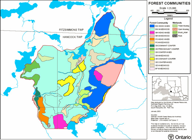
The Alm Lake Forest Conservation Reserve is almost entirely made up of white birch forest communities. Generally, the site is dominated by young white birch hardwood mixed and mixed wood forest communities with an age distribution of 30–59 years. Poplar hardwood mixed and poplar mixed wood each form stands in the southern portion of the site. Maple communities are associated with two large hills, one flanking the southern boundary and another along the eastern boundary of the site. These forest communities are generally older than the white birch communities and range between 60–89 years and 90–119 years of age. Black spruce communities are associated with lakes and wetlands along the western, southeastern and northern boundaries. Cedar dominated stands are found in the central part of the site and along the eastern boundary, while cedar mixed conifer stands are found in both the northern and southern parts of the conservation reserve. (Noordhof et al, 2003)
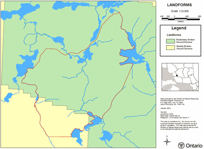
The central area of the Alm Lake Forest Conservation Reserve is underlain by undifferentiated, metasedimentary rocks of the Superior Province. The remaining northeast and southwest parts of the conservation reserve are underlain by foliated gneissic, granitic rock of the Superior Province.
The surficial geology is comprised primarily of an extensive bedrock–drift complex. Moderate bedrock exposure associated with a discontinuous cover of till is generally anticipated within these areas of bedrock–drift complex. Eskers are located along the northern boundary and the landform in western section of the site is predominately controlled by ground moraine. (Krisjansson, 2003)
The remaining area is occupied by lowland. Most of this area is underlain by till deposits, with the north and west lowland also containing ice–contact stratified drift deposits and glaciofluvial outwash deposits. Organic deposits also occur locally within all of the lowland environments.
This conservation reserve falls within the Lake Superior Basin, in the tertiary watershed 2BE. The Alm Lake Forest Conservation Reserve contains and borders a number of named and unnamed lakes and creeks. The major lakes found bordering the site include Pogey and Mutt Lake in the southeast, Lawless Lake in the west and Alm Lake in the northeast. The northern boundary is associated with an unnamed chain of lakes. Wetlands make up a small portion of this site and include a variety of wetland types including open low shrub bog, meadow marsh/thicket swamp, open water marsh, treed fen/bog, sedge/low shrub shore fen, tall shrub shore fen/meadow marsh and mixed marsh.
4.2 Administrative Description
The Alm Lake Forest Conservation Reserve was regulated as schedule 165 in Ontario Regulation 208/03 made under the Public Lands Act on May 14, 2003 and filed May 21,The legal description as found in the June 7th, 2003 edition of the Ontario Gazette, reads as follows:
In the geographic Townships of Fitzsimmons and Hancock, in the Territorial District of Sudbury, containing 752 hectares, more or less, being composed of that part of the said townships designated as Part 1 on a plan known as C1534 Alm Lake Forest Conservation Reserve, filed on February 14, 2003 with the Office of the Surveyor General of Ontario in the Ministry of Natural Resources.
4.3 History of the Site
There is little history with respect to this site. There has been a European presence in the area since the mid 1700's when competition in the fur trade became intense. In 18th century fur trade began decreasing as logging became the primary industry, with the first sawmills appearing in the early 1900's. The area, both including and surrounding the conservation reserve, may have been harvested during this period. First Nations of the region may have additionally utilized the lands of the Alm Lake Forest Conservation Reserve in the past. An archeological site check will be completed to establish if there are any registered archeological sites within this conservation reserve.
4.4 Inventories
The following table indicates what survey work has been done and what is required:
Table 2: Inventory and Survey Information
| Survey Level | Earth Science | Life Science | Cultural | Recreational |
|---|---|---|---|---|
| Reconnaissance Survey (RS) | Completed Sept. 25th, 2002 | Completed Sept. 25th, 2002 | None completed at this time | Completed Sept. 25th, 2002 |
| Detailed | Draft Earth Science Report completed February 2003 | Draft Life Science Report 2003 | None completed at this time | Recreational Report completed and approved, December 2003 |
| Requirement | Earth science interpretations should be digitized to assist with future landform vegetation analysis as time and funding permits. | Digitized life science information, SFU data, photos and sampling areas should be used to complete the current landform vegetation analysis as time and funding permits. | A registered archaeological site check will be completed during the summer of 2004. | Ground assessment of trails, roads and access points should be conducted as time and funding permits to further assess current uses and potential impacts to the site. Additionally, visits should be conducted in the winter to confirm seasonal use. |
5.0 State of the Resource
The natural heritage of Ontario contributes to the economic, social and environmental well being of the province and its people. Protecting areas of natural heritage is important for many reasons, such as maintaining ecosystem health and providing habitat for species in order to maintain diversity and genetic variability. Protected areas also provide scientific and educational benefits, recreational and tourism opportunities, which bolster local and regional economies, and they provide places where people can enjoy Ontario’s natural diversity while enhancing their own health and well–being. In order to protect this vital natural heritage, a protected areas system which represents the entire range of the province’s natural features and ecosystems is needed (Natures Best, 1997).
Representation:
Completing the system of parks and protected areas is based on the concept of representation – capturing the full range of natural and cultural values by protecting areas that contain the best examples of our history, natural features, species and ecosystems. The complete system must therefore protect a range of natural heritage values based on the geological, biological and cultural diversity of the province. The best examples of representative features are often considered to be provincially significant and may even be nationally or internationally significant. In addition, locally and regionally significant areas also contribute natural heritage values to the protected areas system and have therefore been identified in some areas to meet the representation targets in each of the site districts.
The primary value of this site is its provincially significant white cedar community found on weakly broken outwash plain sandy till which is not otherwise represented on this landform unit. (Noordhof et al, 2003)
This site additionally contains a diverse mixture of wetlands including meadow marshes and fen complexes, bogs, and marshes which help contribute locally to the system of protected areas.
Quality of Present Representation:
The quality of the representation or the current characteristics of the natural features found within the conservation reserve are as important as the overall representative features that are being protected. A number of factors are considered in evaluating a site and they include the following criteria: diversity, condition, ecological factors, special features and current land use activities.
a) Diversity
Diversity is evaluated in terms of the number and range (i.e. amount of richness and evenness) of vegetative communities currently present within the conservation reserve. Natural landscapes and known generalized vegetative communities will be the scale used for this SCI. Future aerial or ground reconnaissance surveys will enhance the MNR's knowledge of these features and possibly allow verification at a lower scale (e.g. species assemblages).
White birch communities, represented on ground moraine or bedrock controlled landscape, largely dominate the conservation reserve and therefore the overall diversity for the site is considered to be low. (Noordhof et al, 2003)
b) Ecological Factors
Ecological factors refer to the current design of the conservation reserve as noted by its size, shape, and buffering capacity to adjacent land use activities. Generally, larger sites with more diversity are better than small, non–diverse areas; sites with a more rounded or naturally delineated shape are better than long, linear sites; and sites that are linked to or near other protected areas are better than isolated protected areas. In addition, the site’s linkage to undisturbed landscapes also contributes to the conservation reserve’s ecological integrity.
The boundaries for this site are primarily derived from natural features. Though the northern boundary follows Hydro Line Road, Alm Lake makes up a portion of the eastern boundary of the site. In addition, the southeastern part of the site is bordered by Pogey and Mutt Lake. A significant portion of the western border consists of the edge of Lawless Lake and its associated creek systems. In all, there are only three vectored boundaries which are limited to a small section of the site.
Despite its small size of only 752 ha, the Alm Lake Forest Conservation Reserve has greater interior to edge ratio than linear shaped protected areas and is well connected to the broader landscape and forest communities beyond the boundaries of the site. The conservation reserve’s shape, natural boundaries, and linkages with broader, relatively isolated landscapes all contribute to its ecological integrity
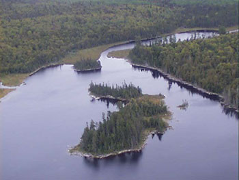
Figure 1: Alm Lake adjacent to the east border of site C1534.
c) Condition
Condition is the degree of past human and natural disturbances observed or recorded for the site. Major natural disturbances in the Northeast Region are caused by fire, wind damage, floods, or insect and disease infestation. Human disturbances are wide ranging and could include clear–cut areas, mining, railways, roads, trails, dams, cottages or other development.
The Alm Lake Forest Conservation Reserve is generally in good condition. The major disturbances to this site have been human induced. According to the aerial reconnaissance survey, there has been some gravel extraction along the road bordering the northern portion of the site. Numerous tertiary roads and trails have also been identified within the site, however, the values of the site have remained relatively undisturbed.
d) Special Features
Special features include interesting landscapes, habitats or vistas, Species at Risk (SAR) and other earth and life science features, including broader landscape elements that contribute to the natural heritage richness of Ontario.
The primary value of this site is its provincially significant white cedar community found on weakly broken outwash plain sandy till which is not otherwise represented on this landform unit. (Noordhof et al, 2003)
Other special features of this site include the two large hills on the south and southeast borders, which contain maple and white pine stands. It is also important to note that there are several small lakes that border the site. (Noordhof et al, 2003)
e) Current Land Use Activities
As previously mentioned, the quality of the representation or the current characteristics of the natural features found within the conservation reserve are as important as the overall representative features that are being protected. Land use activities can have a substantial impact on the quality of representation.
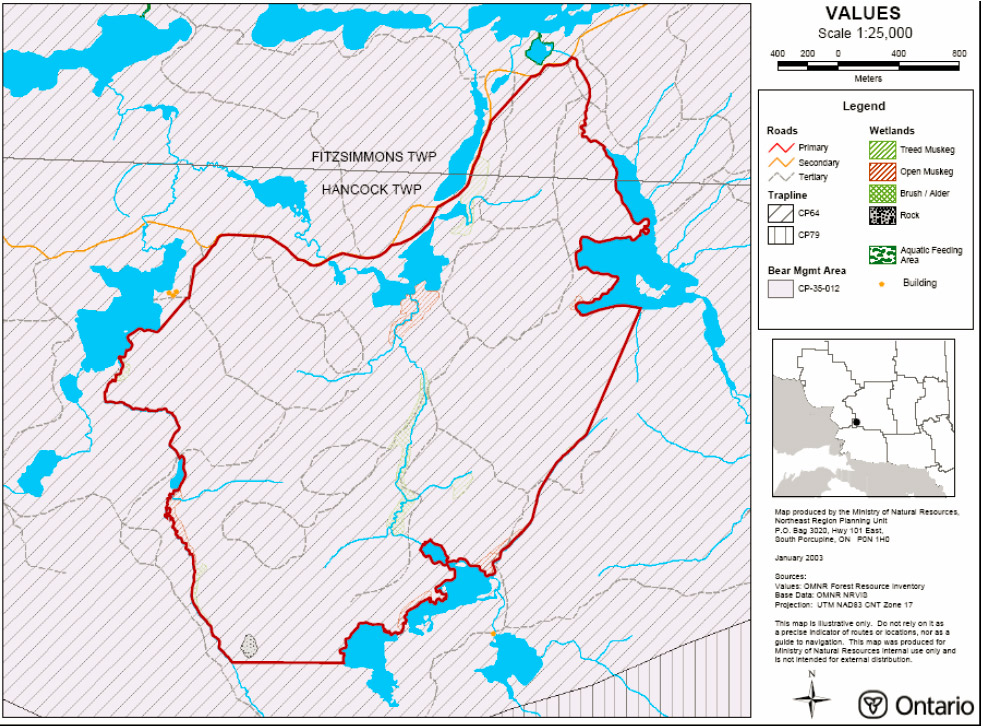
Currently, portions of one bear management area (BMA), one trapline and two commercial baitfish harvest areas (BHA) overlap the Alm Lake Forest Conservation Reserve. These activities will be permitted to continue within the conservation reserve. It is anticipated that there will be little change in the current use of the site and no meaningful impacts to the values of the site are anticipated.
5.1 Social Interest in Area
5.1.1 Linkage to Local Community
Alm Lake Forest Conservation Reserve is accessible by a secondary road, Hydro Line Road, which is situated along the northern boundary of the site. From this road numerous tertiary roads and trails can be accessed which lead into the conservation reserve.
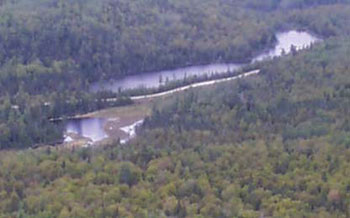
Figure 2: Hydro Line Road, along the northern border of the site.
This site provides the surrounding communities a protected area to enjoy outdoor activities which may include angling, hunting, nature appreciation, hiking, snow shoeing, ATV travel and snowmobiling.
5.1.2 Aboriginal Interests
The conservation reserve falls in the area of the Robinson–Superior Treaty. First Nations of the area may have utilized the lands of the Alm Lake Forest Conservation Reserve, however, no archaeological evidence has been found within the conservation reserve.
5.1.3 Other Government Agencies, Departments or Crown Corporations
Other agencies or departments that may have an interest in this conservation reserve include the Ministry of Tourism and Recreation, the Ministry of Culture, the Department of Fisheries and Oceans Canada, the Ministry of Northern Development and Mines, and the Ministry of Municipal Affairs and Housing. At this time, no other government agency has shown a specific interest with respect to this particular protected area.
5.1.4 Non Government Organizations and other Industry Interest
Industrial sectors that may have an interest in the Alm Lake Forest Conservation Reserve could include the forestry industry, the mining industry and the tourism industry. Non–government organizations that may have an interest in the site, could include the Partnership for Public Lands, the Federation of Ontario Naturalists, Northwatch, the Chapleau Regional Development Corporation, the Baitfish Association of Ontario, the Northern Ontario Tourist Outfitters as well as local snowmobile clubs, trapper councils, and hunting and angling organizations.
Both the Partnership for Public Lands and the Ontario Federation of Anglers and Hunters expressed a desire to review the draft version of this SCI.
5.2 Natural Heritage Stewardship
The Alm Lake Forest Conservation Reserve contributes to the province’s parks and protected areas system. Through formal protection under the Public Lands Act and long–term management direction, the site’s natural heritage values and representative features will be protected.
By allocating these lands to the parks and protected areas system, the province has ensured a certain level of permanence by distinguishing the site and its values from the surrounding landscape. Each protected area contributes to Ontario’s natural heritage in its own unique way – whether it is a contribution to the preservation of an earth science value, a life science value, a recreational or economic opportunity or cultural and historical values.
The site’s earth and life science features, as described in section 4.1.2, make a number of contributions to the province’s natural heritage values. Specifically, this site contributes life science representation through its provincially significant landform vegetation complex of white cedar on weakly broken deep outwash plain sandy till.
This site is accessible for scientists and educators who wish to study values of the site while continuing to be available for recreationalists who wish to enjoy the opportunities that the site has to offer.
5.3 Fisheries and Wildlife
The wildlife found within the site is consistent with typical wildlife found in Ecodistrict 4E–3, including the various types of birds and ungulates. District trapping files also confirm the presence of numerous furbearing animals, including beaver, muskrat, marten, lynx, and fox. Black bears and wolves have also been found within the area.
Though a preliminary lake survey was conducted for the adjacent Lawless Lake, no detailed fisheries data has been collected for within the conservation reserve.
Aerial surveys for moose and for osprey, eagle and heron nests are completed on a district scale on a regular basis. To date, however, no detailed wildlife studies have taken place within the conservation reserve and so the importance of the site to wildlife species, particularly Species at Risk, and their habitats, has yet to be determined.
5.4 Cultural Heritage Stewardship
There are no known cultural heritage values within the Alm Lake Forest Conservation Reserve and to date no detailed research has been conducted to document any possible cultural heritage values.
A registered archaeological site check will be completed during the summer of 2004. If any registered sites are found to be within the site, special protection measures may be developed to protect the cultural values and further cultural heritage analysis may be carried out.
5.5 Existing Development and Land Use
This conservation reserve is on Crown Land and does not contain any land use permits (LUPs), patents, licenses of occupation, leases, mining tenure or any other form of land tenure.
At present, there are no existing structures within the conservation reserve. A secondary road forms the northern boundary of the site from which access to the site can be gained by numerous tertiary roads and trails. These roads and trails are the only infrastructure currently existing within the site.
5.6 Commercial and Industrial Use
This conservation reserve falls within one trapline area (CP 64) with the nearest trap cabin lying outside the conservation reserve. In addition, portions of one Bear Management Area (CP 35–012) and two commercial Baitfish Harvest Areas (CH0143, CH0158) are also present within the site.
This conservation reserve has no mining tenure within it. Mining and surface rights have been withdrawn from staking within the conservation reserve boundaries under the Mining Act (RSO 1990 Chapter M.14). This area is also protected from any future timber harvesting, as outlined in provincial conservation reserve policy.
5.7 Recreational Use
Current recreational uses include angling, hunting, nature appreciation, hiking, ATV use, and snowmobiling. There are currently no proposals for new recreational uses or tourism facilities within this site.
5.8 Client Services
Visitor services will primarily involve responding to inquiries about basic information such as natural heritage representation and appreciation, permitted uses, access and boundaries. In addition to the provision of public information regarding the protected area, concerns with respect to public safety and area security will be addressed.
6.0 Management
6.1 Management Planning Strategies
Earth and life science features will be protected from adverse impacts by defining permitted uses, enforcing regulations (Ont. Reg. 805/94 PLA), monitoring site use and mitigating any identified concerns. The land use intent outlined in the Land Use Strategy provides context and direction to land use and resource management within this conservation reserve. Commitments identified in current policy (PL 3.03.05 and Ontario’s Living Legacy Land Use Strategy) will form the basis for the management planning strategies presented within this SCI. For up to date information on permitted uses refer to the Crown Land Use Policy Atlas. (/page/crown–land–use–policy–atlas)
New land use activities and development proposals will be reviewed on a case by case basis. However, a Test of Compatibility (Appendix 9.2) must be passed before any uses or developments are deemed acceptable. The emphasis will be on ensuring that the natural values of the conservation reserve are not negatively affected by current or future activities.
The development of this SCI and the long term management and protection of the Alm Lake Forest Conservation Reserve will be under the direction of the MNR's Chapleau District, Area West Supervisor.
6.2 State of the Resource Management Strategies
The following sections outline some of the management strategies that have been developed to maintain and protect the identified values of the site. A detailed list of permitted uses within this conservation reserve can be found in Appendix 9.3 of this SCI. Additional information can be found in the Land Use Strategy as well as on the Ministry of Natural Resource Crown Land Use Policy Atlas.
6.2.1 Aboriginal Interests
Traditional activities and Aboriginal rights, as defined by the Robinson–Superior Treaty, will not be affected within the boundaries of this conservation reserve. All Aboriginal and treaty rights will continue to be recognized and will not be impacted by the designation of the area as a provincial conservation reserve.
6.2.2 Natural Heritage Stewardship
The management intent of this conservation reserve will be to protect natural ecosystems, processes and features while continuing to allow compatible, land use activities.
The MNR recognizes fire as an essential process fundamental to the ecological integrity of conservation reserves. In accordance with existing Conservation Reserve Policy and the Forest Fire Management Strategy for Ontario, forest fire protection will be carried out as on surrounding lands. Whenever feasible, the MNR fire program will endeavor to use "light on the land" techniques, which do not unduly disturb the landscape, in this conservation reserve.
Examples of light on the land techniques may include limiting the use of heavy equipment or limiting the number of trees felled during fire response efforts. Opportunities for prescribed burning to achieve ecological or resource management objectives may be considered. These management objectives will be developed with public consultation prior to any prescribed burning, and will be reflected in an amendment to this SCI document. Plans for any prescribed burning will be developed in accordance with the MNR Prescribed Burn Planning Manual, and the Class Environmental Assessment (EA) for Provincial Parks and Conservation Reserves (approval pending). In the interim, the Ministry of the Environment’s Exemption Order 59/2 will apply.
MNR will provide leadership and direction for maintaining the integrity of this site as a natural heritage estate. Research, protection, education and understanding and interpretation of the natural heritage features of the site will be encouraged and fostered through local and regional natural heritage programs and initiatives.
The introduction of exotic and/or invasive species will not be permitted. Programs may be developed to control forest insects and diseases in the conservation reserve where these threaten significant heritage, aesthetic, or economic values. Where control is desirable and possible, it will be directed as narrowly as possible to the specific insect or disease. Biological control will be used wherever possible.
In addition, the collection/removal of vegetation and parts thereof will not be permitted. However, subject to a Test of Compatibility, the Area Supervisor may authorize the collection of plants and/or parts of plants for the purposes of rehabilitating degraded sites within the reserve if required and for research or scientific study.
Exceptions based on a Test of Compatibility may also be made for minor structures for monitoring and research for scientific purposes (see section 6.4).
6.2.3 Fish and Wildlife
Fish and wildlife resources will continue to be managed in accordance with applicable policies and regulations prevailing in the area and under the direction of the Area West Supervisor.
Existing trapping, hunting and sport fishing activities will be permitted to continue unless there are significant demonstrated conflicts. (OMNR, 1999)
6.2.4 Cultural Heritage
As previously stated, no cultural resources have been identified in the Alm Lake Forest Conservation Reserve. If archaeological or cultural resources are discovered within the conservation reserve, proposals pertaining to the development or use of these cultural resources will be subject to MNR's Class EA for Resource Stewardship and Facility Development Projects or the Provincial Parks and Conservation Reserve Class EA, pending approval. This may lead to screening through direction provided in Conserving a Future For Our Past: Archaeology, Land Use Planning & Development In Ontario (Ministry of Citizenship, Culture and Recreation, 1997) as well as Policy 4.02.01 Cultural Heritage Screening, MNR–MCzCR MOU, April 2001.
6.2.5 Existing Development and Land Use
The tertiary road/trail network is the only form of existing infrastructure within the site. This development and any existing resource access roads can continue to be used but new resource access roads will not be permitted
The sale of lands within this conservation reserve is not permitted as per direction outlined in the Land Use Strategy. Road realignment, energy transmission, communication and transportation corridors, resource roads, or construction of facilities are discouraged. It is recognized that in some circumstances there may be no viable alternatives in which case options to minimize potential impacts to the values of the site will be determined through applicable planning processes. (OMNR, 2000)
Any future development proposals will be reviewed on a case by case basis, subject to all conservation reserve policies and a Test of Compatibility.
6.2.6 Commercial and Industrial Use
The current level of commercial hunting and trapping will be permitted to continue. New trapping operations may be considered subject to a Test of Compatibility
Existing commercial bear management operations are permitted to continue. The issuance of new licenses for existing commercial bear hunting operations will be permitted where areas have been licensed or authorized for the activity at any time since January 1, 1992, provided that the activity does not create or aggravate resource sustainability issues. New licenses will not be permitted in areas where a license for commercial bear management has not been issued since January 1, 1992. (OMNR, 2003)
New applications for commercial tourism outpost camps, main base lodges or associated facilities may be considered in the context of this management document and may be subject to a Test of Compatibility.
Industrial activities such as timber harvesting, mining, and new hydro generation will not be permitted within the boundaries of the conservation reserve as per Conservation Reserve Policy 3.03.05. As mentioned above, the existing authorized access roads will be permitted to continue however no new resource access roads will be permitted.
6.2.7 Recreation
Recreation activities that have traditionally been enjoyed in this area are permitted to continue provided they do not significantly impact the values of the site. (OMNR, 1999) Current recreational activities include angling, hiking, hunting, ATV use and snowmobiling.
Access into the conservation reserve by snowmobile and ATV will continue to be permitted on existing trails. Use of motorized vehicles off trail is not permitted except for the sole purpose of retrieving game.
Currently, no recreational or interpretive facilities exist within the conservation reserve. Future recreational development or new recreation facilities will be considered subject to a Test of Compatibility.
No new private recreation camps will be permitted in the conservation reserve.
6.2.8 Client Services
Under the direction of the Area West Supervisor, Chapleau District, staff will respond to requests for information on the site pertaining to regulated boundaries, natural heritage values, current access and infrastructure, permitted uses or any other additional information that is required.
A general fact sheet regarding the values of this site will be prepared and made available to the public at the Chapleau District Office.
6.3 Specific Feature/Area/Zone
The eastern white cedar community found on weakly broken outwash plain sandy till is one of the principal reasons this site was designated as a protected area. All attempts will be made to disturb this community as little as possible. In the event that a portion of the community has to be disturbed to allow for inventory, research, or any other proposed activity, a Test of Compatibility will be completed to determine if such an activity is acceptable.
In the future, if the representative features of the site are threatened by increased use, it may be necessary to regulate access or permitted uses in certain areas. In such a case, special management areas may be developed. These areas would facilitate permitted/restricted activities for the protection of specific values. The creation of these areas would require additional planning beyond this SCI including public consultation and eventual plan amendment if approved.
6.4 Promote Monitoring and Research
Scientific research by qualified individuals, which contributes to the knowledge of natural and cultural heritage and to environmental and recreational management, will be encouraged. Research related to the study of natural processes will also be encouraged provided it does not harm the identified values of the conservation reserve.
This site should be considered as a potential monitoring and/or research site. The relatively easy access and undisturbed forest communities of the conservation reserve could provide both MNR and associated partners potential sampling or monitoring areas. All research programs will require the approval of the Ministry of Natural Resources and will be subject to ministry policy and other legislation. Those interested in pursuing research within the conservation reserve must apply to the Area West Supervisor for approval. Applications to complete the research will follow guidelines as outlined in Procedural Guidelines C – Research Activities in Conservation Reserves (Conservation Reserve Procedure PL 3.03.05) or equivalent direction formulated by the MNR Chapleau District Office. Approvals will meet all terms and conditions established by the MNR Chapleau District Office.
The ministry may approve, on a case by case basis, the removal of any natural or cultural specimen by a qualified researcher. All such materials removed remain the property of the Ministry of Natural Resources.
Additional life and earth science requirements, as previously outlined in section 4.4, will refine the values of this site and assist with further development of management guidelines. As time and funding permits, the completion of more detailed life and earth science inventories will further help define the role of this conservation reserve within the system of provincially protected areas.
6.5 Implementation and Plan Review Strategies
Implementation of this SCI will primarily involve monitoring activities to ensure adherence to the management guidelines. Other activities will include funding future life and earth science inventories, preparing a fact sheet highlighting the important natural heritage values of the conservation reserve and responding to inquiries about the site.
Implementation of the SCI and management of the conservation reserve are the responsibility of the Area West Supervisor. Partnerships may be pursued to address management needs. The Alm Lake Forest Conservation Reserve SCI will be reviewed on an ongoing basis. If changes in management direction are needed at any time, the significance of the changes will be evaluated. Minor changes, which do not alter the overall protection objectives, may be considered and approved by the Area Supervisor without further public consultation and the plan will be amended accordingly.
In assessing major changes, the need for a more detailed Resource Management Plan (RMP) will be considered or, where a management plan is not considered necessary or feasible, a major amendment may be considered. Both options will involve public and First Nation consultation. Notification may additionally occur on the Environmental Bill of Rights Registry. The MNR Regional Director will approve any major amendments
This SCI and the Crown Land Use Policy Atlas will be amended, as required, to reflect any changes in management direction.
6.6 Marketing Strategies
The Alm Lake Forest Conservation Reserve will be promoted as a distinctive natural area having significant life science values. As mentioned above, a fact sheet will be prepared to inform the public about the values of this site however, at this time, marketing efforts to increase use are not a priority and will be kept to a minimum.
7.0 References
Bostock, H.S. 1970. Physiographic subdivisions of Canada; in Geology and Economic
Minerals of Canada, Geological Survey of Canada, Economic Geology Report no. 1:11–30.
Chapman, L.J. and M.K. Thomas. 1968. The Climate of Northern Ontario. Canadian Department of Transport, Meteorological Branch, Toronto. Climatological Studies Number 6. 58pp.
Crins, W.J. 1996. Life Science Gap Analysis for Site District 4E–3. OMNR.
Crins, W.J. and Peter W.C. Uhlig. 2000. Ecoregions of Ontario: Modifications to Angus Hills' Site Regions and Districts. Revisions and Rationale. 7pp and map.
Hills, G.A. 1959. A ready reference to the description of the land of Ontario and its productivity: Division of Research Ontario Department of Lands and Forests. Maple, Ont. A–4.
Krisjansson, F.J. 2003 Draft Earth Science Inventory Checklist for Alm Lake Forest (C1548), OMNR
Noordhof, J., Thompson, J.E., King, L., Longyear, S. 2003. Draft Alm Lake Forest Forest Conservation Reserve (C1548) Life Science Inventory Checklist –Step 2; OMNR
MacLeod, J. 2002. Recreation Inventory Report for Alm Lake Forest Conservation Reserve. Ontario Ministry of Natural Resources. Chapleau District.
Ontario. Ministry of Natural Resources. 1983. Chapleau District Land Use Guidelines.
Ontario. Ministry of Natural Resources. 1993. Ontario’s Natural Heritage. Endangered Spaces Candidate Area Report.
Ontario. Ministry of Natural Resources 1997. Conservation Reserve Policy and Procedure PL3.03.05. OMNR. 30pp.
Ontario Ministry of Natural Resources (MNR). 1997. Nature’s Best: Ontario’s Parks and Protected Areas, A Framework and Action Plan. Lands and Natural Heritage Branch, The Natural Heritage Section, Peterborough, Ontario.
Ontario Ministry of Natural Resources. 1999. Ontario’s Living Legacy Land Use Strategy. Queen’s Print for Ontario.
Ontario Ministry of Natural Resources. September 2000. Policy Clarification for Conservation Reserves.
Ontario Ministry of Natural Resources. 2002. Alm Lake Conservation Reserve (C1534) Fact Sheet.
Ontario Ministry of Natural Resource, June 25, 2003. Memo: Direction for Commercial Use Activities in Provincial Parks and Conservation Reserves.
Ontario Ministry of Natural Resources, 2004. Crown Land Use Policy Atlas (/page/crown–land–use–policy–atlas).
Poser, Scott. 1992. Report on the Status of Provincial Parks in the Site Regions and Districts of Ontario – Draft Report.
Rowe, J.S. 1972. Forest Regions of Canada. 20 pp.
Schilf, Johanna and John E. Thompson. 2001. Planning Process for Conservation Reserves: Statements of Conservation Interest and Resource Management Plans, Northeastern Region Guidelines. OMNR.
8.0 Maps
Map 8.1: Alm Lake Forest Conservation Reserve Location Map
Map 8.2: Alm Lake Forest Conservation Reserve Values Map
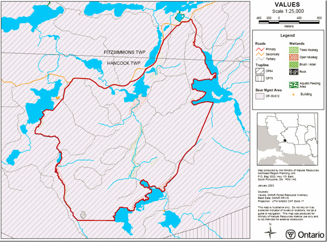
Enlarge Map 8.2: Alm Lake Forest Conservation Reserve Values Map
Map 8.3: Alm Lake Forest Conservation Reserve Life Science Map
Enlarge Map 8.3: Alm Lake Forest Conservation Reserve Life Science Map
Map 8.4: Alm Lake Forest Conservation Earth Science Map
Enlarge Map 8.4: Alm Lake Forest Conservation Earth Science Map
9.0 Appendicies
Appendix 9.1: General Description of the Region
Climate
Chapleau District is situated entirely within the Height–of–Land climatic region of Northern Ontario (Chapman and Thomas, 1968). The climate can be classified as continental, but is somewhat modified by elevation, and particularly in the southwestern part of the District, by the influence of Lake Superior. Most of the District’s precipitation comes in the summer and fall. The frost–free period for the town of Chapleau extends from mid June to early September, while temperatures range from a January mean of 15.6° C to a July mean of 16.7° C.
Characteristics of the Ecoregion and Ecodistrict
The Alm Lake Forest Conservation Reserve is located in the northwest corner of the Mississagi Ecodistrict and extends into the Michipicoten Ecodistrict. Both of these sites are found in the Lake Temagami Ecoregion (4E). This region is generally described as having hill slopes and basins occupied by well–drained glacial deposits, with peatlands restricted to local wet plains and depressions. Level, very rolling clay deposits are prevalent on the Paleozoic plain. The Mississagi Ecoregion is found to contain a gently rolling plain of stony sandy till over bedrock with frequent flat ridges of water–laid sand. The Michipicoten Ecoregion is composed of gently sloping upland areas that are deeply incised by narrow steep–walled valleys.
Forest Region
The Alm Lake Forest Conservation Reserve is found within the Missinabi–Cabonga Section of Rowe’s (1972) Boreal Forest Region. The Missinabi–Cabonga Section contains mixed forests of balsam fir, black spruce and white birch with scattered white spruce and trembling aspen. The presence of eastern red and white pine can be found on rocky shores and ridges, but only to a small degree due to past logging operations. Jack pine is situated along rivers and found in association with black spruce on poor rocky soils. Black spruce is also found in association with tamarack and white cedar in wet lowland areas.
Appendix 9.2: SCI Test of Compatibility
The screening process and associated criteria identified in Table 4.1 of the draft Class EA give planning staff more direction than the Conservation Reserve (CR) policy 3.03.05. However, this section attempts to assist planning staff by providing some direction for further interpreting the criteria to complete a Test of Compatibility for uses within a CR.
This section is taken From the SCI Test of Compatibility NER Guidelines in Planning process for Conservation Reserves Statement of Conservation Interest (SCI) and Resources Management Plans (RMP) Northeast Region Guidelines Version 2.1 September 17, 2001 Appendix 4, page 44.
Test of Compatibility
- Conformity to SCI – This is not applicable to evaluating current or new uses that come forward during the SCI planning process. However, the SCI should include a statement that speaks to the required screening of any future use or uses that are not covered in the current SCI.
-
Screening Process – proposed uses for the area must be assessed before they are approved. To establish a minimum standard, NER recommended that the Screening Process identified in Section 4.2 of A Class EA for Provincial Parks and Conservation Reserves Phase IIB: Draft Class EA (subject to approval by MOE) be used to screen projects and options.
The Screening Criteria from the draft Class EA (Table 4.1) is further detailed below within the context of SCI planning.
-
Impact Assessment –The Test of Compatibility from the Conservation Reserve (CR) Policy PL 3.03.05 identifies the classes of values and main concepts that need to be considered in determining the impacts of uses on a specific CR.
These include:
- Natural Heritage
- Cultural
- Research activities
- Current uses
- Area administration
- Accommodating the use outside the CR
- Socio–economics
- Area accessibility
The Class EA (Table 4.1) presents similar values and concepts under the following considerations:
- Natural environment
- Land use, resource management
- Social, cultural and economic
- Aboriginal
The above considerations and classes of values are meant to assist planning staff in answering the following questions for any potential use:
- Will the new use impact any values within the CR?
- If so, how?
- To what degree?
- Is it tolerable?
The following information for each CR is available and can be used to asses the required criteria:
- Background information and current inventory data
- Current inventory evaluations (e.g. earth, life and recreational check–sheets)
- Future ongoing analysis on the site
Interpretation of Background Information and Current Inventory Data
Background information files, summaries and other data can also help identify criteria that should be considered in MNR's applicable EA screening process. Criteria that are linked to habitat needs for specific life or earth science features are often first recorded during a District’s initial review of a site. Databases such as NRVIS or documents such as Lake Survey files, Site District Reports or Forest Management Plans can identify the location of values and sometimes determine a value’s significance or sensitivities.
Current Inventory Evaluations
The most current 'state of the resource' for a specific conservation reserve will be the earth, life and recreational check–sheets. These documents determine the current earth and life science values, their present state and their significance. The recreational check–sheets determine recreational features and current and potential recreational activities and feature significance and sensitivity to present and future uses.
For earth and life science check–sheets, five (5) major sections are completed that include; representation and the quality of the representation (e.g. based on condition, diversity and ecological considerations) and special features. There are five categories that are reflected within the screening criteria presented in the draft Class EA document or could be used to develop additional criteria. The five categories are listed below:
- Representation
- Condition
- Diversity
- Ecological Considerations
- Special Features
Future Ongoing Analysis on the Site
If during planning specific information is not available to complete impact assessment, this will be documented and the information will need to be acquired before further management decisions are made. In addition, future inventory, monitoring, assessment and research within the Conservation Reserve may also help planners and managers deal with future uses and impact assessments.
Appendix 9.3: Summary of Permitted Uses
Commercial Uses
| Issue and Activity | Permitted | Explanation |
|---|---|---|
| Commercial fishing – new | Maybe | New operations can be considered subject to a test of compatibility |
| Commercial fishing – existing | Yes | Existing uses permitted to continue unless there are significant demonstrated conflicts |
| Commercial fishing – transfer | Maybe | Transfers will be considered within the context of the SCI, subject to a test of compatibility |
| Bait–fish harvesting – new | Maybe | New operations can be considered subject to a test of compatibility |
| Bait–fish harvesting – existing | Yes | Existing uses permitted to continue unless there are significant demonstrated conflicts |
| Bait–fish harvesting – transfer | Maybe | Requests for transfer will be dealt with on an on–going basis and can be considered subject to a test of compatibility |
| Commercial bear hunting – New | No | New operations will not be permitted. New operations are defined as an activity that has not licensed or authorized since January 1, 1992. |
| Commercial bear hunting – existing | Yes | Existing operations will be permitted to continue indefinitely. Existing operations are defined as an activity that has been has been licensed or authorized at any time between January 1, 1992 and June 25, 2003. |
| Commercial bear hunting – transfer | Maybe | Requests for transfer will be dealt with on an on–going basis and not deferred until the completion of a SCI or RMP |
| Commercial fur trapping – New | Maybe | New operations may be considered subject to test of compatibility, including consideration for the associated trails that may be required |
| Commercial fur trapping – existing | Yes | Existing uses permitted to continue unless there are significant demonstrated conflicts |
| Commercial fur trapping – transfer | Yes | Requests for transfer will be dealt with on an on–going basis and can be considered subject to a test of compatibility |
| Trapping cabins – New | No | Not permitted |
| Trapping cabins – Existing | Yes | Existing use are permitted to continue, including repair and replacement, as long as the scale and function are not significantly altered. Relocation may be permitted if consisted with protection of natural heritage values. |
| Trapping cabins – transfer | Yes | Trapping cabins are included in the transfer of a commercial fur trapping licence |
| Outpost camps/tourism facilities – New | Maybe | New tourism facilities can be considered during planning |
| Outpost camps/tourism facilities – Existing | Yes | Existing authorized tourism facilities can continue unless there are significant demonstrated conflicts. Tourism facilities can apply to upgrade tenure from LUP to lease. Applications will be subject to a test of compatibility. |
| Outpost camps/tourism facilities – transfer | Maybe | Requests for transfer will be dealt with on an on–going basis and can be considered subject to a test of compatibility. |
| Wild rice harvesting – existing | Yes | Existing uses permitted to continue unless there are significant demonstrated conflicts |
| Wild rice harvesting – transfer | Maybe | Request for transfer will be dealt with on an on–going basis and can be considered subject to a test of compatibility |
| Food harvesting – new | Maybe | New operations can be considered subject to a test of compatibility |
| Food harvesting – existing | Yes | Existing uses permitted to continue |
| Food harvesting – transfer | Maybe | Request for transfer will be dealt with on an on–going basis and can be considered subject to a test of compatibility |
Industrial Activities
| Issue and Activity | Permitted | Explanation |
|---|---|---|
| Energy transmission corridors and communication corridors – existing | Yes | Permitted to continue |
| Energy transmission corridors and communication corridors – new | No | New corridors should be discouraged through planning however it is recognized that in some circumstances there will be no alternatives. |
| Commercial hydro power generation | No | Not permitted |
| Commercial timber harvest | No | Not permitted |
| Cutting of trees by leaseholders, cottagers, for fuel wood and other small–scale uses | No | The cutting of trees for non–commercial purposed is not permitted. Exceptions may be authorized by permit, subject to a review and determination of the impact that such cutting would have on natural heritage values. This flexibility is intend only for leaseholders, cottagers and other property owners who do not have road access to their property. |
| Timber salvage | Maybe | If provided for in an SCI or RMP, standing, fallen or sunken trees may be removed for resource management purposed. Such trees may be marketed if economical |
| Forest renewal in recently harvested areas | Yes | Renewal can be conducted where it will be of net benefit to the protected area. Review and approval of the proposals must be completed by appropriate silvicultural and program staff responsible for the management of the protected area in order to determine what actions would best support he long–term ecological integrity of the area. |
| Extraction of peat, soil, and aggregate | No | Not permitted |
| Mining and Mineral Exploration | No | No new exploration on untenured land is permitted. All existing mining land tenure within the conservation reserve including mining claims, leases, licenses of occupation and patents, will remain protected under the Mining Act and will be treated as any other in the Province |
| Roads – existing | Yes | Existing authorized roads can continue to be used. With regards to resource access roads, where alternative access does not exist or road relocation is not feasible, road will continue to be available for access. Continued use includes maintenance and may include upgrading. |
| Roads – new | Maybe | New roads for resources extraction will not be permitted except for those identified in Forest Management Plans before March 31, 1999 and for which no viable alternative exists. |
| Private access roads – existing | Yes | The maintenance of existing roads will be permitted, however upgrading will not be permitted |
| Private access roads – new | No | Where there is no prior commitment, new private access roads will not be permitted. Where MNR made a commitment prior to March 29, 1999, to permit a private access road within a recommended protected area, the road proposal will be subject to completion of a public planning process. |
Recreational Activities
| Issue and Activity | Permitted | Explanation |
|---|---|---|
| Sport fishing | Yes | Existing and new uses permitted to continue |
| Sport Hunting | Yes | Existing and new uses permitted to continue |
| Motorized boating | Yes | Existing and new uses permitted to continue |
| Canoeing/Kayaking | Yes | Existing and new uses permitted to continue |
| Non–trail ATV use | No | Non–trail ATV use may be permitted for direct retrieval of game only |
| Recreation Trail – existing (motorized and non–motorized) | Yes | Existing authorized trails can continue unless there significant demonstrated conflicts |
| Recreation Trail – new (motorized and non–motorized) | Maybe | New trails can be considered subject to a test of compatibility |
| Private recreation camps – new | No | Not permitted |
| Private recreation camps – existing | Yes | Existing authorized recreation camps permitted to continue and may be eligible for enhanced tenure but not for purchase of land (enhanced tenure being defined as anything beyond the term and form of current tenure). Enhanced tenure is not guaranteed and will be addressed through a screening process, such as a test of compatibility. |
| Private recreation camps – transfer | Maybe | Requests for the transfer of a recreation camp may be considered subject to a test of compatibility |
Science, Education and Nature Appreciation
| Issue and Activity | Permitted | Explanation |
|---|---|---|
| Research | Yes | Any proposed research activity must be approved by the Area Supervisor. |
| General Walking | Yes | Existing and new uses permitted to continue |
| Photography and Painting | Yes | Existing and new uses permitted to continue |
| Wildlife Viewing | Yes | Existing and new uses permitted to continue |
| Outdoor Education/ Interpretation | Yes | Existing and new uses permitted to continue |
| Collecting | No | Collecting may only be permitted as part of an authorized research project. The issuance of permits will be considered on a per–site basis. |
Other
| Issue and Activity | Permitted | Explanation |
|---|---|---|
| Land Disposition – sale | No | exception (road allowances, installation of septic system, etc.) where it does not detrimentally affect the values an area is intended to protect |