Callander Bay Wetland Conservation Reserve Management Statement
This document provides policy direction for the protection, development and management of the Callander Bay Wetland Conservation Reserve and its resources.
Statement of Conservation Interest
Ontario Ministry of Natural Resources and Forestry
North Bay District
2004
Approval statement
We are pleased to approve this Statement of Conservation Interest (SCI) for the Callander Bay Wetland Conservation Reserve (C149).
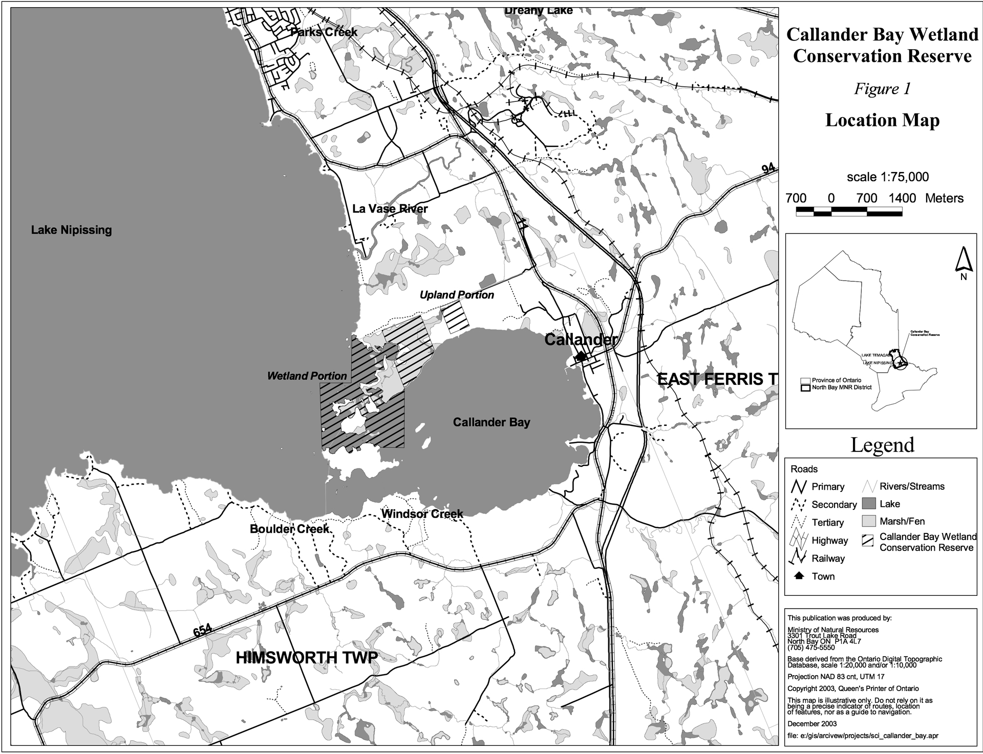
Callander Bay Wetland Conservation Reserve is located in Ecodistrict 5E-5 approximately 4 km west of the town of Callander. The Conservation Reserve (CR) encompasses 319 hectares of Crown land on the southeast side of Lake Nipissing. Included within the CR is the center channel and the northwest portion of Callander Bay. The area exhibits a highly diverse wetland environment with the presence of fen, swamp and marsh habitat. This Provincially Significant Wetland (PSW) provides an important waterfowl staging and breeding ground as well as optimal spawning and nursery conditions for Lake Nipissing’s fish population.
Callander Bay Wetland CR is one of 378 new protected areas approved through Ontario’s Living Legacy, a land use strategy aimed, in part, at completing Ontario’s system of parks and protected areas.
During the Lands for Life planning process the public was widely consulted and provided valuable input into what became Ontario’s Living Legacy. Comments received during that time, and during consultation related to the formal regulation of the boundaries of this CR were generally supportive of the protection of this area.
Stakeholders who expressed an interest in the planning of this site were notified regarding the draft SCI and given a one month review period. Any comments, including input from previous consultation, were considered in the finalization of this document. There was limited interest expressed by the public during the review of the draft SCI. No new issues have been identified. This SCI was also reviewed by MNRF staff.
This SCI provides guidance for the management of the CR and the basis of the ongoing monitoring of activities. More detailed direction is not anticipated at this time. Should significant facility development be considered or complex issues arise requiring additional studies, more defined management direction or special protection measures, a more detailed Resource Management Plan will be prepared with full public consultation.
Callander Bay Wetland CR is managed under the direction of the District Manager and the Resource Operations Supervisor, North Bay District, Ministry of Natural Resources and Forestry.
Prepared by:
Klara Vodicka
OLL Planning Intern
Date: December 15, 2003
Original signed by:
Dave Payne
District Manager
North Bay District
Date: December 19, 2003
Rob Galloway
Regional Director
Northeast Region
Date: January 9, 2004
Administrative update approved by:
Mitch Baldwin
North Bay District Manager
Date: July 21, 2017
Corrinne Nelson
Northeast Regional Director
Date: July 24, 2017
1.0 Introduction
The purpose of this Statement of Conservation Interest (SCI) is to identify and describe the values of the Callander Bay Wetland Conservation Reserve (CR). The SCI also outlines the activities that occur within the CR and provides guidelines for the management of current and future activities in the context of protecting the natural, social and cultural values of the CR. A SCI is prepared under the authority of Procedural Guideline A – Resource Management Planning (PL. Procedure 3.03.05).
Callander Bay Wetland CR is located on the southeastern shore of Lake Nipissing approximately 12 km south of North Bay near the town of Callander. The boundary of the CR is located in the geographic townships of Himsworth and Ferris within the municipalities of North Himsworth and the City of North Bay respectively (Figure 1). The CR includes the central portion of the channel leading into Callander Bay and the northwestern region of the bay. Adjacent shoreline, the lakebed and Crown islands are included within the CR. A large variety of vegetative communities exist within the CR boundaries, thus making the area rich in biodiversity.
Conservation reserves are established by regulation under the Provincial Parks and Conservation Reserves Act (PPCRA). Callander Bay Wetland Conservation Reserve was originally established by Ontario Regulation 208/03, under authority of the Public Lands Act (O. Reg. 805/94) on June 7, 2003, but has since been regulated under O. Reg. 315/07 of the PPCRA (2006). The planning area for this SCI is the regulated boundary of the CR.
1.1 Planning context
Ontario’s Living Legacy Land Use Strategy was approved in 1999. The objectives of the Land Use Strategy are to complete Ontario’s system of protected areas; recognize the land use needs of resource-based tourism industry; provide forestry, mining and resource industries with greater certainty around land and resource use; and enhance hunting, angling and other Crown land recreational opportunities. Callander Bay Wetland CR was created as part of the expansion of protected areas.
Conservation reserves protect natural heritage values on public lands, while permitting compatible land use activities. By allocating these lands to the parks and protected areas system through regulation, the province has ensured a certain level of permanence by distinguishing the CR and its values from the larger general use or more extensively managed landscape. In addition, the CR's natural features are, and will be available for present and future generations to enjoy and explore.
Ontario’s Living Legacy Land Use Strategy (1999) outlines the general land use policy and management direction for new Conservation Reserves. Each new CR will have a planning document, either a SCI or, in more complex situations, a Resource Management Plan, that details site-specific management direction.
Comments received during the Lands for Life process, and during consultation related to the formal regulation of the boundaries of this site were generally supportive of the establishment of this area as a CR. Stakeholders who expressed an interest in the planning were notified regarding the draft SCI and given a one month review period where the draft was made available. Any comments, including input from previous consultation, were considered in the finalization of this document. There was limited interest expressed by the public during the review of the draft SCI. This SCI was also reviewed by MNRF staff. Although more detailed direction is not anticipated at this time, should significant facility development be considered or complex issues arise requiring additional studies, more defined management direction or special protection measures, a more detailed Resource Management Plan will be prepared with full public consultation.
1.2 Background information
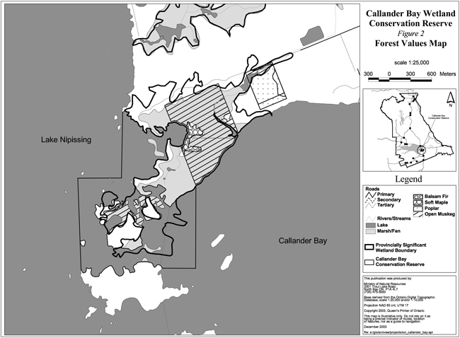
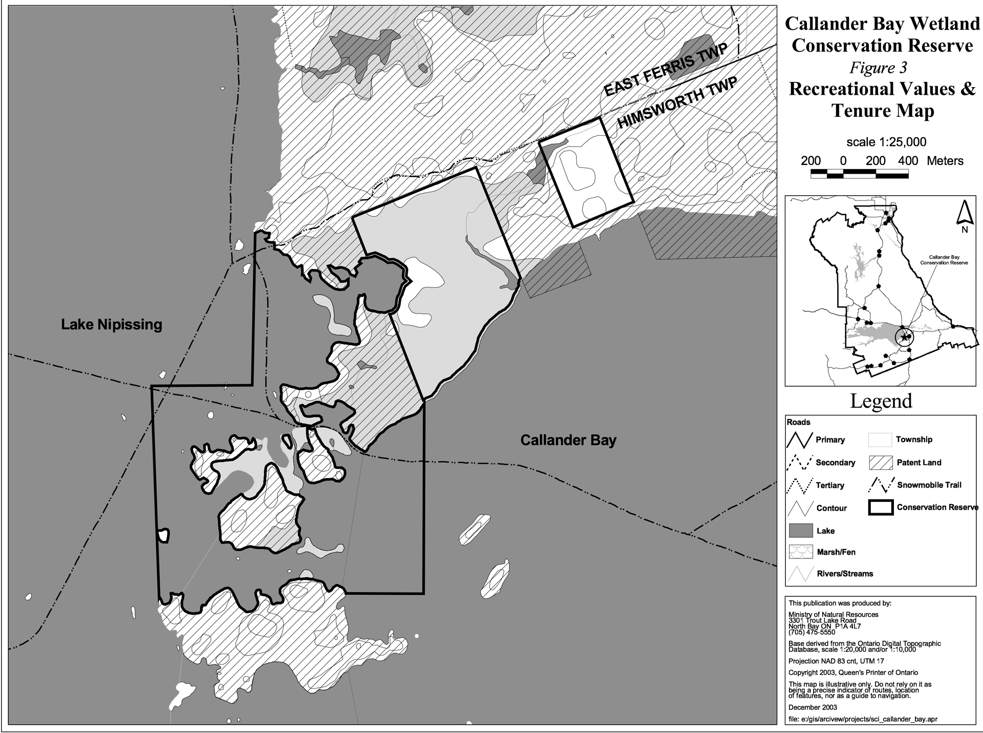
Callander Bay Wetland CR encompasses part of the northern shoreline of Callander Bay as well as Crown portions of the central channel leading into the bay. The central area includes parts of Grand Trunk Island and a significant portion of the surrounding lakebed. Smith Island borders the CR to the south (Figure 1). Patent land and the water of Lake Nipissing surround the CR (Figure 3). The site encompasses a Provincially Significant Wetland (PSW) (Figure 2) which provides crucial habitat for a variety of wildlife. The CR contains important fish spawning and waterfowl habitat. The site provides many recreational opportunities including sport fishing, hunting and berry picking. The CR can be accessed in the winter using Ontario Federation of Snowmobile Clubs (OFSC) trails that cross through the central and western portion of the site. As well, indirect access can be achieved by Cranberry Road, a tertiary road, that runs just north of the CR (Figure 3). From this tertiary road a network of unmaintained walking trails provide some access to the site.
The following chart summarizes administrative information for Callander Bay Wetland CR:
Table 1 - Administrative information CR149
| Name and OLL ID Number | Callander Bay Wetland Conservation Reserve (C149) |
|---|---|
| Ecoregion/Ecodistrict (Hills, 1959; Crins, 2000) | 5E (Georgian Bay), 5E-5 (North Bay) |
| MNRF Administrative Region/District/Area | Northeast Region/North Bay District |
| Total Area (ha) | 319 |
| Regulation Date |
Original regulated on June 7, 2003 (O. Reg. 805/94) under the Public Lands Act Since regulated under O. Reg. 317/07 of the Provincial Parks and Conservation Reserves Act (2006) |
| Township(s) | Himsworth, Ferris |
| First Nations | Nipissing First Nation – area of interest – through the Robinson Huron Treaty Mattawa North Bay Algonquins – area of interest Antoine First Nation – area of interest |
| OBM map sheets | 2017 6200 51100 – 2017 6200 51200 |
| Topographic Map Name/Number | Powassan 31 L/3 |
| UTM coordinates | 621,700 m E 5,118,700 m N |
| General Location, Description, Access | Approximately 12 km south of North Bay and 4 km west of Callander on the southeastern shore of Lake Nipissing. Site contains mixed wetland habitat including fen, swamp and marsh. Winter access is available by OFSC trails that run through the central channel and western portion of the Conservation Reserve. Access is also available by boat in the summer or indirectly by a tertiary road that runs north of the site. |
1.3 Goals
The goals of this SCI are:
- To provide background information.
- To identify and describe the values of the CR.
- To provide guidelines for the management of current and future activities while protecting natural, social and cultural heritage values.
1.4 Objectives
The following objectives are identified as a means to achieve the above-stated goals.
- To describe the state of the resource with respect to natural heritage values and current land use activities.
- To manage the CR to protect the integrity of its natural values via specific guidelines, strategies and prescriptions.
- To meet planning requirements by addressing the management intent of the CR and addressing planning and management needs.
- To create a public awareness of the values within the CR and promote responsible stewardship of the protected area through partnerships with local stakeholders.
- To determine long-term management goals of the CR by identifying research, client services and marketing strategies.
- To identify scientific values on the site in relation to provincial benchmarks and identify the necessary monitoring and/or research to maintain the integrity of those values.
- To provide direction to evaluate new uses or economic ventures through the application of the PPCRA (Statues of Ontario, 2006), the Class Environmental Assessment for Provincial Parks and Conservation Reserves (MNRF 2005), and the Protected Area Compatibility Test (Appendix 1). This review process will evaluate the impact of proposed use(s), either positive or negative, on the protected values of the CR.
- To work with the municipality to protect private land portions of the wetland and adjacent lands.
1.5 Representation
The following subsections provide a summary of the life science, earth science and cultural heritage values, as well as recreational opportunities.
Life science representation:
This CR, which encompasses a Provincially Significant Wetland, contains 65 vegetation communities lying on lacustrine organic soils of clay/loam texture with a fibric origin (Meil et al., 1993). The upland portions of the CR contain mixed coniferous and deciduous vegetation on sandy loam, coarse sand and outwash materials (North Bay-Mattawa Conservation Authority, 1998).
The following landform types and vegetation associations are found (Burkhardt et al., 2003):
- Highly diverse lacustrine area composed mainly of marsh, swamp and fen vegetation with some upland areas
- Wetland consists of open muskeg with some mixed hardwoods, such as red maple
- Dominant vegetation forms in wetland areas include narrow-leaved emergent, robust emergents, tall shrubs, deciduous trees, low shrubs and submerged plants
- Less dominant vegetation forms in wetland areas include broad-leaved emergents and herbs
- Upland vegetation consist of mixed deciduous and mixed coniferous vegetation
- Eastern upland portions of the conservation contain balsam fir/poplar mixedwoods, with some poplar hardwood and balsam fir mixed conifer stands
- Areas surrounding the creek and pond in the upland portion of the Conservation Reserve contain open muskeg
- High use Cranberry Bog dominated by peatland and the large cranberry
- Many transitional zones present within the Conservation Reserve and between Crown and patent land
- Topography flat/rolling hills
- Hydrologically connected to other wetland types, channels and open water
- Part of Lake Nipissing Watershed
- Catchment soil coverage thin and permeability high Seasonal and semipermanent flooding in wetland areas Moderate pH
- Fish habitat present in low marsh and high marsh areas that are seasonally and permanently flooded
- Important spawning and nursery habitat for Lake Nipissing’s sport fish populations
- Important waterfowl staging and breeding ground
- Species of provincial, regional and special significance present
Earth science representation:
The bedrock is composed of migmatitic and granitic gneisses from the Grenville Province of the Canadian Sheild. Glaciolacustrine and organic clay/loam textured soils make up the wetland portions of the CR while upland portions contain coarse sand or gravelly sand outwash materials. Bedrock knob or knoll forms with intervening somewhat lower elevation areas are characteristic (Kristjansson, 2003).
Cultural heritage values:
Callander Bay Wetland CR was identified as having high potential heritage areas within the site. The site also contains a historical point of interest. The CR is in the area of interest for Nipissing First Nation, the Mattawa North Bay Algonquins and the Antoine First Nation. More in-depth research concerning cultural heritage values has not been completed to date.
Recreational opportunities:
The site offers a variety of recreational opportunities including; sport fishing, hunting, boating, bird watching, hiking on informal trails, wildlife viewing, berry picking, cross country skiing, snowmobiling and canoeing. Possible trail system development at the northern portion of the CR may provide additional access to the site (Tremblay, 2002).
1.6 Survey work
The following table provides an overview of inventories completed, their level of detail, and any further inventories that are required. A detailed amount of survey work has been carried within the boundaries of the CR. The MNRF conducted a wetland evaluation of the site in 1993 and the North Bay-Mattawa Conservation Authority completed an inventory report for the area in 1998.
Table 2 - Survey work summary
| Survey level | Life Science | Earth Science | Cultural | Recreational |
|---|---|---|---|---|
| Reconnaissance | Burkhardt, B., 2003, Life Science Checksheet Aerial Survey Noble, 1991, Life Science Checksheet for Callander Bay Cranberry Bog |
Kristjansson, F.J., 2003, Earth Science Checksheet, Aerial Survey (in progress) | First Nations Interviews, 1998 & 2003, Native Background Information Report and Values Maps, related to Forest Management Planning | Tremblay, D., 2002, Recreational Inventory Checklist, Aerial and Ground Survey |
| Detailed | Meil et al., 1993, Wetland Evaluation, Ground survey North Bay-Mattawa Conservation Authority, 1998, Callander Bay Wetland Complex and Surrounding Upland Area Inventory Report | None | None | None |
| Requirement | None | None | None | Monitor on on-going basis |
2.0 State of the Resource
The CR is located entirely within Ecodistrict 5E-5 (Crins, 2000). Values include life science, earth science, cultural and recreational/aesthetic with an emphasis on the life science and recreational values.
Significance is determined on the basis of the following criteria: representation, diversity, condition, ecological considerations and special features (Crins and Kor, 1998).
-
Representation: Callander Bay Wetland CR is comprised of wetland vegetation with a section of upland vegetation at the northeastern portion of the site (Figure 2).
There are eight vegetation forms and 65 communities within the marsh, swamp and fen portions of the CR. The dominant forms include narrow-leaved emergents, robust emergents, tall shrubs, deciduous trees, low shrubs and submerged plants (Photo 2). Narrow-leaved emergents and robust emergents are found in all areas of the wetland. The former includes such species as reed canary grass, burreed, wild rice and various other grasses and sedges while the latter includes cattails and bulrushes. Tall and low shrubs are found throughout the fen and swamp portions of the wetland. They include winterberry, various willow species, sweet gale, leatherleaf, and the large cranberry. Deciduous trees such as red maple, silver maple and black ash are found only in swamp portions of the wetland while submerged plants such as pondweed and American eel-grass are found within marsh areas. There are also less dominant forms present within the CR, they include broad-leaved emergents and herbs. Broad-leaved emergents such as pickerel-weed, arrowheads and water plantains are found in marsh and swamp areas. Herbs such as the marsh St.Johns-wort and the sensitive fern are found in all areas of the site. Mosses are present as well, however they are found only in fen and swamp areas (Meil et al., 1993).
The upland portion of the CR is comprised of mixed deciduous and mixed coniferous vegetation. The mixed deciduous forest includes poplar, red maple, trembling aspen, largetooth aspen, and white birch mixed with some coniferous species such as eastern white cedar. Other mixed coniferous forest includes balsam fir, white pine, hemlock, red pine and white spruce (North Bay-Mattawa Conservation Authority, 1998).
-
Diversity: Diversity is a measure of the CR' earth and life science variety. The evaluation is based on the number and range (assortment) of landscape features and landforms for earth science values and the relative richness and evenness of the site’s life science components.
Callander Bay Wetland CR contains a high level of vegetative diversity considering the small size of the 319 hectare site. The wetland portion of the CR was found to contain 67 different species by the North-Bay Mattawa Conservation Authority (1998) and 65 different vegetative communities by the MNRF (1993). The upland areas within and around the CR were found to contain 15 tree species, 23 shrub species and 47 understory species (North Bay-Mattawa Conservation Authority, 1998). There is not only a high amount of diversity within the site but also surrounding the site. The site is surrounded by abandoned agricultural fields, pasture, fence rows, abandoned pits and/or quarries, deciduous forest, mixed forest, coniferous forest, rock outcrop, creek floodplain, open lake or deep river. Thus, there is a great amount of interspersion or edge effect within and at the boundaries of the CR. This edge effect enhances the biodiversity within the CR by creating various transitional areas between different habitat types. Many species depend on a variety of habitat types for survival.
This diverse community setting results in a high level of associated wildlife diversity. The Wetland Evaluation for Callander Bay (1993) revealed the presence of a variety of mammals such as moose, beaver, and mink. The Callander Bay Wetland Complex and Surrounding Upland Area Inventory Report (1998) uncovered a variety of herpetofaunal species. The site is a regionally significant waterfowl staging, moulting and breeding ground as well as a migratory passerine, shorebird and raptor stopover area (Meil et al. 1993; North Bay-Mattawa Conservation Authority 1998). Thus, a considerable amount of bird diversity exists within the CR. The proximity of this wetland to Lake Nipissing and the incorporation of part of the large channel located at the northwestern part of Callander Bay into the CR boundaries allows for ideal spawning and nursery habitat to be included within the site (North Bay-Mattawa Conservation Authority 1998). Callander Bay is very important to the health, and thus diversity, of Lake Nipissing’s fish population. All of these combined factors make this site extremely rich and biodiverse.
-
Condition: Overall the CR, including a Provincially Significant Wetland, is in fairly good condition with respect to its natural features. Human disturbance has occurred in and around this area for many years. Logging activities were known to have occurred in the areas near and potentially within the CR. The J.B Smith Saw Mill, established in 1888, functioned until 1950, located east of the CR. Past timber harvesting has left little trace of its presence except for the existence of an old logging road. This road, which runs through the center of the CR, is currently being used by the OFSC as a club trail. Portions of other OFSC trails are present near the western part of the site. Natural disturbances, such as beaver activity and the invasion of purple loosestrife have been observed within the associated wetland communities. As well, the proximity of a golf course and sewage lagoon could potentially disturb the site in the future. Chemical runoff from the golf course and the input of waste/water into the bay could have detrimental effects on the integrity of the life science values associated with the CR. However, presently, there is a general overall lack of disturbance in the area. Recreational uses within the CR include angling, hunting, berry picking, boating, snowmobiling, cross-country skiing, bird watching, hiking, general nature activities and canoeing. A variety of authorized commercial land-uses for such activities as baitfishing and trapping also occur in and around the area. However, these activities are believed to have little impact on the core ecological values of the site.
- Ecological considerations: Callander Bay Wetland CR is a small 319 hectare area comprised of a portion of Crown shoreline, Crown islands, a channel and lakebed portions of Lake Nipissing (Figure 1). The design of Callander Bay Wetland CR has utilized the boundaries of surrounding patent lands in its organization. Approximately two thirds of the wetland is under Crown ownership while the rest is privately owned. The boundaries of the CR were drawn to exclude patent lands leading to a divided site. The CR is completely bordered by private lands or by the waters of Lake Nipissing. Pressure could be inflicted on this site, depending on the type of land use activities occurring in adjacent areas. A tertiary road, which provides an access point, lies only a few hundred meters from the northern boundary. This road leads to an unmaintained informal network of walking trails, which provides limited access to the site (Photo 4). This could place additional pressure on the CR by user groups, however the area is mainly used for low impact hunting and trapping purposes. The MNRF will strive to develop partnerships with local stakeholders, landowners and the municipality in order to ensure that life science values are protected.
-
Special features: There are a variety of unique life science features associated with Callander Bay Wetland CR. The distinctive habitat created by a combination of 65 communities within three types of wetland makes this site highly diverse. One particular community, known as the Callander Bay Cranberry Bog, provides many recreational opportunities for cranberry picking in the fall. The vegetative diversity within the site provides opportunities for a variety of wildlife as well.
The CR is a regionally significant waterfowl staging, moulting and breeding ground as well as a migratory passerine, shorebird and raptor stopover area. The site provides feeding habitat for various provincially and regionally significant species such as caspian tern, least bittern, short eared owl, marsh wren an orange-crowned warbler. The bald eagle has also been spotted flying above the CR (Tafel, 2003). The osprey can also be found within the CR. The CR not only supports various bird species but mammals, amphibians and various fish species as well.
The site is home to various furbearing mammals such as muskrat, beaver, mink, martin and otter. There is some ungulate summer cover and aquatic feeding areas for moose as well. The blue-spotted salamander, an indicator species of ecosystem health, was reported within or near the site (North Bay-Mattawa Conservation Authority, 1998).
Callander Bay Wetland CR also serves as an important spawning and nursery habitat for Lake Nipissing’s fish population. This crucial habitat helps to replenish Lake Nipissing’s pike, walleye and muskellunge populations and thus, support recreational fishing opportunities in the area.
2.1 Life Science
Gap analysis is a method of identifying gaps in representation of all landform/vegetation features within the Ecodistrict, and to identify potential sites that best fill those gaps. The objective of gap analysis is to complete representation of all vegetation community and landform types within protected areas (Bergsma, 1995). During the Lands for Life planning exercise, the emphasis for new protected areas was sites identified through gap analysis. Callander Bay Wetland CR was not identified through gap analysis, but was put forward as a CR on life science representation for site region 5E (Noble, 1991).
Callander Bay Wetland CR provides a unique yet highly representative sample of wetland diversity. The lacustrine wetland includes marsh, swamp and fen habitats, a known Cranberry Bog with a small portion that is dedicated to upland habitat. The presence of 65 vegetative communities helps to provide a diverse habitat for a variety of wildlife. The CR provides important waterfowl staging and breeding grounds as well as a habitat for various provincially and regionally significant bird species. The site includes a channel and parts of the lakebed which contain important spawning and nursery habitat for Lake Nipissing’s fish population. The area is considered to be in fairly good condition despite the past recreational and commercial use.
2.2 Earth Science
Callander Bay Wetland CR is part of the Grenville Province of the Canadian Shield. The area is generally composed of the metamorphosed bedrock with igneous intrusions and folds. The alkaline Precambrian geological complex within Callander Bay Wetland CR is composed of migmatitic and granitic gneisses as well as gneissic rocks of metasedimentary origin of mesoproterozoic age. Callander Bay was formed by carbonated nephelinitic magma originating in the mantel which, helped to form a nepheline syenite ring in the northern mainland portion of the CR (North Bay-Mattawa Conservation Authority, 1998).
The CR has marsh/swamp basin topography of flat and rolling hills with seasonal and semipermanent flooding. There is a small upslope catchment area, thin catchment soil coverage, high catchment soil permeability and moderate pH. These factors are present due to the physical topography and soil types present within the region. A large amount of glacial activity has occurred in this area in the past. The geology of the site has been strongly influenced by continental glaciation and post-glacial drainage. The lower wetland portions of the Conservation Reserve include glaciolacustrine and organic deposits. Lacustrine soils that are exposed to the lake make up 74% of the wetland, Lacustrine soils exposed at the rivermouth make up 2%, while 24% of the soils are palustrine. Organic soils occupy 10-50% of the wetland with mineral or undesignated soils. Three quarters of the soils have a clay/loam texture and one quarter are of fibric origin (Meil et al., 1993). The northern section of the CR appears to be underlain by areas of bedrock-drift complex glaciolacustrine deposits and organic deposits. Bedrock knob or knoll forms with intervening somewhat lower elevation areas are characteristic.
The majority of the soils in the wetland portions of the CR consist of unclassified depression marsh with very poor drainage that are periodically flooded or continuously wet. The central channel portion of the CR, which contains various Crown islands, is comprised primarily of rockland, thin soils underlain by Precambrian bedrock with variable slopes and drainage regimes. These areas are considered to be exceeding stony and rocky. Approximately one third of this same area consists of sandy loam orthic humo-ferric podzol with very stony and rocky areas. This noncalcareous very stony sand or sandy loam glacial till of Precambrian origin has good drainage on a moderately to strongly rolling slope (OMAF, 1986).
Approximately two thirds of the soils in the upland portion of the CR consist primarily of sandy loam gleyed humo-ferric podzol. This noncalcareous sand, coarse sand or gravelly sand outwash materials has poor drainage on a nearly level slope which is free of stones. The other third is comprised of rockland, thin soils underlain by Precambrian bedrock with variable slope and drainage regimes and exceedingly stony and rocky areas (OMAF, 1986).
2.3 Cultural values
There are high potential cultural heritage areas within the CR that were identified using a computer based predictive modeling program. Based on a series of pre-defined parameters, the program identifies candidate areas, which are most likely to be culturally significant. As well, the CR contains traditional hunting, trapping and fishing grounds that have been identified by the Nipissing First Nation, the Mattawa North Bay Algonquins and the Antoine First Nation (First Nations Interviews, 1998 & 2003). There are no archeological sites identified within the boundaries of the CR however there are two sites in close proximity. The La Vase Park Site is considered to a "farmstead site with a prehistoric component." The Bowels Island site near the first site has yielded chert flakes. There is one historical point of interest, known as the Smith Island Shipwrecks, within the boundaries of the Conservation Reserve (North Bay-Mattawa Conservation Authority, 1998).
2.4 Recreational/Aesthetic values
The CR offers a wide array of recreational activities in close proximity to the village of Callander and the city of North Bay, two population centers. Recreational opportunities can be accessed by boat, canoe or by a tertiary road which, stretches from Cranberry Road northeast of the site (Figure 3). This road, a winter time snowmobile trail, allows for some access into the CR through a network of informal, unmaintained paths that extend into the site (Photo 4). In the future individuals may be admitted to the site using a proposed trail system that will run through the northern portion of the wetland. This trail may be connected to the Trans-Canada Trail that runs east of the site, potentially creating more recreational opportunities for local residents and tourists (Township of North Himsworth, 1999).
Sport fishing, hunting and cranberry picking are just a few of the many other recreational activities that take place in Callander Bay Wetland CR. Anglers find a great diversity of fish species in the bay and are thus continually attracted to the site both in the summer and winter months. A wide variety of duck species provides outstanding hunting prospects. Other recreational opportunities will likely remain unchanged such as cranberry picking which, occurs mostly in the fen portions of the CR. Berry picking is a popular fall activity. Boating and canoeing offer some summer recreational activities while snowmobiling and cross-country skiing become popular winter activities. OFSC trails run through the center and western portion of the CR which links Lake Nipissing to the village of Callander and to numerous land based trails (Figure 3). The site offers excellent birdwatching opportunities because of the presence of nesting heron colonies (Photo 3) and the recent reintroduction of trumpeter swans to the area. Various provincially and regionally significant species feed, migrate and nest at the site. Hiking and other general nature appreciation activities can be accomplished year round. A model airplane club located in close proximity to the CR, on township property, may also use portions of the CR for recreational flying. The current activities are believed to have a limited impact on the integrity of the site and thus will be permitted to continue.
2.5 Heritage estate contributions
Callander Bay Wetland CR evaluated, as Provincially Significant Wetland, has been set aside because of the distinctive nature of the site. There are many unique life science features associated with the site. There is a wide array of vegetative diversity present within the boundaries of the CR. This provides a rich environment so that a variety of wildlife may inhabit the site.
There are three different wetland types with 65 different communities included within the CR. This range of communities along with the many transitional zones between them produces optimal conditions for a wide variety of species, some which are of regional, provincial and special significance. Thus, the area provides excellent educational opportunities.
The CR is located in close proximity to two populated areas, the City of North Bay and the recently expanding, Town of Callander. Thus, a great deal of recreational use of the site presently exists. The uses include sport fishing, hunting, berry picking, boating, bird watching, hiking, wildlife viewing, and general nature appreciation activities. Snowmobiling and cross country skiing are recreational activities that take place in the winter months.
The protection provided through designation, as a CR, will help to ensure the preservation of the site for future generations. Callander Bay Wetland CR will provide many of the same recreational opportunities to future generations that currently exist there today. Partnerships with adjacent landowners and recreational users will be fostered in order to encourage the protection of life science, cultural and recreational values in and around the site.
3.0 Management guidelines
3.1 Management planning strategies
The land use intent outlined in Ontario’s Living Legacy Land Use Strategy provides context and direction to land use, resource management, and operational planning activities on Crown land. Commitments identified in the above strategy and current legislation under the Provincial Parks and Conservation Reserves Act, as well as associated guidelines and policies, form the basis for land use within Callander Bay Wetland CR. For up-to-date information on permitted uses refer to the Crown Land Use Policy Atlas.
Existing permitted uses within the Conservation Reserve may continue, unless they are shown to have a significant negative impact on the values within the site.
Proposed uses and development within the Conservation Reserve will be reviewed on a case-by- case basis. Review/evaluation mechanisms are in place to address proposed new permitted uses, or land use proposals.The Protected AreaCompatibility Test (Appendix A) and/or other standard MNRF environmental screening processes, such as the Class Environmental Assessment for Provincial Parks and Conversation Reserves (OMNR 2004), are used to screen proposals. With respect to cultural resources, proposals are screened using A Technical Guideline for Cultural Heritage Resources for Projects Planned Under the Class Environmental Assessment for MNR Resource Stewardship and Facility Development Projects and the Class Environmental Assessment for Provincial Parks and Conservation Reserves (OMNR 2006).
3.2 Land tenure
Background:
Callander Bay Wetland CR consists entirely of Crown lands. The CR is entirely surrounded by either patented land or the water of Lake Nipissing (Figure 3).
There are no recreational camps or hunt camps within the CR. There are permitted OFSC trails that run through the central channel and western portion of the CR.
Unopened road allowances within the CR are currently under municipal ownership with the municipality of North Himsworth and therefore are not part of the CR. This land ownership pattern results in a fractured Crown land base within the CR.
Guidelines:
The sale of Crown lands within the CR is not permitted.
MNRF will encourage the municipality of Callander to recognize the natural heritage values of the municipal road allowances within the CR. Should the mutually agreeable opportunity arise, MNRF would support the provincial acquisition of these road allowances and their incorporation into the CR.
In the future, a land use permit may be issued for trail development, as long as this development does not disrupt the distinctive life science values that the CR sought to protect.
New recreation camps are not permitted.
Unauthorized occupations of lands within the CR will be handled in accordance with approved policy, and any required structural removal will be at the owner’s expense.
3.3 Development and access
Background:
There are currently no new developments within Callander Bay Wetland CR. Prior developments include OFSC club trails that cross the central and western portion of the CR. Other prior development include the remnants of a small building located in the eastern upland portion of the CR that has since fallen and decayed. There was no evidence of this building during site inspections in 2016. Access to the area may be gained by the OFSC trails in the winter, by boat or by informal trails (Photo 4) connected to the tertiary road near the northern boundary of the site (Figure 3). The present network of informal trails may be modified in the future in order to help preserve the ecological integrity of the site. Future development of the informal trails may create an opportunity to encourage public education and awareness of the natural features and function of the area. As well, it may provide tourism-related opportunities for the surrounding community. Any proposal will need to address factors such as parking, non-motorized usage, signage, education, wetland features and functions, and the location of the trails.
Guidelines:
New roads for resource extraction and/or private use will not be permitted, nor will additions to existing roads or upgrading of existing private roads.
New trails may be considered when compatible with other recreational uses and the maintenance of environmental integrity. Any new trail development must go through a Protected Areas Test of Compatibility and an environmental assessment process to ensure the quality of the life and earth science representation and any additional values (e.g. aesthetics, landscape views, sensitive areas) are maintained.
Existing authorized snowmobile trails may be permitted in CRs as long as they do not impair the natural features and values for which the area is identified and there are no significant environmental impacts. Consideration for new snowmobile trails will occur on a case- by-case basis, but will not be encouraged. Public consultation will be an important part of the process.
In the case of ATV's, the demand, as well as the environmental impact of this activity, will be determined before specific trails are designated or constructed. In general, ATV trails will be strongly discouraged.
The use of existing unauthorized trails will be monitored to ensure that CR values are not being adversely impacted. Depending on the results of the monitoring, some of the unauthorized trails may need to be redirected from sensitive areas or eliminated completely.
The district may sometime in the future consider developing a trail strategy to ensure the values within the CR are fully protected while allowing current permitted uses to occur. Access to resources will include both direct access (e.g. current roads or trails) and/or more remote access (e.g. waterways) opportunities. Such planning could include public consultation.
When this SCI was prepared, MNRF was aware of two groups proposing recreational trails within the CR. The first proposal was for the Callander Bay Cranberry Trail System, a trail network including boardwalks. The second proposal was for a trail and observation tower to view trumpeter swans. At the time of examination in 2016, boardwalks had been established by the Municipality of Callander and partners. An observation tower has been erected outside of CR boundaries on municipally-owned lands.
Facility infrastructure and development for recreation may be considered in the future if there is a demonstrated need for such facilities. A more detailed resource management plan would be required prior to construction.
3.4 Recreational activities
Background:
Existing recreational uses include sport fishing, hunting, berry picking, boating, snowmobiling, cross-country skiing, bird watching, hiking, general nature activities and canoeing.
Guidelines:
Most recreational activities that have traditionally been enjoyed in this area can continue provided they pose no threat to the natural ecosystems and features protected by the CR.
Mechanized travel is permitted only on existing trails (i.e. trails existing at the time of CR regulation - 2004). Off-trail mechanized travel is permitted for retrieval of game only.
New recreational activities will be considered on a case-by-case basis. Emphasis will be placed on activities that have a low impact on the environment of the CR.
3.5 Industrial activities
Background:
Callander Bay Wetland CR is located within the Nipissing Forest but has been removed from the licensed area.
There are no existing mining, timber harvesting, aggregate extraction or utility activities within the CR.
Mining and surface rights have been withdrawn from staking within the CR under the Mining Act (RSO Chapter M.14). There are no claims present within or near the CR.
Guidelines:
Conservation reserve regulations do not permit mining, commercial forest harvesting, hydroelectric power development, the extraction of aggregate and peat or other industrial uses (Provincial Parks and Conservation Reserves Act (PPCRA) (Statutes of Ontario 2006) and associated regulations and guidelines).
3.6 Commercial activities
Background:
The CR contains no registered traplines or trap cabins however, there is a registered trapline (NB-44) at the site’s northern border. There are two baitfish license areas for Himsworth and Ferris Township within the CR. The MNRF authorizes these activities. The CR does not currently include any Bear Management Areas.
Guidelines:
Existing non-industrial commercial uses such as trapping and baitfish harvesting will be permitted to continue. These activities will continue to be monitored in order to ensure they do not deplete natural resources and that they impose a minimal impact on the features identified for protection.
New non-industrial commercial activities (e.g. traplines) which overlap with the CR may be considered subject to a Protected Areas Test of Compatibility (Appendix 1) and an environmental assessment process and must be consistent with provincial direction. Any new trails associated with the new non-industrial commercial activities must also be considered subject to a Protected Areas Test of Compatibility and environmental assessment process.
Commercial wild rice harvesting will not be permitted.
Existing commercial bear hunting operations are permitted to continue but the introduction of new operations will not be allowed.
The issuance of Licenses to Provide Bear Hunting Services will be allowed where areas have been licensed or authorized under agreement for the activity since January 1, 1992 (there must be documentation in Ministry files that commercial bear hunting has been licensed during the period January 1, 1992 to present) unless:
- The Government has taken action to discontinue the activity; or
- Proceeding would create/aggravate resource sustainability issues (e.g., wildlife management reasons, imparts on values); or
- Licensing or permitting should be deferred due to Aboriginal issues.
Licences to Provide Bear Hunting Services will not be issued in areas where issuance has not occurred since January 1, 1992.
New trap cabins in the Conservation Reserve will not be permitted.
3.7 Aboriginal interests
Background:
This site is located within the Robinson Huron Treaty Area of 1850, and as such the general area of this CR is known to be of interest to the Nipissing First Nation. Antoine First Nation and the Mattawa North Bay Algonquins do not have a treaty and are currently in a land claim process with Ontario and Canada. However, their area of interest is known to extend across the boundaries of the site.
Guidelines:
All aboriginal and treaty rights will continue to be respected and are not affected by the establishment of this CR.
Any future proposals or decisions that have potential impact(s) on the individual or aboriginal or community values will involve additional consultation with the affected aboriginal groups.
3.8 Natural Resource Stewardship
Background:
Callander Bay Wetland CR is considered a Provincially Significant Wetland. The site holds a diversity of wetland types and provides habitat to a wide range of wildlife. This rich and unique CR offers excellent wetland educational opportunities.
The marsh, fen and swamp wetlands provide a home to 65 different plant communities. One of these communities includes the area known locally as the Cranberry Bog. This area becomes extremely popular in the fall as cranberry-picking season begins and may become susceptible to vegetative trampling and soil compaction. Organic deposits, such a peatlands are also highly sensitive to motorized traffic. Thin soils and the primary successional vegetation that cover the bedrock portions of the CR may be adversely affected by trampling and erosion. In addition, vegetation and wildlife may be affected by a sewage lagoon and a golf course located in close proximity to the CR.
The site is known as an important waterfowl staging and breeding ground. An assortment of provincially and regionally significant bird species inhabits the site. In the future even more of these significant species may frequent the area as suitable habitat elsewhere becomes scarce. Various duck species also use the CR making it an ideal hunting area in the fall.
Callander Bay Wetland CR serves as an important spawning and nursery habitat for Lake Nipissing’s fish population. This crucial habitat helps to replenish Lake Nipissing’s pike, walleye, and muskellunge and thus, support recreational fishing opportunities in the lake.
Due to the small area of the CR and the high recreational pressures on the site, communication and cooperation with adjacent landowners is vital to protecting the diversity of life science features.
Guidelines-Vegetation:
The CR will be managed by allowing natural ecosystems and processes to function as they would with minimal human interference.
The MNRF recognizes fire as an essential process fundamental to the ecological integrity of Conservation Reserves. As per the PL 3.03.09, fire management will be carried out in accordance with the Wildland Fire Management Strategy for Ontario (2014).
Whenever feasible, the MNRF fire program will endeavour to use "light on the land" techniques, which do not unduly disturb the landscape, in this CR. Examples of light on the land techniques may include limiting the use of heavy equipment or limiting the number of trees felled during fire response efforts.
Opportunities for prescribed burning to achieve ecological or resource management objectives may be considered. These management objectives will be developed with public consultation prior to any prescribed burning, and reflected in the document that provides management direction for this CR. Plans for any prescribed burning will be developed in accordance with the MNRF Prescribed Burn Planning Manual, and the Class Environmental Assessment for Provincial Parks and Conservation Reserves.
Personal use permits for wood harvesting are not permitted.
Programs may be developed to control forest insects and diseases in the CR where these threaten significant values in or adjacent to the site. Where insects or disease threaten significant values, in or adjacent to the site, control will be directed as narrowly as possible to the specific insect or disease. Biological control will be used whenever possible. Regard shall be had for the Protected Areas Compatibility Test.
The recreational human induced impacts on the CR will be monitored and may be restricted in some areas (e.g. ecologically sensitive spawning areas, sensitive vegetation and wildlife areas) if deemed necessary.
Any future trail development must consider the values found within the boundaries of the CR, the rationale for developing trails within the site and the availability of current access through the site and surrounding areas. Any new trail development will require a Protected Areas Compatibility Test.
The nutrient load from the wastewater of a sewage lagoon located in close proximity to the CR could potentially drain into Callander Bay. As well, chemical runoff from a golf course east of the site could also have a potential impact. These issues will be monitored if funding is available and it is deemed necessary to do so.
Guidelines-fish and wildlife:
Partnerships with private landowners will be supported in order to help reduce human activities that may affect fish and wildlife during critical time periods such as breeding season. As well, signs may be posted to limit the boating area used during these critical periods.
Fish and wildlife resources will continue to be managed in accordance with policies and regulations prevailing in the area and under the direction of the Resource Operations Supervisor. Provincial legislation and policy will dictate management and enforcement objectives for this area.
3.9 Cultural Resource Stewardship
Background:
There have been no specific studies or inventories undertaken by the MNRF within the CR and no specific cultural resource values that have been evaluated or identified to date. However, there is a historical point of interest, specifically shipwrecks, within the CR boundaries. In addition, the First Nations have identified high potential heritage areas within the CR.
Guideline:
Should the MNRF consider new structural development, significant clearing of vegetation or altering of land within this Conservation Reserve, the MNRF will adhere to the cultural heritage resource screening process as is identified in “A Technical Guideline for Cultural Heritage Resources for Projects Planned Under the Class Environmental Assessment for MNR Resource Stewardship and Facility Development Projects and the Class Environmental Assessment for Provincial Parks and Conservation Reserves (OMNR 2006)”.
If the screening process indicates that the site of a proposed activity is within an area of high cultural heritage potential, the MNRF will consult with the MTCS to determine the appropriate cultural heritage assessment requirements and will undertake a preliminary archaeological assessment if appropriate.
3.10 Client services
Background:
There are currently no client services associated with this CR.
Guideline:
The focus will remain on low key information and self-interpretation of CR features. Messages should focus on the area’s natural heritage features, recreation opportunities, nature appreciation and education. Consideration will be given to the strategic location of signs where trails cross the CR boundary.
Information regarding the Callander Bay Wetland CR may be delivered from different sources; however, MNRF will be the lead agency for responding to inquiries. A management agreement may be pursued with an appropriate partner to share responsibilities for information services and the delivery of other aspects of this SCI. Partnerships with other environmental organizations will be considered where the goals of that organization coincide with the mandate set out for CRs by the MNRF.
3.11 Monitoring, assessment and research
Background:
Research to date has included a wetland evaluation, an earth science, life science and recreation checksheet and an inventory report prepared by the North Bay-Mattawa Conservation Authority. Since recommendations were provided, these check sheets along with the wetland evaluation and inventory report have been used in the assessment of this site.
Guideline:
Consideration will be given to inventory and documentation of natural and cultural values, and the assessment of use/activity impacts. All research will be carried out in a non-destructive manner. Research proposals must follow Procedural Guideline C – Research Activities in Conservation Reserves (PL 3.03.05).
The collection/removal of vegetation and parts thereof will not be permitted; however, subject to a Protected Areas Compatibility Test (Appendix 1), the Resource Operations Supervisor may authorize the collection of plants and/or parts for purposes of rehabilitating degraded sites within the CR and collecting seeds for maintaining genetic stock or research.
Research, education and interpretation will be encouraged to provide a better understanding of the management and protection of the natural heritage values and will be fostered through local and regional natural heritage programs, initiatives and partnerships.
3.12 Marketing
Background:
There has been no marketing of this CR to date. Promotion and information about this site was primarily through the Ontario’s Living Legacy planning process and public consultation regarding the boundaries of this site.
Guideline:
Marketing activities of this CR will be kept to a minimum given the already high levels of recreational use.
4.0 Implementation
Implementation of the SCI and management of the CR are the responsibility of the Resource Operations Supervisor, North Bay District of the Ministry of Natural Resources and Forestry.
Emphasis will be placed on awareness information highlighting CR values and appropriate uses.
- Maintaining the quality of life science representation features, such as the cranberry bog, while providing for the needs of recreation and other users
- Monitoring impacts of existing recreation use on the Conservation Reserve (e.g. motorized access) and mitigating any negative effects
- Working with the municipality and private land owners to protect land adjacent to the CR
- Fostering of partnerships with various environmental organizations to further promote the educational goals of the CR through such mechanisms as trail development
5.0 Review and revision of the Statement of Conservation Interest
Callander Bay Wetland Conservation Reserve SCI will be examined as per the schedule outlined in the PPCRA (Statues of Ontario) to determine if the management direction is relevant, effective and current, as well as to identify what information may require updating or amending to ensure adequate protection of the site’s values. Partnerships may be pursued to address management needs.
Revisions to this document will be subject to the requirements as specified in the Protected Areas Planning Manual (OMNR 2014) and associated guidelines. If changes in management direction are needed at any time, the significance of the changes will be evaluated. Administrative updates to the SCI may be considered and approved by the District Manager and Regional Director without further consultation. In assessing amendments, public and Aboriginal consultation will occur. All updates and amendments will follow the process outlined in the Protected Areas Planning Manual (OMNR 2014).
6.0 References
Bergsma, B. et al. 1995. Gap Analysis and Candidate Area Selection for Life Science Representation in Site District 5E-6. Ecological Services for Planning Limited.
Burkhardt, Barbara et al. 2003, Life Science Inventory Checklist Site District 5E-5, Callander Bay Wetland Conservation Reserve. OMNR.
Chambers, B.A., Naylor, B.J., Merchant, B. and Uhlig, P. 1997. Field Guide to Forest Ecosystems of Central Ontario.
Crins, W.J. and Uhlig, P.W.C. 2000. Ecoregions of Ontario: Modifications to Angus Hills' Site Regions and Districts. Unpublished Paper. Peterborough: OMNR.
Crins, W. J. and Kor, P. S. G. 1998. Natural Heritage Gap Analysis Methodologies Used by the Ontario Ministry of Natural Resources (OMNR). Unpublished Paper. Peterborough: OMNR.
EMR Canada. 1995. Topographic Map 1:50,000. Powassan. 31 L/3.
First Nations Interviews. 1998 & 2003. Native Background Information Report and Values Maps.
Hills, G.A. 1959. A ready reference to the description of the land of Ontario and its productivity.
Ont. Dept. of Lands and Forests, Division of Research, Maple, Ontario
Kristjansson, F.J. 2003. Earth Science Inventory Checklist Site District 5E-5, Callander Bay Wetland Conservation Reserve. OMNR (in progress).
Meil, W., S. Pellanda and T. Lott. 1993. Northern Ontario Wetland Evaluation System Wetland Data and Scoring Record for Callander Bay. OMNR and Lake Nipissing Partners in Conservation.
Noble, T.W. 1991. Assessment of Natural Areas and Features for the Northern Portion of the Southern Boreal Forest Region Site Region 5E.
North Bay-Mattawa Conservation Authority. 1998. Callander Bay Wetland Complex and Surrounding Upland Area Inventory Report, Final Report.
OMAF. 1986. Soils of North Bay Area Ontario Soil Survey Report No. 54 1:50,000. Powassan 31 L/3.
OMNR. 1989. Aerial Photos.
OMNR. 1997. Public Lands Directive Manual: Natural Heritage-PL 3.03.05.
OMNR. 1999. Ontario’s Living Legacy: Land Use Strategy. Peterborough: Queen’s printer for Ontario.
OMNR. North Bay District. 2003. C149 Callander Bay Wetland Conservation Reserve File.
OMNR. 2006. A Technical Guideline for Cultural Heritage Resources for Projects Planned Under the Class Environmental Assessment for MNR Resource Stewardship and Facility Development Projects and the Class Environmental Assessment for Provincial Parks and Conservation Reserves. 45pp.
Tafel, Dick. 2003. President of Nipissing Naturalists Club. Personal Communication December 10, 2003.
Township of North Himsworth. 1999. Callander Bay Cranberry Trail, Stage 2 Application to the Northern Ontario Heritage Fund Corporation NOHFC File #15539.
Tremblay, D. 2002. Callander Bay Wetland Conservation Reserve Recreational Inventory Checklist. OMNR.
7.0 Photos
Photos of Callander Bay Wetland Conservation Reserve
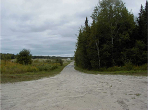
Photo 1: View of Cranberry Road from the tertiary road at the northern boarder of the Conservation Reserve
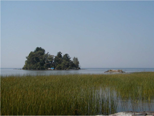
Photo 2: Aquatic emergent vegetation in Callander Bay
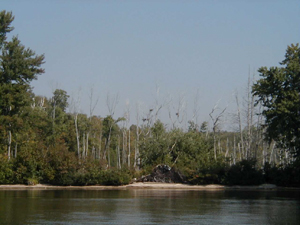
Photo 3: Heron nesting area in Callander Bay
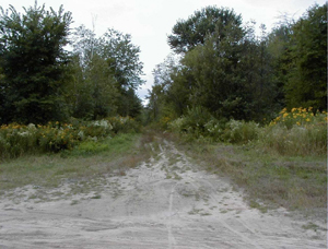
Photo 4: Informal trail leading into Callander Bay Wetland Conservation Reserve
Appendix 1 – Procedural Guideline B – Land uses – Test of Compatibility (PL Procedure 3.03.05)
The Conservation Reserve policy provides broad direction with regard to the permitted uses. The policy provides only an indication of the variety of uses that will be considered acceptable in Conservation Reserves. The only caution is that "any new uses, and commercial activities associated with them, will be considered on a case by case basis, and, they must pass a Protected Areas Test of Compatibility to be acceptable."
What does a ‘Protected Areas Test of Compatibility’ mean?
An examination of this must start from the premise of why an area is set aside – specifically, its representative natural heritage values. Criteria are then identified to guide compatibility considerations. These criteria apply to the long-term acceptability of both existing uses and new uses.
-
Conformity to SCI/RMP: SCI describe values for which an area has been set aside and the range of appropriate uses that will be permitted in the area. SCI may also speak to the acceptability of other ‘new' uses currently not occurring in the area.
The first 'test' is: "do proposed new land uses and/or commercial activities conform to the direction of the SCI/RMP for the Conservation Reserve? Would the new use(s) depart from the spirit of appropriate indicator land uses in the SCI/RMP?"
- Impact Assessment: If the proposed use(s) pass test 1 it is important to determine their impact on the area before they are approved. This should include the following:
- Impact on natural heritage values: "will the new use(s) impact any natural values in the area? If so how and to what degree? Is it tolerable?"
- Impact on cultural values: "will the new use(s) impact an historical or archaeological values in the area?"
- Impact on research activities: "will the new use(s) affect research activities in the area?"
- Impact on current uses: "will the new use(s) have any negative impact on the array of current uses?"
- Impact on area administration: "will the new use(s) increase administrative costs and/or complexity?" (For example, the cost of area monitoring, security and enforcement).
- Impact on accommodating the use outside the Conservation Reserve: "Could the use(s) be accommodated as well or better outside the Conservation Reserve?"
- Impact on socio-economics of the area: "will the new use(s) affect the community(ies) surrounding the area in a positive or negative way?" (For example, will the new use make an area less remote thereby affecting a local tourism industry that is dependent on the area’s remoteness for its appeal?"
- Impact on area accessibility: "does the new use(s) give someone exclusive rights to the area or a portion of the area to the exclusion of other existing uses?"
The following table provides a guide of indicator uses for the consideration of uses that may be permitted within Conservation Reserves. For any specific Conservation Reserve that Protected Areas Test of Compatibility should be applied to determine which specific uses are acceptable.
Appendix 2 – Public Lands Act Policy (3.03.05) Conservation Reserve Permitted Use table
Indicator uses for conservation reserves
Recreation
| Permitted activities | Generic existing | Generic new | (C149) Specific |
|---|---|---|---|
| Sport fishing | Yes | Yes | Yes |
| Sport hunting | Yes | Yes | Yes |
| Food gathering | Yes | Yes | Yes |
| Facility infrastructure | Maybe | Maybe | Maybe |
| Non-trail snowmobiling | Maybe |
Maybe |
Maybe |
| Non-trail ATV use | Maybe |
Maybe |
Maybe |
| Rock climbing/caving | Maybe | Maybe | N/A |
| Canoeing/kayaking | Yes | Yes | Yes |
| Motorized boating | Yes | Yes | Yes |
| Picnicking | Yes | Yes | Yes |
| Camping | Maybe | Maybe | Yes |
| Trails | Yes | Maybe | Maybe |
| Hiking | Yes | Maybe | Maybe |
| X country skiing | Yes | Maybe | Maybe |
| Cycling | Yes | Maybe | Maybe |
| Horse riding | Yes | Maybe | Maybe |
| Snowmobiling | Yes | Maybe | Maybe |
Science, education & heritage appreciation
| Permitted activities | Generic existing | Generic new | (C149) Specific |
|---|---|---|---|
| Research | Yes | Yes | Yes |
| General walking | Yes | Yes | Yes |
| Photography and painting | Yes | Yes | Yes |
| Wildlife viewing | Yes | Yes | Yes |
| Outdoor education/interpretation | Yes | Yes | Yes |
| Collecting | No | No | No |
Commercial activities
>
| Permitted Activities | Generic existing | Generic new | (C149) Specific |
|---|---|---|---|
| Food harvesting | Maybe | Maybe | No |
| Fishing | Maybe | Maybe | No |
| Baitfish harvesting | Yes |
Maybe | Yes |
| Trapping | Yes |
Maybe | Yes |
| Trap cabins | Yes | No | No |
| Resort-outpost camp | Yes |
No | No |
| Outfitting-bear management | Yes |
No | Yes |
| Wild rice harvesting | Yes | Maybe | No |
Resource management
| Permitted activities | Generic existing | Generic new | (C149) Specific |
|---|---|---|---|
| Inventory monitoring | Yes | Yes | Yes |
| Featured species management | Maybe | Maybe | Maybe |
| Natural systems management | Maybe | Maybe | Maybe |
Industrial activities
| Permitted activities | Generic existing | Generic new | (C149) Specific |
|---|---|---|---|
| Tmber harvesting | No | No | No |
| Prospecting | No | No | No |
| Mining | No | No | No |
| Hydro generation | No | No | No |
| Energy transmission corridors | Yes | No | No |
| Communications corridors | Yes | No | No |
| Transport corridors | Yes | No | No |
| Resource roads (MNRF) | Yes | No | No |
| Land disposition | No | No | |
| Hunt camps | Yes |
No | No |
Appendix 3 – Glossary of terms
Biodiversity: The number and variety of organisms found within a specified geographic region2
Biological Control: Control of pests by disrupting their ecological status, as through the use of organisms that are natural predators, parasites, or pathogens. Also called biocontrol2
Bog: Peat-covered areas or peat filled depressions with a high water table and a surface carpet of mosses, chiefly Sphagnum9
Calcareous: Composed of, containing, or characteristic of calcium carbonate, calcium, or limestone; chalky2
Canadian Shield: One of the world’s largest, low relief areas in the Earths crust that are composed of Precambrian crystalline rock, centered on Hudson’s Bay and extending for 8,000,000 square km1
Catchment: An area occupied by a closed drainage system, especially a region that collects surface runoff and contributes it to a stream, lake or other body of water. Also known as watershed or drainage basin9
Crown Land: Land owned by the provincial or federal government9
Cultural Heritage: Collective term describing examples of a society’s evolution (e.g. history, anthropology and archaeology) worthy of study and preservation5
Cultural Resources: Sites, features or artifacts related to the Province’s archaeology, anthropology or history, preserved in a natural setting5
Delta: A usually triangular alluvial deposit at the mouth of a river or a similar deposit at the mouth of a tidal inlet, caused by tidal currents2
Dredge: Any of various machines equipped with scooping or suction devices and used to deepen harbors and waterways2
Ecodistrict: An ecological landscape unit (ranging in resolution in hundreds of square kilometres) characterized by a distinct patterns in landform8
Ecoregion: An ecological landscape unit (ranging in resolution from hundreds of thousands to tens of thousands of square kilometres) characterized by distinct patterns of responses to climate as expressed by soils, hydrology, vegetation (species ranges and productivity), and fauna7
Ecosystem: An ecological community together with its environment, functioning as a unit2
Emergents: Herbaceous plants which rise out of the water9
Endangered Species: Species listed in regulation under Ontario’s Endangered Species Act. These species are threatened with extirpation from the province and in some cases extinction on a global basis9
Fen: Peatland characterized by surface layers of poorly to moderately decomposed peat, often with a well-decomposed peat near the base9
Ferric: Containing iron
Gley: A compact, sticky blue grey or olive grey soil horizon formed under wet conditions4
Gneiss: A crystalline rock, consisting, like granite, of quartz, feldspar, and mica, but having these materials, especially the mica, arranged in planes, so that it breaks rather easily into coarse slabs or flags2
Granite: A common, coarse-grained, light-colored, hard igneous rock consisting chiefly of quartz, orthoclase or microcline, and mica, used in monuments and for building2
Grenville Province: The area of Precambrian bedrock composed of certain metasedimentary and metavolcanic rocks located in the Canadian Shield or Georgian Bay-Ottawa Valley region4
Herpetofaunal: Pertaining to animals that are amphibians and reptiles
Humic: Of, relating to, or derived from humus2
Hydrology: The science of water, its properties and laws, and its distribution over the earth’s surface9
Igneous Rock: Any of various crystalline or glassy rocks formed by the cooling and solidification of molten earth material1
Interspersion: The measure or degree of edge contact, or ecotone length that exists between adjacent vegetation communities9
Intrusion: Body of igneous rock injected as magma into preexisting crustal rock10
Knob: Small prominent rounded hill or mountain of glacial drift10
Knoll: A small rounded hill or mound; a hillock2
Lacustrine: Of or relating to lakes2
Loam: Soil composed of a mixture of sand, clay, silt, and organic matter2
Magma: The molten rock material under the earth’s crust, from which igneous rock is formed by cooling2
Meso: In the middle; middle2
Metamorphic: Altered in physical structure or chemical composition by action of heat, pressure, shearing stress, or intrusion of elements, all taking place at substantial depth beneath the surface10
Migmatite: A rock that incorporates both metamorphic and igneous materials
Muskeg: A swamp or bog formed by an accumulation of sphagnum moss, leaves, and decayed matter resembling peat2
Nepheline: A mineral of sodium-aluminum or potassium-aluminum silicate, occurring worldwide in igneous rocks and used in the manufacture of ceramics and enamels2
Northern Wetland Evaluation System: A rationale and protocol for assessing wetlands in northern Ontario in order to rate wetland function and determine its relative significance for a given area. The system considers the functional role wetlands play in maintaining critical ecosystem functions, providing social benefits, improving hydrological systems and water quality as well as protecting rare species9
OBM: Ontario Base Map, refers to a geographic division of Ontario according to lines of longitude into mapsheets based on the UTM map projection system6
Outwash: Deposit of sand and gravel carried by running water from the melting ice of glacier and laid down in stratified deposits1
Palustrine: Wetlands with no or intermittent inflow and either permanent or intermittent outflow9
Patent: An exclusive right or title2
Peatland: The extensive areas of northern Ontario having organic soils9
Permeability: The property or condition of being permeable. The rate of flow of a liquid or gas through a porous material2
pH: A measure of the acidity or alkalinity of a solution, numerically equal to 7 for neutral solutions, increasing with increasing alkalinity and decreasing with increasing acidity. The pH scale commonly in use ranges from zero to fourteen2
Podzol: Type of soil in the Canadian soil classification system10
Precambrian: All of geologic time older than the Cambrian Period, that is, older than 600 million years10
Proterozoic: Of or relating to the later of the two divisions of Precambrian time, from approximately 2.5 billion to 570 million years ago, marked by the buildup of oxygen and the appearance of the first multicellular eukaryotic life forms2
Provincially Significant Species: The provincial rank is established by the Natural Heritage Information Center (NHIC). Listed species are based upon data and/or recommendations from a wide variety of sources including the Ontario Rare Breeding Bird Program Database, the Committee on the Status of Endangered Wildlife in Canada (COSEWIC), the Committee on the Status of Species At Risk in Ontario. A species is considered provincially significant if it is ranked as S1, S2, S3, SH or if it has been tracked by the NHIC. Species being tracked by the NHIC are generally known from fewer than 100 occurrences in Ontario and/or are COSEWIC or COSSARO designated9
Provincially Significant Wetland: Lands that are important on a provincial scale that are seasonally or permanently flooded by shallow water as well as lands where the water table is close to the surface; in either case the presence of abundant water has caused the formation of hydric soils and has favored the dominance of either hydrophytic or water tolerant plants9
Regionally Significant Species: Species that occur in a few populations or in very restricted distributions on a regional or local scale. Species selection is based on analysis of data from the Atlas of Breeding Birds in Ontario and Hills' Site Regions. Information has been updated by NHIC and specialists with expertise in breeding birds in their areas9
Sediment: Solid fragments of inorganic or organic material that come from the weathering of rock and are carried and deposited by wind, water, or ice2
Species of Special Significance: A species which has received the benefit of a great deal of data collection and may be considered as a possible indicator species. These species have been included for the purpose of additional monitoring9
Staging Area: Any area where migratory birds congregate to eat and rest prior to continuing their journey9
Syenite: An igneous rock composed primarily of alkali feldspar together with other minerals, such as hornblende2
Topography: Graphic representation of the surface features of a place or region on a map, indicating their relative positions and elevations2
UTM: Universal Transverse Mercator; a cylindrical projection used for the Ontario Base Map system4&6
1Encyclopaedia Britannica, Inc. 2002. Encyclopaedia Britannica Online.
2Dictionary.com. 2003. Lexico Publishing Group. www.dictionary.com
3Merriam – Webster. 2002. Merriam – Webster Online.
4Chapman, L.J, and D.F. Putnam. 1984. The Physiography of Southern Ontario, Third Edition. Ontario Geological Survey
5OMNR. 1992. Ontario Provincial Parks: Planning and Management Policies: 1992 Update. OMNR
6OMNR. 2001. Glossary.http://www.mnr.gov.on.ca/mnr/forests/forestdoc/ebr/fimpdfs/glossary.pdf (link no longer active)
7OMNR. 1996. Forest Management Planning Manual. Toronto: Queen’s Printer for Ontario
8Crins, William J and Peter W.C. Uhlig. 2002. Ecoregions of Ontario: Modifications to Angus Hills' Site Regions and Districts Revisions and Rationale.
9OMNR. 1993. Ontario Wetland Evaluation System Northern Manual
10Strahler, Alan and Arthur Strahler. 1997. Physical Geography Science and Systems of the Human Environment
Figure 1: Callander Bay Wetland Conservation Reserve Location map

Enlarge Figure 1: Callander Bay Wetland Conservation Reserve Location map
Figure 2: Callander Bay Wetland Conservation Reserve Forest Values map
Enlarge Figure 2: Callander Bay Wetland Conservation Reserve Forest Values map
Figure 3: Callander Bay Wetland Conservation Reserve Recreational Values & Tenure map

Enlarge Figure 3: Callander Bay Wetland Conservation Reserve Recreational Values & Tenure map
Footnotes
- footnote[1] Back to paragraph New uses will be considered on a case by case basis provided they do not impact the natural heritage values for which the area was established, and must pass a Protected Areas Compatibility Test to be acceptable.
- footnote[2] Back to paragraph For retrieval of game only
- footnote[3] Back to paragraph Existing dispositions will continue, however, as opportunities arise the Ministry will acquire and/or remove them outside of the conservation Reserve.
- footnote[*] Back to paragraph Transfer requests will be considered in the context of a Statement of Conservation Interest (SCI) or Resource Management Plan (RMP) for each Conservation Reserve.