Cedar Creek Conservation Reserve Management Statement
This document provides policy direction for the protection, development and management of the Cedar Creek Conservation Reserve and its resources.
Statement of Conservation Interest
Ministry of Natural Resources
Lakehead Area, Thunder Bay District
November 2000
Approval Statement
We are pleased to approve this Statement of Conservation Interest for Cedar Creek Conservation Reserve.
This Statement of Conservation Interest provides guidance f or the management of the conservation reserve and the basis for the ongoing monitoring activities. More detailed direction is not anticipated at this time. Should significant facility development be considered or complex issues arise requiring additional studies, more defined management direction, or special protection measures, a more detailed Conservation Reserve Management Plan will be prepared with full public consultation.
The public was widely consulted during the designation and regulation of the site and further consultation is not required at this time.
The conservation reserve will be managed under the jurisdiction of the Lakehead Area Supervisor, Thunder Bay District, Ministry of Natural Resources.
Signed by:
Charlie Lauer
Regional Director
Northwest Region
Dated: April 12, 2001
Jim Adams
Acting/District Manager
Thunder Bay District
Dated: April 2, 2001
1.0 Background Information
The purpose of this document is to identify and document the natural heritage values of Cedar Creek Conservation Reserve, the activities which occur there and, through a set of management guidelines, outline the activities which will and will not be permitted as well as the management direction for the area. For more information regarding this Statement of Conservation Interest (SCI) please refer to the "Conservation Reserve Policy and Procedure PL3.03.05", specifically pages 2–6 and 14–22 of the procedure.
Background Information
| Name | Cedar Creek Conservation Reserve |
|---|---|
| Site Region / Site District | 4W – 2 |
| OMNR Administrative Region / District / Area | Northwest Region / Thunder Bay District / Lakehead Area |
| Total Area (ha) | 279 ha Conservation Reserve and 65 ha Forest Reserve |
| Regulation Date | March 2001 |
| First Nations | Robinson Superior / Fort William First Nation |
| OBM | 20 16 2900 53600 |
| Latitude/Longitude | 48°26' N 89°44' W |
| Basemap | 484893 (NTS – 52A/5 – Scale 1:50 000) |
| Forest Resource Inventory Stands | 5775, 6477, 5176, 6381, 6283, 6683, 6587, 6884, 6988, 7482, 7581, 8180, 8682, 8783, 9280, 9382, 8488, 7990, 7488, 7090, 8191, 7693, 7794, 7796, 7295 |
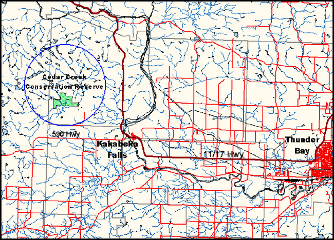
| General Location Description | Located approximately 10 km west of Kakabeka Falls in the municipality of Conmee, this site is located on parts of Concession 3 , lots 9 and 10 and Concession 2, lots 8, 10 and 11. Of note is Concession 2, lot 9, which is presently designated as Forest Reserve |
| Access | Follow Highway 11/17 North of Kakabaka Falls, turn left on Hunt Road West, right on Sovereign Road and then left on Olsen Road |
1.1 Representation Targets
This section provides a summary of the earth science, life science and cultural resource values, as well as present or possible recreational opportunities.
| Life Science Representation |
|
|---|---|
| Earth Science Representation |
|
| Cultural Resource Representation |
|
| Recreational Opportunities |
|
1.2 Survey Information
| Survey | Reconnaissance Inventory | Future Requirements |
|---|---|---|
| Life Science | Yes – Geowest, 2000 | No |
| Earth Science | Yes – Geowest, 2000 | No |
| Cultural | Values reviewed – 2000 | No |
| Recreational | Yes – 2000 | Monitor on an ongoing basis |
2.0 Values to be Protected
This section provides a description of the key natural heritage values on the site, their condition relative to past resource and management activities, and their sensitivity to future land use and management activities.
2.1 Values Identified on the Site
| Life Science |
|
|---|---|
| Earth Science |
|
| Cultural |
|
| Aboriginal |
|
| Tourism |
|
| Recreational Fishing |
|
| Recreational Hunting |
|
| Mining |
|
| Aggreggate |
|
| Forest Harvest |
|
| Trapping |
|
| Bear Management Areas |
|
| Bait Harvesting |
|
| Commercial Fish |
|
2.2 Values to be Protected
The intent of this SCI is to protect the following values by establishing management guidelines for existing and potential uses in this area given the level of past disturbance and the nature of the existing features.
2.2.1 Forest Values
The forest consists of a variety of cover types contributing to a diverse assemblage of wildlife habitats.
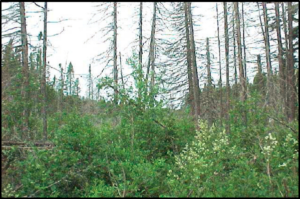
The western side of the conservation reserve has been disturbed by past logging activities with the regeneration consisting of 15 to 35 year old poplar (predominantly), and 15 year old white spruce (predominantly) stands. The remaining portions of the conservation reserve are primarily poplar, white birch and black spruce stands (75 to 90 years old).
The forest in the entire area will be protected from future forest harvest operations.
2.2.2 Landform Values
There are a variety of landforms that have contributed to the establishment of a variety of vegetation and forest cover types. This enhances the aesthetic appeal of Cedar Creek Conservation reserve and also provides the interspersion and juxtaposition of a diverse range of habitats.
Organic lacustrine–dominated areas are extremely susceptible to disturbance. Soil compaction and/or rutting may result in altered hydrological conditions that would impact local vegetation characteristics.
2.2.3 Recreational Values
The conservation reserve offers hiking, snow–shoeing, nature appreciation and sport hunting opportunities.
3.0 Management Guidelines
3.1 Land Tenure
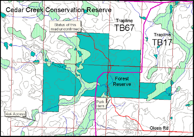
Cedar Creek Conservation Reserve consists entirely of Crown land. The Conservation Reserve is bounded by private land along its northern, eastern and southern boundary, with the western boundary currently in the possession of the Crown.
Cedar Creek Conservation Reserve will remain Crown land. No dispositions (including Land Use Permits or Licenses of Occupation) will be issued for the site.
The existing Forest Reserve (north half of lot 9, con 2) will be added to the conservation reserve if the claim is retired through normal processes.
Unauthorized occupations of lands within the conservation reserve will be handled in accordance with approved policy, and any required structural removal will be at the owner’s expense.
3.2 Existing and Proposed Development
At present there is only informal access to the conservation reserve. An existing road leads to the trail entrance along the southern boundary and can be reached by vehicle. However, the existing trail which passes just inside of the west boundary must be traversed by either ATV, snowmobile or on foot.
There are no existing campsites, privies, boat launches, parking lots or waste disposal sites within the conservation reserve.
As reported by Geowest Environmental Consultants Ltd., the existing trail passes over sensitive low–lying lacustrine and organic materials in the southern portion of the reserve. In an effort to protect the integrity of the hydrological regime, the trail will be closed to motorized vehicles in the spring, summer, and fall. The trail will only be open to motorized vehicles during periods of sufficient freezing to protect the soils from compaction and rutting. A sign will be posted at the trail entrance and the trail closure will remain in effect until an alternate trail, on an appropriate upland site, can be established. Trail use and compliance will be monitored on an ongoing basis.
Any new trails elsewhere in the conservation reserve may be considered if there is a demonstrated need, however they should be designed to discourage access by any means other than on foot.
Facility infrastructure and development for recreational and/or educational purposes may be considered in the future if there is a demonstrated demand for such facilities. A more detailed management plan would be required at that time.
All provincial policies which guide development (ie. water hazard management, shoreline development, wetlands) are applicable in conservation reserves as on Crown land.
3.3 Recreational Activities
Most recreational activities that have traditionally been enjoyed in this area can continue provided they pose no threat to the natural ecosystems and features protected by the conservation reserve. Non–regulated permitted uses include wildlife viewing, hiking, snow–shoeing and cross country skiing. Hunting and fishing will be permitted to continue as regulated uses.
3.4 Commercial Activities
The Cedar Creek Conservation Reserve is located within the Lakehead Forest and has been withdrawn from the Sustainable Forest License currently held by Greenmantle.
All lands within Cedar Creek Conservation Reserve and the adjacent Forest Reserve have been withdrawn from further staking by MNDM at the request of MNR. The Forest Reserve is designated as such due to an existing mining claim. The intent is that the claim area will be added to the conservation reserve if the claim is retired through normal processes.
Development of the mining claim located within the Forest Reserve may require access. It is noted that there may be limits to public travel if an access road is built. If there is a demonstrated need, public access alternatives will be reviewed at such a time.
This conservation reserve is part of two registered trap–lines (TB67 and TB17). Both are presently active and will be permitted to continue unless any significant demonstrated conflicts are identified. New trap–lines may be considered, however associated trap–line trails should be reviewed. There are no trap cabins located within the conservation reserve boundary and no new cabins will be permitted.
The area is not, and will not become, part of an active Bear Management Area and thus the hunting of bear is not allowed in this conservation reserve.
The conservation reserve is part of a licensed bait block (#37). Bait harvesting will be permitted to continue.
No other commercial activities exist in the area. No new activities, such as mining, commercial logging, hydro–electric power development, new transmission lines (e.g. power or communications), pipelines, highways or roads, and the extraction of aggregate, soil or peat, will be permitted.
3.5 Aboriginal Interests
There is no known past or current aboriginal interest in the Cedar Creek Conservation Reserve. Nothing in this Statement of Conservation Interest affects in any way existing or future aboriginal or treaty rights.
3.6 Natural Resources Stewardship
Natural Resource Stewardship involves the consideration of the following specific natural resource management categories.
3.6.1 Vegetation Management
Management within the conservation reserve will allow for the continuation of natural ecosystem processes and functions with minimal human interference.
The forest in the entire area is to be protected from any human alteration and forest fire protection will be carried out on the conservation reserve as on surrounding public lands and with a "light on the land" approach (ie. no bulldozers, no camp construction, minimal tree cutting).
Forest insect and disease management will continue as on surrounding Crown lands.
3.6.2 Fish and Wildlife Management
Existing Wildlife Management Unit, and sport fishing and hunting regulations and management activities will apply.
3.6.3 Landforms
There are a variety of landform types within Cedar Creek Conservation Reserve including; weakly to moderately broken bedrock with thin morainal veneers, thick upland morainal deposits, coarse to fine textured lacustrine materials, deltaic and outwash sands, and organic accumulations of variable thickness.
No management activity is required except protection.
3.7 Cultural Resources Stewardship
No management activity is required at this time based on existing information.
3.8 Client Services
Given the focus on low key management, client information will be given on an inquiry basis only and will deal with the basic level of information with respect to access, natural heritage appreciation, recommended activities and boundaries.
3.9 Research
Non–destructive research by qualified individuals will be encouraged to provide a better understanding of the natural values protected by the conservation reserve and to advance protection, planning and management.
All research programs will require the approval of the Ministry of Natural Resources as will the removal of any natural or cultural specimen. The establishment of permanent plots, observation points or facilities must also be approved and be compatible with the conservation reserve protection objective. Any site disturbed by research activities must be rehabilitated as closely as possible to its previous state.
3.10 Marketing
Awareness of the conservation reserve is promoted primarily through the Living Legacy web site and intensive marketing activity to increase use is neither desired nor required at this time.
4.0 Implementation
These management guidelines are to be implemented by the Lakehead Area Team, Thunder Bay District. Any affected clients will be immediately informed of proposed changes to this Statement of Conservation Interest.
5.0 Review and Revisions
5.1 Review and Revisions
Cedar Creek Conservation Reserve Statement of Conservation Interest will be reviewed on an ongoing basis. If changes in management direction are needed at any time, the significance of the changes will be evaluated and consultation may be required, as determined by the Area Supervisor. Any major amendments will require full public consultation and the approval of the District Manager and Regional Director.
This Statement of Conservation Interest complies with all requirements of the Environmental Assessment Act and the Environmental Bill of Rights. Environmental Assessment Declaration Order MNR – 65, dated February 2, 2000, permits designation of specific listed areas as Conservation Reserves, and allows for interim management of those areas. The undertaking of management of the Conservation Reserve will be in conformity with this policy and all other existing Crown land E.A. exemptions.
5.2 Public Consultation
5.2.1 Results of Past Consultation
Consultation on the proposed Cedar Creek Conservation Reserve was conducted as part of the consultation on the Ontario’s Living Legacy Land use Strategy, July 1999. Subsequent consultation also took place in 2000 to refine the boundary of the Conservation Reserve.
A pre–consultation letter was sent to Fort William First Nation in June 2000, followed by a formal "invitation to participate" in August 2000. District staff met in November 2000 with the Chief, band Manager and Land Claim Representative. Cedar Creek is within the traditional use area of the Fort William First Nation.
A district information package was distributed to known interested and affected people in August 2000 with an "invitation to participate" newspaper advertisement placed in the local paper. Public inquiries and one comment were received. The comment reflected concern that the conservation reserve had significant mineral potential and the subject strongly opposed the regulation of the site. No other issues were identified.
5.2.2 Present and Future Consultation
More widespread consultation is not deemed necessary at this time.
5.2.3 Authors
This Statement of Conservation Interest was prepared by Tracy Moore, OLL Resource Manager Intern, Thunder Bay District.
6.0 References
Holenstein, Julian. 1997. Fish habitat Mapping Project. Thunder Bay; Northern Bioscience Ecological Consulting.
Land Resource Research Institute, 1981. Soils of the Thunder Bay Area. Soil Survey Report 48 – Kakabeka Falls 52 A/5. Department of Energy, Mines and Resources.
Natural Heritage Information Centre, 2000. /page/natural-heritage-information-centre
Ontario Ministry of Natural Resources, 1997. Conservation Reserve Policy and Procedure. PL 3.03.05. 22 p.
Ontario Ministry of Natural Resources, 1999. Ontario’s Living Legacy – Land Use Strategy. 136 p.
Ontario Ministry of Natural Resources, 1989. Thunder Bay District Fisheries Management Plan 1988 – 2000. 104 p.
Ontario Ministry of Natural Resources, 1983. Thunder Bay District Land Use Guidelines. 108 p.
Ontario Ministry of Natural Resources, 2000. NRVIS – Natural Resource Values Information System.
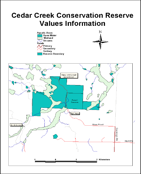
Appendix A – Regional Setting
Appendix B – Conservation Reserve Map
Appendix C – Photos
Black Spruce Swamp
Open Water Photo 1
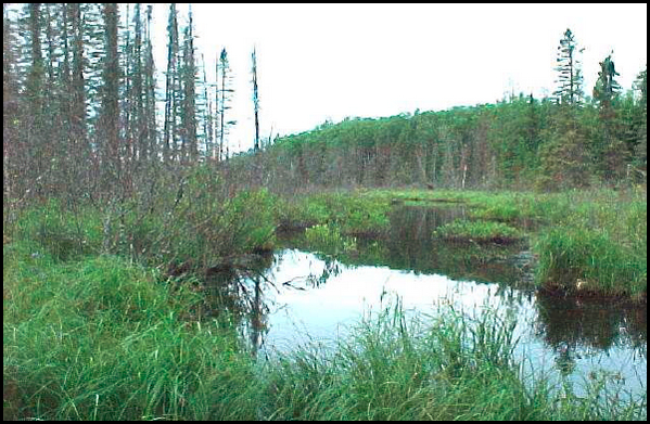
Open Water Photo 2
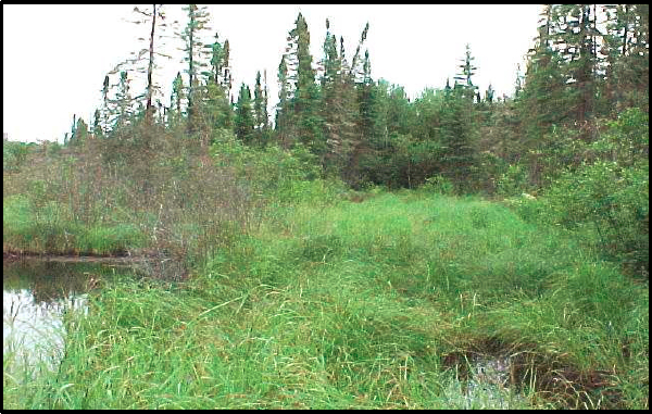
Southern Trail
Appendix D – Recreational Inventory Checksheet
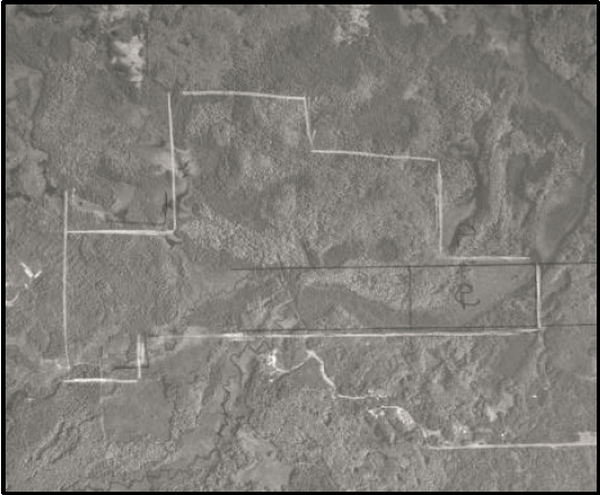
Cedar Creek Conservation Reserve – C2267
1992 Air Photo with Conservation Reserve boundary outlined (not exact)
Township: Conmee
County: Municipality of Conmee
Employee Name: Tracy Moore
Date: July 26, 2000
Description of Site: This recreational inventory is for Cedar Creek Conservation Reserve in Conmee Township. The conservation reserve is approximately 344 ha, and is located within the Great Lakes – St. Lawrence Forest Region (Hills, 1997) of Thunder Bay District.
The Cedar Creek system lies within the Whitefish River watershed. The site contains representative landform types for the region which include strongly broken end moraine and strongly broken ground moraine (LUS, 1999). Within the boundary of the Conservation Reserve and in addition to the ground moraine, are areas of both low and moderate relief, wet and dry areas, and organic terrain (Mollard, NOEGTS 1979).
Of note are the dominant deciduous and deciduous–mixed forest stands (There is a significant amount of poplar).
For more information on the earth and life science features represented at Cedar Creek Conservation Reserve see the report prepared by Geowest Environmental Consultants Ltd.
Methodology: This inventory was compiled with the use of aerial photos, maps, area reports (values information, FRI, fisheries information) and two site visits.
Field Notes: Two field visits were conducted to examine the status of access trails. A brief on foot field visit was conducted in July 2000 to examine the south side access trail. It was found to be very wet in several areas. A brief field visit to examine the west side of the conservation reserve revealed active beaver ponds, heavy green alder growth along the trail, and young (< 20 yr) poplar stands. There was also evidence of waterfowl hunting.
Part 1 – Basic Recreation Opportunities
| Recreational / Scenic Features | Permitted? | Comments/Details |
|---|---|---|
| Backcountry camping | No | |
| Canoeing | Yes | The rivers and streams running through the conservation reserve offer the potential for canoeing. However, the depths and amount of beaver activity is unknown. |
| Hiking | Yes | Trails that can be used for hiking, enter the conservation reserve from two informal access points. |
| Hunting | Yes | Opportunity exists for waterfowl, large game and upland species hunting. Numerous shotgun shells were found within the boundaries of the site. |
| Fishing – Recreational | Yes (low potential) | Cedar Creek Conservation Reserve lies within the headwaters of the Whitefish River watershed. Cedar Creek has been described as a cold water river/stream in which rainbow trout, brook trout and smallmouth bass have been recorded (District Fisheries Summary, 1997). It is unsure whether or not the waters are navigable through the reserve or whether or not the habitat for trout or bass exists within the reserve boundaries. |
| Lakes | No | Areas of open water do exist along the Cedar Creek waterway (see Photo # 2). These are primarily due to past and present beaver activity and seasonal fluctuations. |
| Swimming Opportunities | No | |
| Beaches | No | |
| Rapids/Waterfalls | No | |
| Nature & Wildlife Viewing | Yes | The 50 to 90 year old predominantly deciduous stand provides a pleasant atmosphere for hiking and enjoying nature. The variety of upland and wetland sites also provides habitat for a number of wildlife species. While conducting the field visits for Cedar Creek Conservation Reserve, marten, kingfisher and grouse were seen. There were also signs of black bear (tree marks, scat), moose (tracks) and deer (tracks). |
Summary of Area Description and Land Use Intent provided in Appendix A of the Land Use Strategy, July 1999, with specific reference to recreation uses and features:
Area Description – This site contains representative landform and vegetation types, including deciduous and mixed forests on strongly broken end and ground moraine.
Land Use Intent – None provided.
Additional Comments – Ministry maps indicate wetlands and ponding along the Cedar Creek waterway, parts of which are within the Cedar Creek Conservation Reserve boundary. The depth of the waterway is unknown. Cedar Creek has been classified as cold water stream (District Fisheries Summary, 1997) with both trout species and bass being recorded. The existence of these species living within the same system is very uncommon and doubtful.
Recommendations – Further exploration of the stream system will serve to better define the status of a canoe route, fishing opportunities and potential for waterfowl hunting. It is also recommended that further examination of the Cedar Creek system be undertaken to determine the thermal classification and fish species.
Summary of 'Canada Land Inventory – Land Capability for Recreation':
(From: A Ready Reference – Ontario Land Inventory; Jan. 1977; pg. 39–52)
Canada Land Inventory (maps at scale 1:50,000) have a 3 unit code.
- First figure is a capability class that ranges from 1–7 (very high to very low capability for outdoor recreation)
- Second Unit – 2 categories – shoreline (S) and upland (U)
- Third figure is a subclass code of a feature that provides opportunity for recreation. The first code denotes main feature based on intensity of use
The CLI divides Cedar Creek Conservation Reserve into two classified polygons – 6UOW and 6UOQ. Class 6 – Low capability for outdoor recreation, is defined as land lacking the natural quality and significant features to rate higher, but having the natural capability to sustain low annual use, based on dispersed activities. The subclass codes define the area as upland, affording the opportunity for viewing upland wildlife (O), and wetland life (W). The topography or land water relationships enhance opportunity for general outdoor recreation, such as hiking and nature study (Q).
Part 2 – Human Influence
| Activity/Features | Permitted? | Comments/Details |
|---|---|---|
| Established Campsites | No | |
| Established Canoe Routes | No | |
| Portages | No | |
| Existing Formal Access Point (Road & Parking) | No | |
| Existing Informational Access Points | Yes | # Access points – 2
|
| Established Hiking Trails | Yes | South Trail – This trail is accessed from Point #1 above. A brief on foot field visit revealed that the trail is very wet in several areas (see Photo # 3), however in the upland area the trail passes through a 50 to 80 year old predominantly deciduous stand. It is unclear exactly how far this trail extends into the reserve. Although the extent of the trail walked and tracked (GPS) does not correspond with ministry maps, it does appear in air photos. West Trail – This trail is accessed from Point #2 above and passes only a short distance within the boundary of the reserve. The trail passes active beaver ponds, heavy green alder growth, and young (< 20 yr) poplar stands. It is a primarily upland and therefore dry trail. |
| Snowmobile Trails | Yes | #Trails – 2 The trails above can be used for snowmobile access to the conservation reserve. The closest official trails of the Ontario Federation of Snowmobile Clubs (OFSC) lie to the south (2 km) and west (6 km) of the Cedar Creek Conservation Reserve. |
| ATV Trails | Yes | #Trails – 2 It is questionable whether or not a quad could traverse all areas during times of high water levels. |
| Existing Boat Caches | No | |
| Hunt Camp | No | |
| Trapping | Yes | #Trails – 2 Trap line ID #’s – TB76 and TB17. There is flagging within the reserve, which may possibly denote trap line trails or hunting trails. A search of area files reveals that trapper success has included beaver, mink, marten, fisher, weasel, fox, and timber wolf. |
| Trapper Cabins | No | |
| Bear Management Area | No | |
| Bait Harvesting | Yes | Cedar Creek Conservation Reserve lies within one licensed bait block (# 37). |
| Resort/Lodge in Park | No | |
| Resort/Lodge Adjacent | No | |
| Outpost Camp in Park | No | |
| Outpost Camp Adjacent | No | |
| Historic Sites/Structures | No | |
| Mining | Yes | Bound on three sides by the Conservation Reserve is a Forest Reserve (F2267) (see attached map). The claim number is #1210461 and is due to expire April 23, 2001. Upon expiry the Forest Reserve will be absorbed by the conservation reserve. For more details regarding Forest Reserves and permitted uses see page 23 of the OLL Land Use Strategy, 1999. |
| Mining Adjacent to Park | Yes | A claim stake was found along the western border of the reserve. The stake was for former claim #1205183 that expired April 99. It was replaced by claim #1209595 and is due to expire at the end of April 2001. |
| Current Mining Exploration | No | |
| Evidence of Exploration | Yes | An old mining claim stake was found within the boundaries of the reserve. This previous mine claim has since been replaced, is held by the same individual, and is adjacent to the reserve. |
| Inholdings | No | |
| Transmission Lines | No | |
| Rights–of–way | No | |
| Towers | No | |
| Wild Rice Harvesting | No | |
| Water Impoundment | No | |
| Roads | No | The trail from the south access point is shown as a secondary road on district maps. This road has been referred to within this recreation report as a trail due to its condition. |
Additional Comments:
Although not directly adjacent to the Conservation Reserve, there is a small proportion of agriculture activity within the Cedar Creek watershed.
Recommendations:
This site should be revisited in the winter to determine the extent of the trail use by snowmobiles, and to follow and track (GPS) the main trail from the south access point to the end.
Appendix E – Earth Science Checksheet
(completed by Geowest Environmental Consultants)
Earth Science Inventory Checklist
Name: Cedar Creek Conservation Reserve
National Topographic Series
| Name | Cedar Creek Conservation Reserve |
|---|---|
| Map Name | Kakabeka Falls |
| NTS Number | 52A05 |
| UTM Reference | 5369000 N 298000 E |
| OBM Number | 162905360 |
| Latitude | 48° 25' |
| Longitude | 89° 44' |
| Elevation - Max | 470 |
| Elevation - Min | 440 |
| County | District of Thunder Bay |
| Township | Conmee |
| Lot/Concession | S 1/2 Lot 10, Concession 3 S 1/4 Lot 9, Concession 2 N lot line for Lot 11, Concession 2 N 1/2 Lot 9, Concession 2 N 1/2 Lot 10, Concession 2 NW 1/4 Lot 11, Concession 2 |
| Area | 275 ha |
| Ownership | Crown |
| Aerial Photographs (Year/Roll/Flight Line/Number) | 92/4815/20/200,201,202 |
| MNR Region | Northwest |
| MNR District | Thunder Bay |
| Park Zone | Thunder Bay |
| Survey Type | Reconnaissance |
Earth Science Features
The Cedar Creek Conservation Reserve (C2267) is approximately 35 km west of the City of Thunder Bay, Ontario. It is a relatively small area (275 ha) and is characterized by gently undulating to strongly rolling uplands with mixedwood forests and open fluvial meadows in lower positions.
Cedar Creek is part of the larger, but poorly defined Brule Creek watershed. Waters flows east from Adrian Township into the Conservation Reserve where it appears that the water flows in subterranean channels along a relict meltwater channel (through the north half of lots 9 and 10 concession 2) to a large recharge area and then north into Brule Creek. The undulating and rolling topography results in numerous small ponds, unnamed lakes, poorly defined stream channels and wetlands within Cedar Creek and Brule Creek watersheds. These two systems flow into the Kaministikwia River system.
The Cedar Creek Conservation Reserve is found in the Wawa Subprovince of the Superior Structural Province (Card et. al., 1993; Williams et. al., 1992). The Superior Province is the largest Archean craton in the world and is characterized by easterly trending belts of Archean supracrustal volcanic and sedimentary rocks separated by large areas of granitic rocks (Thurston 1992b; Davidson 1981). The Wawa Subprovince is an aggregation of Archean greenstone belts and granitoid plutons; it is a granite–greenstone terrane in which disparate units, and well–defined greenstone belts of metamorphosed komatite, basalt, dacite and ryholite and associated metasedimentary rocks, are dispersed in a sea of granitoid rocks (Williams et. al., 1992; Ontario Geological Survey 1991b). Parker (1977) defines greenstone belts as oceanic and islands arclike sequences (Parker 1997). It is suggested by Williams et. al. (1992) that in the Cedar Creek area, Archean rocks are overlain with marked angular unconformity by flat–lying Proterozoic sedimentary rocks of the Animikie Basin, and diabase sills of the Nipigon Embayment. For the most part, the bedrock is overlain by thick post–glacial sediments and does not influence site characteristics.
Labrador Sector ice of the Laurentide ice sheet covered the Cedar Creek area between 18 ka before present (ka BP) and ~ 10.5 ka BP. Barnett (1992) suggests that the area became ice free between 11 and 10 ka BP (this is approximately 1,200 – 2,200 years later than suggested by Prest (1968)). Prest (1968) suggests that a short–lived cold period, known as the late Wisconsinan Algonquin Stadial, is responsible for most of the sediments within the Cedar Creek area. This "stadial" occurred between 11 and 10 ka BP.
Zoltai (1963) and Barnett (1992) suggest that the Cedar Creek area may have been at the upper margins of glacial Lake Kaministikwia (maximum elevation of 470 m). Clay–rich, varved lacustrine sediments within the Cedar Creek Conservation Reserve (~ 425 – 500 m above sea level) suggest that these deposits were, in fact, part of glacial Lake Kaministikwia. The outwash/deltaic deposits (and associated spillway–like feature) found along the southern boundary of the Conservation Reserve support this hypothesis.
The gap analysis suggests that the Cedar Creek Conservation Reserve is characterized by a mix of weakly to moderately broken end moraine and moderately to strongly broken ground moraine. Mollard and Mollard (1983) and Barnett et. al., (1991) have mapped the area as being comprised of sandy and silty morainal materials, organics and deltaic deposits. Zoltai (1965a) has mapped the area as silty to sandy ground moraine with a major end moraine marking the southern boundary of the Conservation Reserve. Although Zoltai (1965a) does not indicate any glacial straie in the Cedar Creek Conservation Reserve itself, he has mapped numerous straie in the surrounding area suggesting numerous advances and re–advances of ice across the landscape from a number of directions.
Zoltai (1963) has identified two terminal moraines in the Cedar Creek area, including the Brule Creek moraine and the Marks moraine. He describes the Brule Creek moraine as "consisting of poorly sorted and unsorted bouldery, sandy material of irregular topography…the thickness of the deposits is variable, with knolls of morainic materials alternating with bedrock hills having only a thin till cover." Conversely, he defines the Marks moraine as consisting mainly of diabase and shale derived from late Precambrian bedrock formations further to the east…this contrasts sharply with the granitic ablation till beyond the moraine." The till in the Cedar Creek area appears to more reflect the characteristics associated with the Brule Creek moraine.
Field work by Geowest suggests that the area is considerably more complex, consisting of weakly to moderately broken bedrock with thin morainal veneers, thick upland morainal deposits, coarse–to fine–textured lacustrine materials, deltaic and outwash sands and organic accumulations.
Weakly to moderately broken bedrock occurs in the northern portion of the Conservation Reserve. The bedrock is overlain by thin (and often discontinuous) morainal. The till materials are comprised of a sand loam matrix with up to 45 % angular and subangular fragments. Much of the till has been washed of steeper slopes, exposing bedrock materials. These materials are well drained with slopes up to 35 %. Numerous small erratics are found on the surface.
Weakly broken ground moraine (ablation till) dominates the eastern section of the Conservation Reserve. Although no sites were established within this unit, it is assumed that the till is comprised of a sandy/silt matrix with similar coarse fragment content to that described above. The topography in this unit is relatively subdued with slopes less than 15 %. The unit is not bedrock controlled. Soils appear to be well to moderately well drained. A large organic area occurs in the middle of this unit.
Lacustrine materials dominate the remaining area within the Conservation Reserve. These deposits are stone free and vary from imperfectly drained clays to well drained loamy sand and fine sands. Mixedwood and deciduous–dominated vegetation is associated with the coarser–textured lacustrine materials, while coniferous–dominated mixedwood and coniferous stands are associated with the finer–textured lacustrine deposits. Within the finer–textured deposits, the materials are massive with varves evident. Within the coarser–textured materials, the materials are single–grained, with finer–textured clays and silty clays generally occurring within 100 cm of the surface.
Outwash sands (4d) were noted along the southern boundary of the Conservation Reserve. These deposits are evident immediately south of the boundary (near the end of the road). A major outwash channel is very evident from the air photos running along the southern boundary of the Conservation Reserve. Outwash materials are overlain by thick organic accumulations.
Within and immediately adjacent to the stream channels, thin organic veneers have developed (8b) on fluvial lacustrine materials. These materials tend to be poorly drained fluvial lacustrine materials that support Calamagrostis spp. communities. Upland organics are quite deep and often exceed 65 cm.
Sensitivity
Township roads running north from Secondary Highway 590 provide access to the Cedar Creek Conservation Reserve. Within the Conservation Reserve area, access is limited to a trail that runs from the south in a north/northwest direction. It provides access to a recent cutblock north of the Conservation Reserve. It appears that 4x4 quads for recreational activities use this trail as numerous ruts were observed during the inventory.
The organic (8b, 8c) and finer–textured lacustrine–dominated areas (4a) are sensitive to disturbance, especially rutting and compaction. This is primarily due to seasonally high water tables (as evident in early October), clay–rich lacustrine materials and thick organic accumulations. Soil compaction in lowland areas may result in altered hydrological conditions that may impact local vegetation characteristics. For the most part, the trail that passes through the Conservation Reserve is found on drier upland lacustrine (4b), till (1a), and bedrock (7b, 7c) dominated areas. Any additional trails should be located in the upland areas to reduce the potential for rutting and soil compaction.
Recommendations
The Cedar Creek Conservation has been recognised as having "representative landform and vegetation types, including deciduous and mixed forests on strongly broken end moraine and ground moraine" (OLL 1999). While the above was found, the Cedar Creek area also provides representative examples of lacustrine and outwash sediments associated with glacial Lake Kaministikwia. It is recommended that the Cedar Creek Conservation Reserve be protected, as it is provides strong evidence of the Late Wisconsinan (morainal deposits) and Holocene (lacustrine and outwash sediments) periods.
Because the trail passes over sensitive low–lying lacustrine and organic materials, it is suggested that motorized access be eliminated from the area during non–winter months. This precludes both 2–wheel and 4–wheel drive vehicles, as well as quads. Access should be limited to walking in the spring, summer and fall months and walking, skiing, snowshoeing and skidooing in the winter months.
Appendix F – Life Science Checksheet
(completed by Geowest Environmental Consultants Ltd.)
Life Science Inventory Checklist
| Name | Cedar Creek Conservation Reserve (C2267) |
|---|---|
| Map Name | Kakabeka Falls |
| UTM Reference | 52A5 |
| Latitude | |
| Longitude | |
| NAD | |
| Minimum Altitude | |
| Maximum Altitude | |
| County | District of Thunder Bay |
| Locality | Thunder Bay |
| Township | Conmee |
| Area | 275 ha |
| Ownership | Crown |
| MNR Region | Northwest |
| Ecoregion and Ecodistrict | 4W-2 |
| Landform Unit(s) | Weakly to Moderately Broken Bedrock; Weakly to Moderately Broken Ground Moraine and End Moraine; Lacustrine Deposits; Deltaic and Outwash Deposits |
| MNR District | Thunder Bay |
| Aerial Photographs (Year/Roll/Flight Line/Number) | 92/4815/20/200,201,202 |
Physical and Biological Features
Representation
The Cedar Creek Conservation Reserve (C2267) is located approximately 35 km west of the City of Thunder Bay, Ontario. It is a relatively small site (275 ha) and is characterized by gently undulating to strongly rolling uplands with mixedwood forests and open fluvial meadows in lower positions.
The area is comprised of a diversity of upland forest and wetland vegetation types on a variety of landform types including weakly to moderately broken bedrock with thin morainal veneers, thick upland morainal deposits, coarse– to fine–textured lacustrine materials, deltaic and outwash sands, and organic accumulations of variable thickness.
The Cedar Creek site is part of the larger, but poorly defined Brule Creek watershed. Water flows east from Adrian Township into the Conservation Reserve where it appears that the water flows in subterranean channels along a relict meltwater channel (through the north half of Lots 9 and 10, Concession 2) to a large recharge area and then north into Brule Creek. The undulating and rolling topography results in numerous small ponds, unnamed lakes, poorly defined stream channels and wetlands within Cedar Creek and Brule Creek watersheds. These two systems flow into the Kaminsitikwia River system.
Deciduous–dominated mixedwood forest dominates upland, well–drained sites with lesser amounts of coniferous–dominated mixedwood forest and pure coniferous and deciduous forest communities. Deciduous stands and deciduous–dominated mixedwood stands are generally comprised primarily of either trembling aspen or white birch. Trembling aspen mixedwood stands (Vegetation Type V9 – Trembling Aspen Mixedwood; see Sims et al. 1997) generally have a variable component of associated tree species such as white birch, white and black spruce, balsam fir and jack pine. The understory is generally shrub and herb rich, comprised of species such Corylus cornuta, Diervilla lonicera, Alnus crispa, Vaccinium myrtilloides, Rubus idaeus, Cornus canadensis, Aster macrophyllus, Lycopodium spp., Clintonia borealis, Pyrola spp. and Calamagrostis canadensis. Moss cover is generally low with occasional patches of feathermosses such as Pleurozium schreberi and Ptilium crista–castrensis.
White birch dominated stands (Vegetation Type V4 – White Birch Hardwood and Mixedwood) also occur in the area, particularly adjacent fluvial areas and in association with terrain dominated by weakly broken bedrock overlain with thin morainal veneers. Canopy associates are white and black spruce and balsam fir. The understory cover is variable but is often dominated by species such as Corylus cornuta, Alnus crispa, Vaccinium spp., Diervilla lonicera, Cornus canadensis, Lycopodium spp., Clintonia borealis and Aster macrophyllus, as well as occasional patches of feathermoss.
Thin to moderately thick organic deposits occur in depressional sites overlying finer–textured lacustrine deposits, as well as on poorly drained, sandy, outwash channel materials along the southern boundary of the site. These stands are generally dominated by black spruce with occasional occurrences of jack pine, balsam fir, tamarack and white birch (Vegetation Type V33 – Black Spruce / Feathermoss, and Vegetation Type V36 – Black Spruce / Bunchberry / Sphagnum (Feathermoss). Ericaceous species typically dominate the understory with a prevalence of Ledum groenlandicum, Vaccinium myrtilloides, and Gaultheria hispidula. Common herbaceous species, with generally lower cover, include Cornus canadensis, Lycopodium spp., Linnaea borealis and Carex spp. The forest floor is primarily covered by a continuous mat of feathermoss with patches, often extensive, of Sphagnum spp.
Small open wetland sites (marshes and thicket swamps) with thin organic deposits also occur bordering fluvial channels. Species composition is variable but may include scattered, stunted black spruce and tamarack and occasional white cedar, with typical species such as Salix spp., Alnus rugosa, Cornus stolonifera, Calamagrostis canadensis, Carex spp. Equisetum fluviatile and various mosses.
Condition
This site is generally undisturbed except for the trail right–of–way that runs from the south in a north/northwest direction to the north boundary. It appears that ATVs have been used on the trail at various times in the past, but the wet conditions along numerous portions of the trail limit ATV and vehicle access during the summer.
Diversity
A variety of landform/vegetation complexes occur within the Cedar Creek Conservation Reserve. Upland forests are comprised of a variety of deciduous, deciduous mixed; conifer and conifer mixed stands. Sparsely vegetated bedrock outcrops occur sporadically in the northern portion. Landform types represented included weakly to moderately broken bedrock with thin, often discontinuous morainal veneers, weakly broken ground moraine, lacustrine deposits and sandy outwash deposits. Various wetland communities are also represented, varying from treed and semi–treed fens to marsh and open water marsh communities. Several small fluvial channels associated with Cedar Creek are also present.
Ecological Considerations
Vegetation cover within the site is characteristic of the surrounding area and is predominantly fire–origin, mature mixedwood forest. Aspect, soil thickness and soil drainage tend to influence forest species composition, with coniferous–dominated stands being more prevalent on north aspects and poorer drained depressional areas, and deciduous–dominated stands occurring more commonly on southerly aspects and upper slopes. Forest stands tend to be fairly mature throughout the site, with few younger age classes represented. The site tends to be relatively undisturbed with no evidence of recent timber harvesting or areas of significant tree blowdown.
The diversity of vegetation and forest cover types provide an equally diverse assemblage of wildlife habitats. Deciduous–dominated mixedwood stands provide excellent moose forage opportunities, while thermal habitats are afforded by coniferous–dominated mixedwood stands. The presence of ericaceous shrubs in the understory of mixedwood forest components also provides good habitat for black bear and smaller furbearers. OMNR records indicate that two registered traplines traverses the Cedar Creek
Conservation Reserve, on which beaver, mink, marten, fisher, weasel, colored fox, and timber wolf were the reported catches. The interspersion and juxtaposition of security, thermal, and foraging habitats for ungulates and furbearers is a key feature of this site. In addition, breeding bird diversity can be expected to be relatively high due to the diversity of habitats present.
Special Features
No evidence of vulnerable, threatened or endangered species, or "S" ranked species were encountered during the reconnaissance survey of the site.
Significance Level
Regionally Significant: The Cedar Creek Conservation Reserve provides a good example of mature, deciduous–dominated mixedwood forest on weakly broken ground moraine, lacustrine and outwash deposits as well as weakly broken bedrock overlain by thin (and often discontinuous) morainal materials. It is representative of upland areas within Site District 4W – 2.