

Inland lakes monitoring
Learn about how we use monitoring, including broad-scale monitoring, to study fisheries and fish populations in Ontario’s inland lakes.
Why monitoring matters
We monitor Ontario’s inland lakes regularly to understand the health of fish populations, aquatic habitats and the pressures affecting them. This work supports the sustainable management of fisheries across the province.
Long-term fisheries monitoring on inland lakes allows us to:
- collect data to inform policy decisions on fisheries management, biodiversity, species at risk and water quality
- analyze and report on the status and trends of fish populations and aquatic ecosystems to support fisheries management across Ontario
- detect changes due to stressors, such as climate change, invasive species and angling pressure
- provide anglers with up‑to‑date fisheries information through Fish ON‑Line
- support ongoing and innovative research at provincial, federal and international levels
- support development of management strategies and policies, for example, aquatic invasive species
How Ontario manages fisheries
Instead of managing lakes individually, we manage fisheries at a landscape level in fisheries management zones (FMZs).
This approach is guided by the following:
- Ecological Framework for Fisheries Management (EFFM) which emphasizes streamlined regulations, public involvement and landscape level monitoring (for example, broad-scale fish community monitoring).
- Ontario’s Provincial Fish Strategy: Fish for the Future which outlines how FMZ-level management works and when more intensive monitoring is needed (for example, provincially significant inland fisheries (PSIFs)).
How monitoring works
We monitor inland lakes and PSIFs on a 5-year cycle using standardized, internationally recognized methods. Monitoring in each cycle includes:
- about 650 inland lakes that are sampled once per cycle
- 12 PSIFs that may be sampled multiple times per cycle
Data is collected on:
- fish abundance (number of each species)
- species richness (number of different species in an area)
- age and size
- habitat features and lake characteristics
- water temperature, oxygen levels, water clarity and water chemistry
- stressors, such as climate change, angling effort and invasive species
Monitoring using a North American standard allows fisheries managers to compare between specific lakes, within FMZs and across Ontario. The data we collect is used by internal and external partners, including:
- academia
- Indigenous communities
- other areas within the ministry
- other ministries
- international counterparts
Broad-scale monitoring (BsM)
How lakes are selected
When broad-scale monitoring began in 2008, fixed lakes were randomly selected based on FMZ, lake size and whether they contained walleye, lake trout and brook trout.
There are 2 types of lakes within BsM:
- fixed lakes
- variable lakes
Fixed lakes
- must contain brook trout, lake trout or walleye
- are sampled once per monitoring cycle
- allow us to track long-term changes
Variable lakes
- are any lakes larger than 50 hectares that do not have species and habitat information collected
- are sampled once
- are used to document habitat, species presence and invasive species
What we measure
Fisheries indicators
Two types of standardized index gill nets are used:
- large mesh nets (North American standard) for fish larger than 20 cm (for example, walleye or lake trout)
- small mesh nets for juvenile sportfish and forage fish
From captured fish, we sample:
- length, weight, sex and maturity
- age structures (calcified bones such as ear bones)
- stomach contents
- tissue samples for contaminants
- species and counts for smaller fish
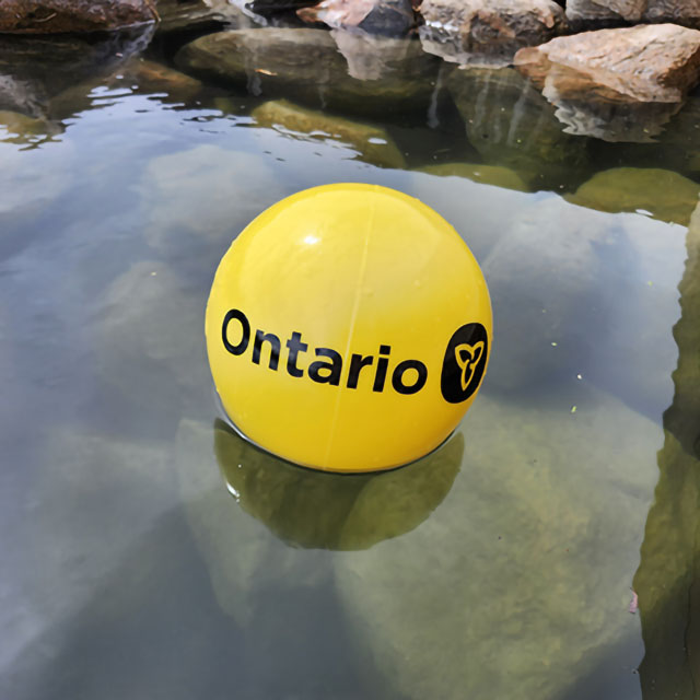
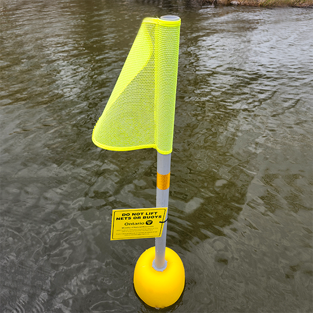
We set nets overnight and mark them with yellow buoys with the Ontario trillium logo. Users should avoid these areas and never lift the nets.
Contaminants
The Ministry of Environment, Conservation and Parks (MECP) analyze tissue samples through Ontario’s fish contaminant monitoring program and use them to update the Guide to Eating Ontario Fish.
Water clarity
We use a secchi disc, a small black and white disc lowered into the water until it is no longer visible, to measure how deeply light penetrates the water. This helps us assess nutrient levels and productivity.
Temperature and dissolved oxygen
We take measurements from the surface to the lake bottom to create profiles that show habitat suitability for species, such as lake trout, which require cold, oxygen‑rich water.
Depth (bathymetry)
We use depth sounders with GPS to map lake depth, volume and shoreline length. This helps us determine where to set nets and how to interpret fish data. Bathymetric data exists for nearly 10,000 lakes.
Water chemistry
Samples are collected within 4 weeks of ice‑off and are analyzed for:
- pH, alkalinity and conductivity
- nutrients, for example phosphorus
- electrolytes such as calcium, magnesium, sodium and potassium
- dissolved carbon
- nitrates and nitrites
Zooplankton
We collect samples at 3 lake locations to detect the presence of tiny invasive species, such as spiny waterflea or juvenile zebra mussels.
Report new detections
We report new detections to the publicly available Invading Species Awareness Program online or 1-800-563-7711.
Provincially significant inland fisheries (PSIFs)
Additional monitoring is done on 12 high-value fisheries:
- Grand River
- Lac Seul
- Lake Nipigon
- Lake Nipissing
- Lake of the Woods
- Lake Scugog
- Lake Simcoe
- Ottawa River
- Rainy Lake
- Rice Lake
- Tri Lakes
- Winnipeg River
Monitoring tools can include:
- open-water roving creels (boat-based)
- winter roving creels (by snowmachine) or access point creels
- angler diaries
- commercial catch reports
- mail-in surveys
- index netting such as BsM
Science development
To ensure inland lake monitoring is using the most effective and cost efficient techniques, we continually improve through initiatives, such as:
- electronic data capture tools
- research on netting gear effectiveness and catch‑per‑unit‑effort accuracy
- exploring environmental DNA (eDNA) for detecting rare or invasive species