Mac’s Bay Conservation Reserve Management Statement
This document provides policy direction for the protection, development and management of the Mac’s Bay Conservation Reserve and its resources.
Statement of Conservation Interest
September 2004
Visit us at our website www.ontario.ca/.
Call any MNR Office in Ontario for information at 1-800-667-1940 (English) or 1-800-667-1840 (French) 8:30 a.m. to 5 pm - Monday to Friday.
Northeast Regional Office
Ontario Government Complex
P.O. Bag 3020, Hwy 101 East
South Porcupine, ON P0N 1H0
Telephone: (705) 235-1153
Facsimile: (705) 235-1226
October 22, 2004
Memorandum To:
Cindy Blancher-Smith
District Manager, Sudbury District
Subject: Regional approval of an OLL Statement of Conservation Interest Sudbury District
Congratulations on the approval of the SCI submitted by Sudbury District to the Northeast Regional office. The approved SCI enclosed in this package is for the following Conservation Reserve:
Mac’s Bay Conservation Reserve
The SCI was approved from the Northeast Region on Monday October 18, 2004.
Many thanks are owed to district staff for continuing to deliver the OLL workload, and to your staff who have been invaluable in delivering ongoing support and advice to our region. I look forward to continuing to approve and deliver SCIs for Northeast Region Conservation Reserves.
Sincerely,
Original signed by:
Rob Galloway, R.P.F.
Regional Director
Northeast Region
attachment (no attachment with online version)
Approval statement
I am pleased to approve this Statement of Conservation Interest (SCI) for Mac’s Bay Conservation Reserve, in Burpee Township on Manitoulin Island.
Mac’s Bay Conservation Reserve was established to protect representative land forms and vegetation which are not already protected in the Manitoulin Ecodistrict, 6E-17. These include a red pine community, the Mac’s Creek delta and sand flats, and a kilometre of low escarpment and talus. Regulated in 1997, this 290 hectare conservation reserve is situated on the south shore of Manitoulin Island in Burpee Township.
Direction for establishing, planning and managing conservation reserves is defined under the Public Lands Act, and other applicable policies. The specific direction for managing this conservation reserve is in the form of a basic SCI, which defines the area to which the plan applies, provides the purpose for which the conservation reserve has been proposed, and outlines the Ministry of Natural Resources' management intent for the protected area.
This SCI has been created with input from program specialists within Sudbury District MNR and Ontario Parks, and the public. It will provide both the foundation for continued monitoring of activities and guidance for managing the conservation reserve. More detailed direction at this time is not anticipated. However, should significant development be considered or complex issues arise requiring additional studies, more detailed management direction in the form of special protection measures, or a detailed Resource Management Plan, will be prepared with full public consultation.
Public and Aboriginal consultation occurred with the production of this SCI in February 2003, when a draft was released for review and comment. In addition an open house was held for review of the draft SCI where inquires, comments, concerns or requests could be expressed in August 2003 on Manitoulin Island. Those indicating further interest in this document had an opportunity to comment on the final draft of this SCI in August 2004. Comments from the review periods have been considered in preparing this document.
The management guidelines outlined in this SCI will be implemented by the Espanola Area Supervisor, and will be reviewed every five years and amended as required by Sudbury District, Ministry of Natural Resources.
Written by:
Laura James
Assistant OLL Planner
Sudbury
Submitted by:
Daraleigh Irving
Crown Land and Protected Areas Planner
Sudbury District
Date: September 15, 2004
Recommended for approval by:
Cindy Blancher-Smith
District Manager
Sudbury District
Approved by:
Rob Galloway
Regional Director
Northeast Region
1.0 Introduction
The Province of Ontario is home to a broad range of climate types, geography, and plant and animal species, all of which contribute to the variety and abundance of natural resources found here. The Ministry of Natural Resources is the lead conservation and resource management agency in the Province and is therefore responsible for the management of Crown resources, in particular, forests, fisheries, wildlife, mineral aggregates and petroleum resources, Crown lands and waters, and provincial parks and protected areas (OMNR, 2000). Mac’s Bay Conservation Reserve is one of these protected areas.
Conservation reserves have been identified as a way of providing necessary protection from incompatible uses such as forestry and aggregate extraction, while still permitting many of the traditional uses that allow the people of Ontario to enjoy our special heritage.
The management direction for this conservation reserve is a Statement of Conservation Interest. As a stewardship document, the SCI is the minimum level of management direction established for this conservation reserve. The SCI defines the area that is being planned, the purpose for which the conservation reserve has been established, and it outlines the Ministry of Natural Resources' intent for the protected area. This SCI will govern Crown lands and waters within the regulated boundary of the conservation reserve. However, to ensure MNR protection objectives are being fully met within the conservation reserve, the surrounding landscape and related activities must consider the site’s objectives and heritage values. In addition, it is the intent of this SCI to create public awareness that will promote responsible stewardship of protected areas and surrounding lands. With management partners such as Ontario Parks, industry, local governments, etc. the MNR district offices will be able to pursue and advance sound environmental, economic and social strategies and policies related to the protection of conservation reserves and provincial parks.
The purpose of this SCI is to identify and describe the values of the Mac’s Bay Conservation Reserve and outline the Ministry’s management intent. The management direction will protect the site’s natural heritage values for the benefit of all Ontario residents and demonstrate its compatibility within the larger sustainable landscape. This direction will comply with land use intent as stated by the Conservation Reserves Policy (OMNR, 1997a) and with strategic planning as identified in Ontario’s Crown Land Use Policy Atlas - Mac’s Bay Conservation Reserve Policy Report (OMNR, 2004).
Regulated on July 4th, 1997, this 290 hectare conservation reserve is located in the Territorial District of Sudbury, on Manitoulin Island in Northeastern Ontario. The guidelines for the management of this conservation reserve are found in this document.
2.0 Goals and objectives
2.1 Goal of the Statement of Conservation Interest
The goal of a conservation reserve, as stated in Policy PL 3.03.05, is to protect the natural heritage values on Crown lands and waters while permitting compatible land use activities. This Statement of Conservation Interest provides the framework and direction to guide management decisions in order to ensure the Mac’s Bay Conservation Reserve will meet this goal through both short and long-term objectives.
2.2 Objectives
2.2.1 Short term objectives
Objective 1: To define the purpose for which the conservation reserve has been identified and to outline the Ontario Ministry of Natural Resources' management intent for the protected area.
Strategies:
- By identifying the state of the resource with respect to the natural heritage values being protected
- By identifying current land use activities that are occurring on the land base
Objective 2: To determine the best management strategy to protect the integrity of the values in the site.
Strategies:
- By determining the land use compatibility of current and potential land uses
- By developing specific guidelines and prescriptions to manage existing and potential land use
2.2.2 Long term objectives
Objective 1: To determine the long term management goals of the conservation reserve.
Strategies:
- By identifying the research needs, client services and marketing strategies necessary to determine the level of management for this conservation reserve within the system of parks and protected areas in Ontario
Objective 2: To determine the representation targets of the site.
Strategies:
- By identifying the values within Mac’s Bay Conservation Reserve in relation to provincial representation targets for Ecodistrict 6E-17
- By identifying any monitoring or research necessary to identify and maintain the integrity of these characteristics beyond this plan
Objective 3: To provide direction for the evaluation of new uses and/or proposed economic ventures.
Strategies:
- A Test of Compatibility shall be undertaken to evaluate the impact of suggested use(s), either positive or negative, on the protected values and administrative needs of the conservation reserve
3.0 Management planning
3.1 Planning context
3.1.1 Planning area
The planning area for this site will consist of the regulated boundary for the Mac’s Bay Conservation Reserve as defined in section 4.2 Administrative Description. This land base will form the area directly influenced by this Statement of Conservation Interest. This plan will recognize the protection of values within the planning area, however, to fully protect values within the conservation reserve additional consideration within larger land use or resource management plans may be required. Any strategies, such as the Misery Bay Provincial Nature Reserve Management Plan, noted within this plan related to the site’s boundary or beyond will need to be presented for consideration within a larger planning context. This will allow for an effective strategy that protects overlapping values within the two protected areas.
3.1.2 Management planning context
The need to complete the parks and protected areas system has long been recognized as an important component of ecological sustainability. The Mac’s Bay Conservation Reserve was regulated as Schedule 13, in Ontario Regulation 259/97 made under the Public Lands Act, and filed July 4th, 1997 amending Ontario Regulation 805/94 (Conservation Reserves).
By regulation, this conservation reserve cannot be used for commercial forest harvest or hydroelectric power development as per restrictions outlined in the Conservation Rese11le Policy PL 3.03.05 (OMNR, 1997a). Currently no mining tenure exists within the site and the site has been withdrawn under the Mining Act. Most recreational and non-commercial activities that have traditionally been enjoyed within the conservation reserve can continue provided that they pose no or little threat to the natural heritage values. This SCI and future management will continue to try and resolve conflicts regarding incompatibility between uses and to ensure that identified values are adequately protected.
This Statement of Conservation Interest will only address known issues or current proposals with respect to permitted uses or potential economic opportunities brought forward to the District Manager during this planning stage. However, in terms of approving future permitted uses and/or development(s), there are established mechanisms in place to address such proposals. Any future proposals will be reviewed using the Procedural Guideline B - Land Uses - Test of Compatibility Procedure PL 3.03.05 (OMNR, 1997b) or other standard MNR environmental screening processes.
3.2 Planning process
Management of a conservation reserve includes, as a minimum, the regulation, provision of public information, stewardship, and security. It also includes authorization and setting conditions on permitted uses and ongoing monitoring of compliance with the approved management document. Management of conservation reserves is the responsibility of the Ministry of Natural Resources at the district level, and will be done in accordance with Policy PL 3.03.05 (OMNR, 1997a) and an approved management document. Once a conservation reserve has been established through the land use planning process it is regulated under Section 4 of the Public Lands Act as an amendment to Ontario Regulation 805/94. Following its regulation it must be determined what level of management planning is required to fulfill the goal and objectives of the site. There are two policy documents involved: a Statement of Conservation Interest as the minimal requirement for providing planning direction, and a Resource Management Plan which would deal with more complex issues where several conflicting demands are placed on the resources. The guidelines for the preparation of these documents is outlined in Procedural Guideline A – Resource Management Planning (Conservation Reserves Procedure PL 3.03.05) (OMNR. 1997b). The appropriate document must be completed within three years of the regulation date.
In most cases management direction for conservation reserves will take the form of a SCI. A SCI is the minimum level of planning direction required for a conservation reserve. This form of management direction is generally used when the conservation reserve is seen to have few or no issues associated with it and any issues that do exist are local in nature and can be easily addressed through this process. If major issues arise and/or it is recognized that new decisions will need to be made beyond what is directed in the SCI, a RMP is warranted.
For current planning purposes, the Mac’s Bay Conservation Reserve will be managed under the auspices of a Statement of Conservation Interest. Interested parties from the public sectors were consulted during the planning process. First Nations and the public were notified that a planning process for the conservation reserve was being initiated. This notification occurred via mail-out to the First Nations and stakeholders. An advertisement also appeared in seven local newspapers during the week of December 9th 2002. The Ministry of Natural Resources is exempt from providing notification of this planning process on the Electronic Bulletin Registry, under Section 30 of the Environmental Bill of Rights.
A draft version of this SCI was sent for review to members of the public and First Nations and MNR staff both at the district and regional office levels during February 2003. Comments provided to the author were considered in this final document. A public open house was held on Manitoulin Island on August 19th, 2003 to gain additional comments on the Draft SCI for Mac’s Bay Conservation Reserve. Interested stakeholders were asked to review a final draft of this SCI in August 2004. Upon approval of this SCI, public notification occurred via mail-out to interested stakeholders.
Public consultation will be solicited during a review of any future land use proposals that would require new decisions to be made. In addition, any future proposal and/or any new, significant change in management direction will be published on the Environmental Bill of Rights Registry (EBR).
The implementation of the policy will be the mandate of the MNR at the district level; however, association with various partners may be sought to assist in the delivery. This SCI is a working document; therefore it may be necessary to make revisions to it from time to time (see section 6.4 Implementation and Plan Review).
4.0 Background information
4.1 Location and access
Mac’s Bay Conservation Reserve is located in Burpee Township on the western part of Manitoulin Island. Management of Mac’s Bay Conservation Reserve is intended to complement Misery Bay Nature Provincial Nature Reserve. The area supports a two kilometre stretch of low escarpment and hosts a treed alvar (Jones, 2000). Table 1 describes the location and administrative details for the site. There are no tenants or easements on the Mac’s Bay Conservation Reserve. A two hectare parcel of private property is surrounded surveyed. The property fronts on the un-surveyed Murphy Point Access described below. The general area surrounding the Mac’s Bay Conservation Reserve is a forested landscape in private ownership. Some adjacent lots have hunting camps on them.
There is no formal right of way through Mac’s Bay Conservation Reserve. An existing single land road, here-in after referred to as the Murphy Point Access, extends from Highway 540 southerly across Lot 13 Concession VII to the conservation reserve lands to the south shore of Manitoulin. This existing access through the site is used to get to the property described above, to other private lands adjacent to the conservation reserve, to a small number of properties south of the Reserve and for general access to Lake Huron. The access to Murphy Point (Lot 13, Concession III) is along the single lane Murphy Point Access, which is a winding road used by the owners of several cottages and other adjacent properties. At the present time, the Murphy Point Access also affords access to the Willard Witty fishing operation on Lake Huron. This informal right-of-way is not currently defined, but the Crown has the right to define it in the future (e.g. formal survey). The northern portion of the Murphy Point Access is used in the winter season by a local snowmobile club (Manitoulin Snowdusters Association) as part of an island-wide snowmobile trail network. Road use by all the above parties may continue, subject to the un-surveyed Murphy Bay access laid out in instrument number T33400. MNR will not maintain the access, and there is no intent to change or relocate the road. Alternative access from the west, through Burpee 5th line and the Little Lake Huron Road provide access to Misery Bay Provincial Nature Reserve. There are unopened road allowances and a shoreline allowance adjacent to the site which are under the management of the municipality, MNR will encourage that their management be consistent with the objectives of the conservation reserve.
Table 1: Location and administrative details for Mac’s Bay Conservation Reserve
| Name | Mac’s Bay Conservation Reserve |
|---|---|
| Ecoregion / ecodistrict | 6E-17 (formerly 5E-2) Northern Mixed Deciduous Evergreen Forest |
| MNR administrative region / district area | Northeast Region / Sudbury/Espanola Area Office/Manitoulin Island |
| Total Area (ha) | 290 |
| Regulation date | July 4th, 1997 |
| Regulation number | O. Reg 259/97 |
4.2 Administrative description
The legal description of the Mac’s Bay Conservation Reserve, regulated as Schedule 13 in Ontario Regulation 259/97 made under the Public Lands Act and filed on July 4th, 1997 amending Ontario regulation 805/94, reads: "In the municipal and geographic Township of Burpee, in the Territorial District of Manitoulin and Province of Ontario, containing 290 hectares, more or less, composed of part of the said township designated as Parts 1 to 6, both inclusive, on a plan known as Mac’s Bay Conservation Reserve, filed on November 28, 1996, in the Office of the Surveyor General of Ontario in the Ministry of Natural Resources at Peterborough, Ontario."
The Mac’s Bay Conservation reserve is located within the Ontario Ministry of Natural Resources, Sudbury District administrative area.
4.3 Site description
Mac’s Bay Conservation Reserve contains representative land forms and vegetation which are not already protected in either existing protected areas of Misery Bay Provincial Nature Reserve or Blue Jay Creek Provincial Park in the Manitoulin Ecodistrict (6E-17). These include a stand of red pine on sandy lacustrine deposits, the Mac’s Creek delta and sand flats, and a kilometre or more of escarpment and talus.
Most of the conservation reserve supports cedar dominated mixed forest over slightly rolling ground. Lower sites support coniferous forest with the higher ground mostly dominated by poplar, spruce and balsam fir with scattered white pine. The south to north running escarpment rises a maximum of three metres with various moss and fern in cedar dominated communities. Atop the low escarpment is a stretch of flat dolostone that is deeply fissured (clint and gryke) and vegetated with shrubs and small trees - white birch, poplar and pine. This vegetation reflects the pre-settlement fire history of the area.
Earth and life science representation
Earth science representation
Level Bedrock: Amabel & Fossil Hill Formations, Silurian dolostone; level terrain above & below a north to south trending low (3 m) escarpment & talus.
Life science representation
- Dolostone Plain Inland Forest:
- normal microclimate/ sandy / dry mesic site type: red pine, white pine, white spruce, cedar
- normal microclimate/sandy gravel/dry mesic normal/ sandy / dry mesic site type: white cedar, poplar, white spruce, white birch, cedar, white spruce, balsam fir, poplar
- colder microclimate/ sandy/ wet site type: white cedar, black spruce, balsam fir, poplar, cedar, white pine, red maple
- normal microclimate/ shallow loam/ dry site type: upland hardwoods - white birch, poplar
- normal microclimate/ shallow loam/ dry site type: upland mixed woods - cedar, poplar, white pine
- Escarpment and Talus
- normal microclimate / rock - sand/ dry - dry mesic site type: cryptogams, cedar
- Mac’s Creek Delta
- colder microclimate/ sand/ wet - saturated site type: grasses, sedges, leatherleaf
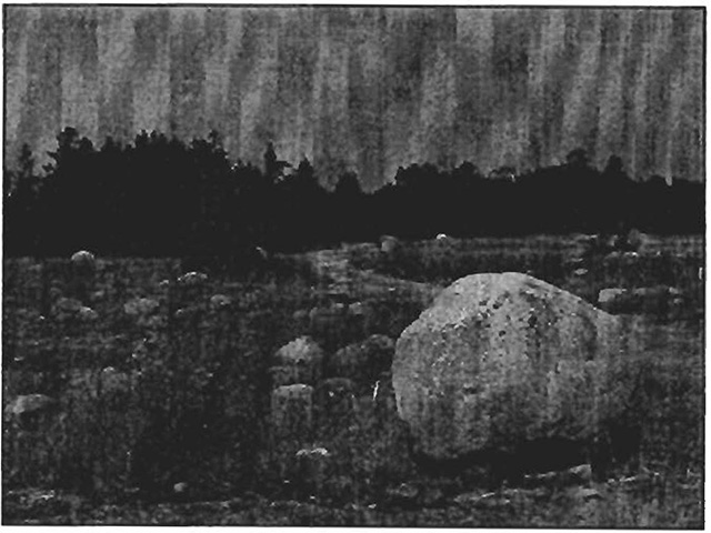
Figure 1: Mac’s Bay Conservation Reserve - bedrock pavement with glacial lakes shore boulders
4.3.1 Landforms
Mac’s Bay Conservation Reserve is almost all located below the high water mark of Proglacial Lake Nipissing. The bedrock underlying the site is Silurian dolostone of the Amabel formation. At the approximate location of this high water mark there is a ledge of dolostone approximately 1.2 metres high. It runs north-south for 100 metres near the eastern edge of the conservation reserve, and several large pieces of dolostone have separated from the ledge. (Jones, 2000)
To the west there is a large flat area of bedrock exposure which displays well developed clint and grike fissuring, these deep cracks have a roughly rectangular joint pattern widened by karstification since the most recent glaciation. The western boundary of this area boasts a small distinct escarpment approximately three metres high and two kilometers in length, and runs most of the length of the conservation reserve in a north south direction. The area becomes wooded on a substrate of moderate to shallow soils of the Rock Wendigo Complex, to the west and at a lower elevation. This consists of a mixture of rock outcrops and pockets of non-calcareous outwash sand occasionally overlain by very thin horizons of sandy loam. Noble (1995) describes these substrates as sandy till originating from ground moraine, and is typical of 40% of the Ecodistrict. Noble (1995) does not describe the area of Mac’s Bay Conservation Reserve and reports only one landform for the adjacent Misery Bay Provincial Nature Reserve. However Noble’s landform type, VIla-33M weakly broken bedrock plain, is also appropriate for Mac’s Bay Conservation Reserve. (Jones, 2000)
Mac’s Bay Creek flows into the Mac’s Bay from the northwest. This creek drains the lands of Misery Bay Provincial Nature Reserve north to Highway 540. The mouth of the creek is a small delta feature with standing water and mucky ground. At the present time there is considerable exposure of the deposit due to low water levels on Lake Huron. (Jones, 2000)
4.3.2 Vegetation communities
West of Murphy Point Access the forest cover is coniferous and dominated by white cedar. The eastern portion of the conservation reserve supports a young successional forest of white birch, poplar, white spruce and white cedar. Forest Resource Inventory (FRI) data from 1979 describes the area east of the road above the escarpment as barren and scattered, coniferous and white cedar dominated. The area is recovering into a woodland, consisting of poplar, white cedar, white pine and white spruce and is 45-75% tree cover at five to 8 metres tall. The escarpment which runs the length of Murphy Point Access supports a white cedar carbonate treed cliff community. The shady, moist community is in excellent condition and a rich diversity of non-vascular plant species. (Jones, 2000)
There are three types of alvar communities with Mac’s Bay Conservation Reserve. The Jack Pine-White Cedar-Common Juniper Treed Alvar Shrubland is disturbed probably due to past logging activities and the use of the area by white-tailed deer. The Creeping Juniper-Shrubby Cinquefoil Dwarf Shrub alvar community is found away from the shore and parallel to the road, it is a small and slightly disturbed community. The Fresh-Moist Tufted Hairgrass Open Alvar Meadow located at the shore is degraded but supports most typical species found in this community. (Jones, 2000)
Jones (2000) identified a preliminary species list of 193 vascular and 22 non-vascular plant species in Mac’s Bay Conservation Reserve.
4.4 Site history
The Life Science reports for the Manitoulin Coast and Uplands Study Area (Macdonald, 1980; Jones, 2000) provide background and important life science information that was used to prepare this document. Jones described that the original Ontario lands survey of the area in 1878 by C. Brockitt Abrey, which included the area regulated as Mac’s Bay Conservation Reserve, noted that the township had little land suitable for settlement, and that bush fires had burned over the southern portion of the township, extending across to the northerly side. There is ample evidence of this burning today within the conservation reserve, including charred stumps and debris. (Jones, 2000)
Originally referred to as Frechette Bay, it became known as Mac’s Bay at the tum of the century when a man named Mac McClellen ran a steam powered sawmill on the northeast side of the bay. Timber harvesting of red pine and white pine took place in the area on several occasions between 1930 and early 1960's. (Jones, 2000)
Lands now within the Mac’s Bay Conservation Reserve were acquired by the Nature Conservancy of Canada between 1978 and 1980. This land was then sold to the Province of Ontario in 1982, and regulated in 1997. Originally purchased to complement Misery Bay Provincial Nature Reserve, Mac’s Bay was deemed a conservation reserve due to non-conforming uses (i.e. mechanized travel) and will complement the conservation of core park values and ecological functions within Misery Bay Provincial Nature Reserve (OMNR, 1995).
4.5 Level of inventory
Table 2 indicates the current status of the inventory which has occurred for Mac’s Bay Conservation Reserve.
Table 2: Inventory and Survey Information for Mac’s Bay Conservation Reserve.
| Survey level | Earth / life | Cultural / recreational |
|---|---|---|
| Reconnaissance | 1980 Harvey | None |
| Resource Detailed | 1980 Macdonald 2000 Jones |
None |
5.0 State of the resource
The natural heritage of Ontario contributes to the economic, social and environmental well-being of the Province and its people. Protecting areas of natural heritage is therefore important for many reasons such as maintaining ecosystem health and providing habitat to maintain species diversity and genetic variability. Protected areas also provide scientific and educational benefits, they generate tourism, which bolsters local and regional economies, and they provide places where people can enjoy and appreciate Ontario’s natural diversity while enhancing their own health and well-being. In order to protect this vital natural heritage, Ontario established a provincial parks and protected areas system to identify and represent the entire suite of natural features and ecosystems within the Province. This representation and criteria to determine the current quality of that representation are discussed below (OMNR, 1997c).
Representation
Completing the system of parks and protected areas is based on the concept of representation; that is, capturing the full range of Ontario’s natural and cultural values. The goal of the Ontario parks and protected areas system is to protect the best examples of Ontario’s natural heritage including features, landscapes, and ecosystems at the ecodistrict level. The complete system must therefore protect a range of natural heritage values based on the geological and biological diversity of the Province (OMNR, 1997c). The best examples of representative features are considered to be provincially significant and may even be nationally or internationally significant. Locally and regionally significant areas also contribute to the system if they have been classified as the best representation currently available and have therefore been identified in some areas to meet the targets of representation in each ecodistrict.
The Mac’s Bay Conservation Reserve contributes to the life science representation of the protected areas system in Ontario. Mac’s Bay Conservation Reserve supports a two kilometre stretch of low escarpment, the longest found within protected areas in Ecodistrict 6E-17. Mac’s Bay Conservation Reserve contains three significant landform features, three provincially significant vegetation communities, four provincially significant plant species, and one regionally significant plant species. (Jones, 2000).
Quality of present representation
a) Diversity:
Diversity is a measure of the relative number of different landforms, or numbers of different vegetation and wildlife communities and species found in an area. The greater the number and variability of these features the more diverse the area. Mac’s Bay Conservation Reserve supports white cedar dominated coniferous forest, as well as a small stand of red pine between 110 and 120 years old there is no apparent red pine regeneration. The conservation reserve also supports three alvar communities in varying condition. There are rare plants documented within the conservation reserve including the fern Oregon Woodsia (Woodsia oregana ssp. cathcartiana) and Canadian St. John’s Wort (Hypericum canadense). Canadian St. John’s Wort has not been documented elsewhere on Manitoulin Island. (Jones, 2000)
b) Ecological factors:
The basic components that help define ecological factors include the size, shape and the ability of the site to maintain itself over time (Thompson, 1999). The ability of a site to buffer the core areas from adjacent land uses, its general location and location within the greater ecosystem will make the site more viable over time and help to contribute to overall ecosystem health. Generally, larger sites with more diversity are better than small, non-diverse areas; sites with a more rounded or naturally delineated shape are better than long, linear sites; and sites that are linked to or near to other protected areas are better than isolated protected areas.
Whenever possible, a site’s boundaries should be created to include the greatest diversity of life and earth science features to provide the maximum ecological integrity. It should be ecologically self-contained, bounded by natural features and include adequate area to protect the core ecosystems from surrounding land use activities (OMNR, 1992).
Mac’s Bay Conservation Reserve is a small site that is surrounded by numerous cultural values (e.g. Misery Bay Nature Reserve, and patent land). The Conservation Reserve boundary has not been surveyed. Until an official survey can be done, the guideline will be to have the Ministry of Natural Resources work with the local township of Burpee, the cooperating association for the Nature Reserve and the private land owners collaborate to establish the boundaries between the Reserve and private property in a manner that is agreeable to all parties. In the interim, the boundary can be located by an unofficial survey (e.g. compass line, GPS waypoints).
Future management of Mac’s Bay Conservation Reserve should take into consideration the core values being protected within the adjacent Misery Bay Provincial Nature Reserve
c) Condition:
Historically, Mac’s Bay Conservation Reserve has been disturbed by fire and evidence of this can be seen today within the site. Timber harvesting has taken place within Mac’s Bay Conservation Reserve from the 1930's through to the 1960's. Timber camps were once present in the area. In the Red Pine stand, evidence of a shack or stable is still visible. In the future, a management strategy may be required to encourage red pine regeneration. Several management aspects need to be studied before a strategy can be completed. These include the feasibility of management for red pine regeneration, the effect of the Murphy Point Access on the pine stand (especially if Murphy Point Access upgrading will be needed) and visitor and interpretive use of the pine stand.
d) Special features:
Mac’s Bay Conservation Reserve supports three alvar communities, the Red Pine stand, a low escarpment community and a delta feature which all have sensitive features that should be considered during future planning and management. Rare plants include the fern Oregon Woodsia (Woodsia oregana ssp. cathcartiana) and Canadian St. John’s Wort (Hypericum canadense). The site supports a white-tailed deer yarding area.
e) Current land use activities:
Several old trails exist within the conservation reserve. The northern portion of the Murphy Point Access is used in the winter season by a local snowmobile club (Manitoulin Snowdusters Association) as part of an island-wide snowmobile trail network. There are no existing authorized ATV trails within Mac’s Bay Conservation Reserve.
Summary:
The Mac’s Bay Conservation Reserve contributes to the life science representation of the protected areas system in Ontario. It contains significant landforms such as clint and grike fissured pavements, a low escarpment and stream delta. It supports provincially significant vegetation communities, plants, and birds (Jones, 2000).
The site shows some signs of natural disturbance and human disturbance. The natural heritage features are not adversely affected by current permitted uses. However, additional disturbance due to future increases in use(s) and/or development could impact on the quality of the present representation within Mac’s Bay Conservation Reserve. Additional measures to protect these natural heritage features should be considered during future planning.
5.1 Social/economic interest in the area
This section will address the contribution of the Mac’s Bay Conservation Reserve to the local economy and society through the opportunities it represents.
a) Linkage to local communities:
Misery Bay Nature Reserve, Mac’s Bay, and patent land surround Mac’s Bay Conservation Reserve. The conservation reserve is accessed via the Murphy Point Access from Highway 540. Alternative access from the west, through Burpee 5th line and the Little Lake Huron Road provides access to Miser Bay Provincial Nature Reserve. Murphy Point Access is currently used by patent landowners to access their property at Murphy Point, as well as by a local commercial fisherman to access Lake Huron. Murphy Point Access and the existing trails within the conservation reserve are currently used by both snowmobiles, ATVs and by others seeking recreation in the area - e.g. camping, walking, wildlife viewing.
Currently there is no trapping or hunting of large game within the conservation reserve. Hunting may be considered in the future, subject to a Test of Compatibility and public consultation, to ensure that the values within the conservation reserve are not negatively impacted by this activity, and then only through a lottery system established by the Ministry of Natural Resources. Mac’s Bay Conservation Reserve supports other recreational activities such as hiking, bird watching, wildlife viewing, and photography etc.
b) Heritage estate contribution:
The Mac’s Bay Conservation Reserve contributes to the Province’s parks and protected areas system through its regulation, representation and the long-term management that will sustain natural heritage values.
The protected area system allows for permanent protection of Ontario’s natural heritage features, and it will provide valuable areas as benchmarks to scientists and educators, as more of Ontario’s land base is developed or altered from its natural state. Each protected area contributes to this heritage in its own unique way - whether it is a contribution to the representation of an earth or life science value, a recreational or economic opportunity, or through its cultural or historical significance. The designation of an area as a conservation reserve helps define its role in the system.
The Mac’s Bay Conservation Reserve’s distinct contribution is a combination of life and earth science heritage protection, and educational and recreational opportunities.
c) First Nations:
The protection of Mac’s Bay Conservation Reserve and the Statement of Conservation Interest are not meant to infringe on the Aboriginal Rights and treaty rights of any First Nation in any way.
d) Mining interests:
Mac’s Bay Conservation Reserve contains no mining tenure. Mining and surface rights have been withdrawn from staking within the conservation reserve boundaries under the Mining Act (RSO 1990 Chapter M.14). Mining will not occur in any regulated protected area.
e) Forest and fire management history:
The conservation reserve has historically been disturbed by fire, evidence of burning including charred stumps and debris can still be seen today. Timber harvesting has occurred within the conservation reserve several times in the past including between 1930 and the 1950's, and most recently in the 1960's. (Jones, 2000) This area is excluded from future commercial timber harvesting.
f) Other government agencies, departments or crown corporations:
Other Government Agencies that may have an interest in the site include the Ministry of Culture (MOC), the Ministry of Tourism and Recreation (MTR), the Ministry of Transportation (MTO), and the Ministry of Municipal Affairs and Housing (MMAH). Although there are no known cultural heritage values present at this time, if values were identified in the site the MNR would work with the MOC to ensure proper protection of any cultural heritage resources.
The MNR will also work in conjunction with the MTR to identify/enhance any compatible tourism opportunities, in particular where Resource-Based Tourism potential is identified. Proper evaluation will be undertaken where opportunities are identified to ensure consistency with the management policies of this conservation reserve.
At this time no highways are planned in, or adjacent to, this conservation reserve. However, in the future if a highway is planned in the vicinity of this conservation reserve, the MNR and MTO would work together to ensure that construction would not occur within the boundaries of this protected area, and that uses adjacent to the conservation reserve would have regard for the values being protected.
The MNR would also work in conjunction with the MMAH should there be any proposed development adjacent to Mac’s Bay Conservation Reserve. The MMAH needs to be aware of the location of this site in order to comment on proposed cottage lot development. Proper protection of values within the site would be given due regard should development occur in the immediate area.
g) Non-Government organizations and other industry interests:
Non-Government organizations may express an interest in the Mac’s Bay Conservation Reserve (e.g. Partnership for Public Lands, the Federation of Ontario Naturalists, Northern Ontario Tourist Outfitters, the Ontario Federation of Anglers and Hunters and the Nature Conservancy of Canada).
The existence of this protected area may provide enhanced recreation potential and associations and/or organizations may wish to approach the MNR as collaborating stewards of the protected area. The MNR may work in conjunction with any association and/or organization that identifies an interest or a compatible use potential within the site.
Other industries or companies that may have an interest in the Mac’s Bay Conservation Reserve may include the Ontario Prospector’s Association, and the Aggregate Producer’s Association. The interests of these associations may be limited to recognizing the boundaries and values protected in order to uphold the MNR's management policies within the conservation reserve. No new exploration or mining will be permitted within the boundaries of Mac’s Bay Conservation Reserve.
The Friends of Misery Bay (FOMB) is an incorporated, non-profit charity with a mandate to support planning, management and operation of Misery Bay Provincial Nature Reserve. As the Nature Reserve is adjacent to Mac’s Bay Conservation Reserve and the land use in the latter may affect Misery Bay, FOMB may work with MNR to further the protection, research and education in the conservation reserve. The FOMB assisted with the preparation of this Statement of Conservation Interest. Members of this group are aware of the values within Mac’s Bay Conservation Reserve and have been supportive from the beginning in the creation of the Conservation Reserve. FOMB support Ontario Parks and MNR in the management of Misery Bay Provincial Nature Reserve and will support MNR in the management of the Conservation Reserve. FOMB has found funding to implement management plan policies for Misery Bay Provincial Nature Reserve and may play a role in managing the operations of the conservation reserve according to the policies in this SCI.
5.2 Fisheries and wildlife
The waters of Mac’s Bay are not included within the conservation reserve. However, the Life Science Report for Manitoulin Coast and Uplands Study Area (Jones, 2000) includes the following observations; the bay appears to be a very productive habitat and supports sandpipers and flocks of small ducks (teals, and mallards). The bay is a spawning and nursery habitat for Northern pike and is known locally as a good place to catch pike (Jones, 2000).
During the Life Science Report inventory Jones reported evidence of beaver, black bear, mink, otter, porcupine, red squirrel, snowshoe hare, and white-tailed deer. Historically there is evidence the area has been used for small game and white-tailed deer hunting. The conservation reserve is considered a white tailed deer yarding area, a distinct browse line can be seen, and the openings of treed alvar above the low escarpment show heavy winter use. (Jones, 2000)
Mac’s Bay Conservation Reserve supports the nesting or migration of many bird species, including species which are regionally or provincially significant, and three species which are endangered. (Jones, 2000)
5.3 Natural heritage stewardship
The Mac’s Bay Conservation Reserve contains three significant landforms, three provincially significant vegetation communities, four provincially significant plant species, and one regionally significant plant species (Jones, 2000). The conservation reserve also contributes to the variety of recreational opportunities that can be found in the parks and protected areas system. At the present time there are no monitoring or research programs in place within Mac’s Bay Conservation Reserve.
5.4 Cultural heritage stewardship
There are no known cultural heritage values within the Mac’s Bay Conservation Reserve, and no detailed research has been conducted as of this date to document possible cultural heritage values. However, the possibility of heritage values being present does exist. If archaeological or cultural resources are discovered within the conservation reserve, proposals pertaining to the development and use of these cultural resources may be screened through direction provided in "Conserving a Future For Our Past: Archaeology, Land Use Planning & Development In Ontario" (MCzCR, 1997). If in the future cultural heritage values are identified within the site, the MNR will work with the Ministry of Culture to ensure proper protection of these cultural heritage resources.
5.5 Land use/current or past development
There is no mining tenure within the site and no mines have been developed on the site in the past. There are no patent lands nested within the site and there are no other forms of tenure such as land use permits or licenses of occupation. Small aggregate sources were used in the past within the area before it became a protected area. Aggregate will not be extracted within the regulated conservation reserve boundary.
5.6 Commercial use
There are no commercial uses of Mac’s Bay Conservation Reserve at this time. A commercial fisherman uses the Murphy Point Access to access his boat dock on the east side of Murphy Point on Lake Huron.
5.7 Tourism/ recreational use/opportunities
Current recreational uses and opportunities of the site include ATV and snowmobile use on the existing trails and Murphy Point Access, as well as hiking, bird watching etc. Winter activities such as skiing and snowshoeing are also recreational uses. Further detailed recreation inventory studies need to be undertaken to confirm the existence of current and potential recreational uses.
5.8 Client services
Currently, client services are being provided at the Sudbury District and Espanola Area MNR offices in the form of knowledgeable staff and available site maps. Further client services may be developed as a result of this plan, please see section 6.2 State of the Resource Management Strategies.
6.0 Management guidelines
6.1 Management planning strategies
Commitments identified in the current policy for conservation reserves (Policy 3.03.05 PLA) will form the basis for land use within Mac’s Bay Conservation Reserve. Management strategies for these uses must consider the short and long-term objectives for the reserve. For up to date information on permitted uses refer to the Crown Land Use Policy Atlas - Mac’s Bay Conservation Reserve Policy Report.
Protected areas will be managed to retain and/or restore natural features, processes and systems. They will also provide opportunities for compatible research, education and outdoor recreation activities (MNR, 1997c). Proposed uses and development will be reviewed on a case-by-case basis. A Test of Compatibility, (Procedural Guidelines B - Land Uses PL 3.03.05) must be passed before they are deemed acceptable. The emphasis will be on ensuring that the natural values of the conservation reserve are not negatively affected by current and future activities. Therefore any application for new specific uses will be carefully studied and reviewed via the above environmental screening process, as well as any other MNR environmental screening process.
Management strategies will also be consistent with the objectives of increasing public awareness, promoting responsible stewardship, providing marketing opportunities, and identifying inventory, monitoring, assessment, reporting and research potential.
6.2 "State of the resource" management strategies
The development of this SCI and the long-term management and protection of the site will be under the direction of the MNR's Espanola Area Supervisor. The following section will deal with the management strategies that are specifically laid out to maintain, protect and enhance the existing natural heritage values and land use activities of the Mac’s Bay Conservation Reserve.
Natural Values
The management intent for the Mac’s Bay Conservation Reserve will allow for natural ecosystems, processes and features to operate undisturbed with minimal human interference while providing compatible educational, research and recreational activities. Forest ecosystem renewal will only be entertained via a separate vegetative management plan.
The MNR recognizes fire as an essential process fundamental to the ecological integrity of conservation reserves. In accordance with existing Conservation Reserve Policy and the Forest Fire Management Strategy for Ontario, forest fire protection will be carried out as on surrounding lands.
Whenever feasible, the MNR fire program will endeavor to use "light on the land" techniques, which do not unduly disturb the landscape, in this conservation reserve. Examples of "light on the land" techniques may include limiting the use of heavy equipment or limiting the number of trees felled during fire response efforts.
Opportunities for prescribed burning to achieve ecological or resource management objectives may be considered. These management objectives will be developed with public consultation prior to any prescribed burning and reflected in the document that provides management direction for this conservation reserve. Plans for any prescribed burning will be developed in accordance with the MNR Prescribed Burn Planning Manual, and the Class Environmental Assessment for Provincial Parks and Conservation Reserves (approval pending).
Defining compatible uses, enforcing regulations, monitoring and mitigating issues will protect all earth and life science features. Industrial activities such as commercial timber harvest and new hydro generation will not be permitted within the conservation reserve. Extraction of unconsolidated sand, gravel, soils or peat is not permitted. Energy transmission, communication and transportation corridors or construction of facilities are discouraged within the boundaries of the conservation reserve. Such structures negatively impact on the quality of representative features that require protection. Alternatives should be reviewed via larger landscape planning processes. There is no current access to Murphy Point for Ontario Hydro lines nor has there been a proposal to provide power to the cottages at Murphy Point. An existing buried telephone cable extends from Highway 540 to the Murphy Point seasonal cottages. In some locations the telephone cable is at-surface generally following the un-surveyed Murphy Point Access from Highway 540 to the cottages at Murphy Point. New roads for resources extraction and/or private use will generally not be permitted (OMNR, 1999). Other activities that do not pass a Test of Compatibility will be prohibited (OMNR, 1997a).
The deliberate introduction of exotic and/or invasive species will not be permitted. Management activities will strive to reduce the chance of unintentional exotic introductions. Programs may be developed to control forest insects and diseases where there is a concern that significant values may be compromised. Remedies must focus on the outbreak or infestation. Native biological or non-intrusive solutions should be applied whenever possible.
The collection/removal of vegetation and parts thereof may be permitted subject to a Test of Compatibility, MNR's Espanola Area Supervisor may authorize such activities for the purposes of food harvesting, removing exotic species, rehabilitating degraded sites within the reserve, collecting seeds for maintaining genetic stock and/or for inventory or research. The cutting of trees for non-commercial purposes (e.g. fuel wood) is not permitted.
MNR will provide leadership and direction for maintaining the integrity of this site as a heritage estate. To ensure MNR protection objectives are being fully met within the conservation reserve, activities on the surrounding landscape should consider the site’s objectives, heritage values and the design flaws currently present. MNR via input and plan review will ensure the conservation reserve’s values are considered in local and adjacent land use strategies and plans. Research, education and interpretation will be encouraged to provide a better understanding of the management and protection of the natural heritage values and will be fostered through local and regional natural heritage programs, initiatives and partnerships. Furthermore, adequate protection of core values will require cooperation with adjacent land users.
Cultural heritage values
It is not known if cultural heritage values exist within the Mac’s Bay Conservation Reserve, however, if values are confirmed management would be consistent with Conserving a Future For Our Past: Archaeology, Land Use Planning & Development In Ontario (MCzCR, 1997). MNR would work with the Ministry of Culture, should any cultural or archaeological values be discovered within the site to ensure adequate protection. Research and studies should be conducted to determine the potential and/or existence of cultural or archaeological resources.
Land use/ past and existing development
The sale of lands within the conservation reserve is not permitted as per Conservation Reserve Policy (PL 3.03.05). No new recreational camps will be permitted. Road realignments, telecommunications and other resource networks will be discouraged from crossing the site and interrupting the conservation reserve’s natural state. New roads for resource extraction and/or private use will generally not be permitted, nor will additions to existing roads or up-grading of existing roads be permitted.
Through the ministry’s plan input and review program, applications for more intense use will be reviewed to ensure natural heritage values within the conservation reserve are considered and protected in planning decisions on adjacent private land.
Any new developments (e.g. tourism developments) proposed for the conservation reserve must go through a Test of Compatibility to ensure that the activity is permitted and to ensure the natural heritage values within the site are protected. If a proposal is considered, public consultation may be required. If accepted, an amendment of the SCI would be required.
Social/economic interest
The economic contribution of the Mac’s Bay Conservation Reserve to the local community could be harnessed through marketing strategies that may maintain existing tourism in the area, while allowing the nearby towns and tourist operators to benefit through money spent at the local businesses. Socially, this area provides a recreational reserve for local people to enjoy for their own health and wellbeing. The people of Ontario generally benefit either through direct enjoyment of the area or through the knowledge that a piece of our life science and glacial history has been preserved. Other interest groups such as colleges and universities can benefit from this reserve as a place to study several natural features and processes and the local parks, towns and tourist outfitters would benefit economically through the presence of researchers.
Fisheries and wildlife
Wildlife resources will continue to be managed in accordance with specific policies and regulations defined by the Ontario Ministry of Natural Resources under the Fish and Wildlife Conservation Act, and the Espanola Area Supervisor. Management of these resources will have consideration for the earth and life science features contained within the site. White-tailed deer hunting does not currently take place within Mac’s Bay Conservation Reserve. However, hunting may be permitted in the future subject to a Test of Compatibility and would require a lottery system which may be established and implemented by the Espanola Area Supervisor, provided it is shown that this activity would not negatively impact the values being protected within the conservation reserve.
Wildlife viewing activities may be enhanced via client services with the existing trail networks supporting this activity. New trail development, and linkages to Misery Bay Provincial Nature Reserve may be entertained for this activity providing a Test of Compatibility is conducted and passed.
Commercial activities
At this time there are no commercial operations within Mac’s Bay Conservation Reserve. A commercial fisherman uses Murphy Point Access to access his boat dock on the east side of Murphy Point on Lake Huron.
New commercial activities may be permitted and are subject to a Test of Compatibility which would determine the impact of said activity to the conservation reserve values.
Tourism and recreation
The earth and life science features, and their protection, shall be the overall theme for tourism and recreation within the conservation reserve. There are no existing tourism facilities located in or directly adjacent to this conservation reserve. Any proposed tourism infrastructure or facilities would be required to undergo a Test of Compatibility and if accepted, further planning would occur requiring public consultation and an amendment to this document. The existing local tourist outfitters can continue accessing this reserve as they have in the past, however, MNR will work with the proponents to ensure the values of the conservation reserve are respected and maintained to the highest level possible (see previous Commercial Activities Strategies).
Most recreational activities that have traditionally been enjoyed in the area can continue, provided they pose little or no threat to the natural ecosystems and features protected by the conservation reserve. Current activities include bird watching, hiking, skiing. ATV use and snowmobiling. Camping is a current use of the conservation reserve and will be permitted to continue.
Snowmobiles and All-Terrain Vehicles (ATV's) are permitted on existing trails including Murphy Point Access, all mechanized travel is restricted to existing trails. To protect the natural heritage features within the conservation reserve, MNR will seek direction from local communities on how to reduce off trail use, if such activities become problematic.
Client services
Clients indicating their interest in the management, planning and future use in the conservation reserve will be put on a mailing list and notified of any future planning initiatives for the site.
Client services will be provided at the Sudbury District office and at nearby provincial parks through interpretive pamphlets and knowledgeable staff. In the future, information may be delivered from different sources; however, the MNR Sudbury District office will be the lead agency for responding to inquiries regarding access, permitted and restricted activities, values and recreation opportunities. A management agreement may be pursued with an appropriate partner to share responsibilities for information services and the delivery of other aspects of this SCI. For example having the interpretive pamphlets available at local convenience stores and other appropriate businesses could provide additional client services venues.
It is further recommended that visitors and conservation reserve users and the local population be informed of the significance and sensitivity of the site via fact sheets, community visits and other educational or interpretive programs.
Aboriginal interests
Traditional activities and aboriginal rights will not be affected within the boundaries of this conservation reserve. First Nation communities are encouraged to continue to use these areas as they have in the past.
6.3 Promoting inventory, monitoring, assessment, reporting and research
Scientific research by qualified individuals or institutions, which contributes to the knowledge of natural and cultural history and to environmental and recreational management,. will be encouraged. Requests or applications to conduct research will be reviewed by the Sudbury District MNR office to ensure that the studies are non-invasive and that no values will be damaged in the process. Research programs will be subject to ministry policies and other legislation.
Approved research activities and facilities will be compatible with the protection objectives. Any inventory, monitoring, assessment, reporting or research developments or facilities will not be considered until a Test of Compatibility is conducted and the proposal is approved by the Espanola Area Supervisor. The Test of Compatibility or environmental screening process could include a review of the demand for structures or activities and may require more detailed life or earth science or cultural information and possibly more detailed planning. Inventory, monitoring, assessment, reporting and/or research will be consistent with provincial and regional protocols and strategies. Permanent plots or observation stations may be established so researchers can monitor features and values over time. The Espanola Area Supervisor may approve the removal of any natural or cultural specimen by qualified researchers. Any materials removed will remain the property of the Ministry of Natural Resources. Any site that is disturbed will be rehabilitated as closely as possible to its original state. The Espanola Area Supervisor may apply additional conditions.
Encouraged research may focus on the interrelationship with other nearby protected areas, such as Misery Bay Provincial Nature Reserve. In particular, research may focus on the effectiveness of isolated protected areas and how these areas need to be of a minimum size and shape and be connected through supportive landscape management in order to maintain ecosystem health and diversity. Also the effects of straight or fragmented boundaries versus naturally delineated boundaries could be studied in the Mac’s Bay Conservation Reserve location. Further research and monitoring requirements may be determined through forthcoming regional and provincial strategies.
Further inventories may be required for life science evaluation, earth science evaluation and recreation use and potential. This research should be conducted at the earliest opportunity. Verified findings should be incorporated into this SCI through the amendment process. Inventory which is completed as a requirement for this research should be appended to the updated SCI upon completion.
Other specific research projects that could be undertaken may include; the effects of human disturbance on the site, determination of the existence of any rare, vulnerable or threatened species, and/or vegetation community dynamics.
6.4 Implementation and plan review
The Mac’s Bay Statement of Conservation Interest will be reviewed on an ongoing basis and as required. Implementation of the SCI and management of the reserve are the responsibility of the Espanola Area Supervisor. Partnerships may be pursued to address management needs.
Adaptive management strategies will be used in the event of new information that has a significant effect on the current Statement of Conservation Interest. If changes in management direction are needed at any time, the significance of the changes will be evaluated. Minor changes that do not alter the overall protection objectives may be considered and approved by the District Manager without further public consultation and the plan will be amended accordingly. In assessing major changes, the need for a more detailed Resource Management Plan will first be considered. Where a RMP is not considered necessary or feasible, a major amendment may be considered with public consultation. The Regional Director will approve major amendments.
6.5 Marketing
The Mac’s Bay Conservation Reserve could be marketed in future in conjunction with the adjacent Misery Bay Provincial Nature Reserve. Factsheets may be prepared to inform the public about these values which will be available at the Sudbury District MNR office, the Espanola Area Office, local provincial parks as well as possibly at the tourist outfitters. Marketing efforts to increase use are not a priority.
7.0 References
Jones, J. 2000. Life Science Report Manitoulin Coast and Uplands Study Area. Blue Jay Creek Provincial Park, Mac’s Bay conservation Reserve, Misery Bay Provincial Nature Reserve, Queen Elizabeth Queen Mother M'Nidoo M'Nissing ("Spirit Island") Proposed Provincial Park. 157 pp. Appendices, Maps.
Ministry of Citizenship, Culture and Recreation. 1997. Conserving a Future for out Past: Archaeology, Land Use Planning and Development in Ontario. Revised 1998. Ontario Archaeological Society, Inc. 43 p.
Macdonald, I. 1980. Life Science Report for Misery Bay, Prepared for OMNR, Northeast Region, Sudbury.
Nobel, T.W., 1995. Site District 5E2. Gap Analysis, Draft. OMNR, Central Region. Huntsville, Ontario.
Ontario Ministry of Natural Resources. 1992. Ontario Provincial Parks Planning and Management Policies, 1992 update. Queens Park, Toronto, ON. 90 pp. plus appendices.
Ontario Ministry of Natural Resources. 1995. Misery Bay Provincial Nature Reserve Management Plan. 15 pp.
Ontario Ministry of Natural Resources. 1997a. Conservation Reserves, Policy PL 3.03.05. 8 p.
Ontario Ministry of Natural Resources. 1997b. Conservation Reserves, Procedure PL 3.03.05. 22 p.
Ontario Ministry of Natural Resources. 1997c. Nature’s Best. Ontario’s Parks and Protected Areas: The Framework and Action Plan. 37 p.
Ontario Ministry of Natural Resources. 1,999. Ontario’s Living Legacy Land Use Strategy. 136 p.
Thompson, J.E. 1999. Cheatsheet "Building the System". Ontario Ministry of Natural Resources.
8.0 Map: Mac’s Bay Conservation Reserve
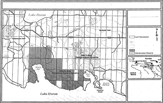
Enlarge Map: Mac’s Bay Conservation Reserve
9.0 Appendices
Appendix A: Mac’s Bay Conservation Reserve: Permitted Uses Table for Conservation Reserve
Permitted Uses Table for Conservation Reserves
As per Policy (PL 3.03.05)
Recreation
| Activity | Permitted | Policy Clarification |
|---|---|---|
| Sport Fishing | N/A | Waters of Mac’s Bay are not in the reserve. |
| Sport Hunting* | Yes* | Existing and new uses permitted |
| Food Gathering | Yes | Existing and new uses are permitted |
| Picnicking | Yes | |
| Facility Infrastructure | Maybe | Existing facilities/use may be permitted. New facilities may be considered. |
| Snowmobiling - Existing | Yes | Existing use on authorized trails may continue. |
| Snowmobiling - New | Maybe | New trails may be permitted. |
| Non-trail snowmobiling | Maybe | Use may be permitted for the direct retrieval of game only |
| ATV Use - Existing | Yes | Existing use on authorized trails may continue. |
| ATV Use - New | Maybe | New trails may be permitted. |
| Non-trail ATV use | Maybe | Use may be permitted for the direct retrieval of game only |
| Motorized Boating | N/A | Waters of Mac’s Bay are not in the reserve. |
| Canoeing/Kayaking | N/A | Waters of Mac’s Bay are not in the reserve. |
| Climbing | Maybe | May be permitted if does not affect values. |
| Camping | Maybe | Use may be permitted |
| Trails - Hiking: Existing | Yes | Existing authorized trails can continue there are significant demonstrated conflicts. |
| Trails - Hiking: New | Maybe | |
| Trails - Cross-country Skiing: Existing | Yes | New trails may be considered through planning. |
| Trails - Cross-country Skiing: New | Maybe | |
| Trails - Horse Riding: Existing | Yes | |
| Trails - Horse Riding: New | Maybe | |
| Trails - Cycling: Existing | Yes | |
| Trails - Cycling: New | Maybe |
*White-tailed deer hunting does not currently take place within Mac’s Bay Conservation Reserve. However, hunting may be permitted in the future subject to a Test of Compatibility and would require a lottery system which may be established and implemented by the Espanola Area Supervisor, provided it is shown that this activity would not negatively impact the values being protected within the conservation reserve.
Commercial activities
| Activity | Permitted | Policy Clarification |
|---|---|---|
| Commercial Fishing | N/A | Waters of Mac’s Bay are not in the reserve. |
| Bait Fish Harvesting | N/A | Waters of Mac’s Bay are not in the reserve. |
| Commercial Fur Trapping - Existing | Yes | Existing use permitted to continue. Transfer requests will be considered in the context of the SCI/RMP. |
| Commercial Fur Trapping - New | Maybe | New traplines may be permitted. |
| Trap Cabins - Existing | N/A | Existing use permitted to continue. |
| Trap Cabins - New | No | No new cabins permitted. |
| Private Recreation Camps: Existing | Yes | Existing camps permitted to continue. |
| Private Recreation Camps: New | No | New camps will not be permitted. |
| Outpost Camps / Tourism Facilities: Existing | Yes | Existing outpost camps permitted to continue. Transfer requests will be considered in the context of an SCI/RMP. |
| Outpost Camps / Tourism Facilities: New | No | New outpost camp not permitted. |
| Commercial Bear Hunting: Existing | Yes | Existing use permitted to continue. Transfer requests will be considered in the context of the SCI/RMP |
| Commercial Bear Hunting: New | No | New operations not permitted. |
| Wild Rice Harvesting: Existing | Yes | Existing use permitted to continue. |
| Wild Rice Harvesting: New | Maybe | New operations may be permitted to continue. |
| Food Harvesting | Maybe | Existing use may be permitted to continue. New operations can be considered. |
Industrial activities
| Activity | Permitted | Policy Clarification |
|---|---|---|
| Timber Harvesting | No | |
| Cutting of trees by leaseholders, cottagers, and other property owners for fuelwood and other small scale uses (no explicit policy) | Maybe | May be authorized by permit subject to a review and determination of the impact on natural heritage values. Intended only for those who do not have road access to their property. Intended uses include fuelwood, dock stringers, and other occasional small-scale uses. |
| Mineral Exploration | No | |
| Mining | No | |
| Extraction of aggregate, peat, soil, and other materials. | No | |
| Hydro Power Generation | No | |
| Communication Corridors: Existing | Yes | Existing use permitted to continue |
| Communication Corridors: New | No | New corridors to be discouraged through planning |
| Energy Transmission Corridors: Existing | Yes | Existing use permitted to continue |
| Energy Transmission Corridors: New | No | New corridors to be discouraged through planning |
| Transportation Corridors: Existing | Yes | Existing use permitted to continue |
| Transportation Corridors: New | No | New corridors to be discouraged through planning |
Resourse management
| Activity | Permitted | Policy Clarification |
|---|---|---|
| Resource Inventory | Yes | |
| Resource Monitoring | Yes | |
| Fire Protection | Forest fire protection will be carried out in accordance with approved Fire Management Strategies unless alternative direction for fire suppression or fire management is approved through an SCI/RMP | |
| Insect and Disease | Maybe | Control of insects and diseases addressed on a site basis. |
| Featured Species Management | Maybe | Existing and new featured species management may be permitted. |
Other Activities
| Activity | Permitted | Policy Clarification |
|---|---|---|
| Research | Yes | Research will be encouraged to provide a better understanding of the natural values protected by a conservation reserve and to advance their protection, planning and management. With MNR permit only. |
| Collecting | No | |
| Land Disposition | No | |
| Habitat Management for Wildlife (no explicit policy) | Maybe | Specific management prescriptions will be identified in SCIs and RMPs. No new habitat management will be permitted until an SCI or RMP is prepared. Existing habitat management practices will be reviewed to ensure that they are consistent with the protection of identified natural heritage values. |
| Photography and Painting | Yes | |
| Wildlife Viewing | Yes | |
| Outdoor Education | Yes |
Appendix B: SCI Test of Compatibility
From the SCI Test of Compatibility NER Guideline in Planning process for Conservation Reserves Statement of Conservation Interest (SCI) and Resource Management Plans (RMP) Northeast Region Guidelines Version 2.1 September 17. 2001 Appendix 4, page 44.
Test of Compatibility:
-
Conformity to SCI - This is not applicable to evaluating current or new uses that come forward during the SCI planning process. However, the SCI should include a statement that speaks to the required screening of any future use or uses that are not covered in the current SCI.
-
Screening Process - proposed uses for the area must be assessed before they are approved. To establish a minimum standard, NER recommends that the Screening Process identified in Section 4.2 of A Class EA for Provincial Parks and Conservation Reserves Phase IIb: Draft Class EA (subject to approval by MOE) be used to screen projects and options.
The Screening Criteria from the draft Class EA (Table 4.1) is further detailed below within the context of SCI planning.
-
Impact Assessment- the Test of Compatibility from the Conservation Reserve Policy PL 3.03.05 identifies the classes of values and main concepts that need to be considered in determining the impacts of uses on a specific Conservation Reserve. These include:
- Natural heritage
- Cultural
- Research activities
- Current uses
- Area administration
- Accommodating the use outside the CR
- Socio-economics
- Area accessibility
The Class EA (Table 4.1) presents similar values and concepts under the following considerations
- Natural environment
- Land use, resource management
- Social, cultural and economic
- Aboriginal
The above considerations and classes of values are meant to assist planning staff in answering the following questions for any potential use:
- Will the new use impact any values within the Conservation Reserve?
- If so how?
- To what degree?
- Is it tolerable?
The new screening process and associated criteria identified in Table 4.1 of the draft Class EA gives planning staff more direction than the Conservation Reserve Policy 3.03.05. However this section attempts to assist planning staff by providing some direction for further interpreting the criteria to complete a Test of Compatibility for uses within a Conservation Reserve.
The following information for each Conservation Reserve is available and can be used to assess the required criteria:
- Background information and current inventory data
- Current inventory evaluations (e.g. earth, life and recreational check-sheets)
- Future ongoing analysis on the site
Interpretation of background information & current inventory data:
Background information files, summaries and other data can be beneficial in determining additional criteria that could be added to or address criteria already mentioned in the EA screening process. Criteria that are linked to habitat needs or specific life or earth science features are often first record during a District’s initial review of a site. Databases such as NRVIS or documents such as Lake Survey files, Site District Reports or Forest Management Plans can identify the location of values and sometimes determine a value’s significance or sensitivities.
Current inventory evaluations:
The most current state of the resource for a specific Conservation Reserve will be the earth, life and recreational check-sheet. These documents determine the current earth and life science values, their present state and their significance. The recreational check-sheets determine current recreational features and current and potential recreational activities and feature significance and sensitivity to present and future uses.
For earth and life science check-sheets, five (5) major sections are completed that include; representation and the quality of the representation (e.g. based on condition, diversity and ecological considerations) and special features. These five categories are reflected within the screening criteria presented in draft Class EA document or could be used to develop additional criteria. Some thoughts concerning the five categories are further discussed below.
Representation:
Representation within inventoried sites contains the type, number, location and shape of the community based values within the Conservation Reserve. For example the number of different forest cover types, wetland and freshwater communities, earth science features or recreational features defined in recreational check-sheets. The survey determines if the values are totally within the site or if the value straddles the site’s boundary? This section and the significance section of the check-sheet can help you define significant earth or life science features, important wildlife habitat, or record the location and extent of old growth within a site or other features. Representation determines not only specific communities or special features but also establishes the core protected areas within the Conservation Reserve, which is a value that has to be protected as well. Finally, any list of screening criteria should mention the affect a potential permitted use may have on the quality of the representation present within the site. The quality of the site’s representation is mentioned in the following three categories below.
Condition:
Condition is the level of natural and human disturbance that the site has experienced to date. The major natural disturbances in Northeast Region include; burned, blown down, flooded or insect effected stands or areas. Human disturbances could include; clear-cut areas, mining related sites, drainage areas, ditches or pits, utility corridors, railways, roads, hiking or ATV trails, assess points, dams, cottages or other facilities on site. Such actions or structures can affect the site negatively by influencing specific special features (e.g. nest sites or wildlife travel corridors) or severing significant communities or the Conservation Reserve’s core protected areas. This section could help interpret the following screening criteria; affect on water quality, specific species or habitat needs or criteria that speak to undisturbed core protected areas. Such core protected areas criteria could include for example - effect a permitted use or potential use has on natural vegetation and habitat through fragmentation or how use could affect easily eroded or sensitive wind-blown deposits?
Diversity:
This is a measure of the site’s life and earth science heterogeneity. For earth and life sciences the evaluation is based on the number and variety of natural landscape features and landforms for earth science values and the relative richness and evenness of a site’s life science components. For our life science check-sheet inventory we determine richness by counting the number of vegetative cover types present within a site and evenness as the proportion of each cover type represented within a site. So a site that has many cover types of roughly the same size is more diverse than a site with few cover types or where a site has the same number of cover types but has reduced evenness (e.g. one cover type dominates with the other cover types present but with little area devoted to them). Criteria that speak to all aspects of diversity should be part of any screening process.
Ecological considerations:
This is where we discuss the design of the site, its strengths and weaknesses and potential problems that may arise during planning. Ecological considerations include; size, shape, buffering capacity from adjacent land use activities, watershed location and linkage to the larger landscape. Generally speaking the following are some rules of thumb;
- Larger sites are preferred over smaller sites because of their greater potential for ecological diversity and stability
- Rounder sites are better than elongated sites for they have more intact core and can buffer adjacent land use activities better than elongated sites
- Sites that contain headwaters have more control over environmental inputs than sites located downstream
- Biological boundaries that are linked to larger undisturbed lands are better than cultural boundaries such as roads or railway lines that sever the site from its larger landscape for long periods of Cultural boundaries are preferred over vector boundaries that can divide or fragment core protected areas
So by looking at the size, shape and location of a site with respect to its larger environment, planners may be able to address specific screening criteria. Such screening criteria could include; effect on water quality or quantity, effect on fish and wildlife habitat and linkages, effect on drainage, sedimentation and erosion, potential long term planning problems because a site is very small in size or linear in shape, etc.
Special features:
Of all the data that is collected within a site, the special features section may be the most easily understood values. Generally landscape and habitat values are mentioned under the representation section of the check-sheet with specific values such as; Old Growth, Species at Risk (SAR), colonial birds, moose aquatic feeding areas, raptor nests, etc. are presented within this section. Data are available from FMP's or NRVIS databases as well as fish and wildlife files and reports and know recreation values available from District staff. The Class EA screening criteria contains a number of these values.
Note: Within the check-sheets be sure to review the significance level, recommendations and associated documentation listed with any particular check-sheet. For more information on check-sheet development see J.E. Thompson, 2001. Life science check-sheets information template. OMNR internal report. 6 pp.
Future ongoing analysis on the site:
If during planning specific information is not available to complete impact assessment analysis, then SCI's should not be the information gap and document the need to collect the required information in the future. In addition, future inventory, monitoring, assessment and research within the Conservation Reserve may also help planners and managers deal with future uses and impact assessments.
Appendix C: Statement of Conservation Interest Amendments
There are no amendments to the Mac’s Bay Conservation Reserve Statement of Conservation Interest at this time.