Surface Water Monitoring Centre
The Surface Water Monitoring Centre is the source of current flood and drought information in Ontario. We help protect you by providing information about potential flood and low water risks in your area, so that you can be prepared.
What we do
The Surface Water Monitoring Centre is part of a broader Early Warning System.
We monitor and collect data, as well as analyze and forecast water levels for dissemination of timely messages to our partners.
We provide access to tools and maps, so you can get information on flood or low water risks in your area.
Our water data feeds into local communication efforts by ministry work centres and conservation authorities to increase awareness and public safety.
Collect data
This includes:
- water level data (hydrometric data)
- weather data (meteorological)
- ministry weather forecasts
- snow data
- river ice coverage data
Analyze and forecast
Example of tools
- Antecedent Precipitation Index
: a tool that predicts flood potential for rivers and lakes by determining moisture stored in the soil of a drainage basin and potential water runoff. - Great Lakes Storm Surge Operation System: software that tracks water levels, wave height, direction and peak wave height on the Great Lakes. The system generates graphs, charts and animations to help predict expected conditions.
- Ice monitoring tools: satellite imagery that monitors ice breakup of the 5 largest rivers draining into James Bay and Hudson Bay. We use ice monitoring data, camera images and water level measurements to advise emergency responders of flood potential.
Communicate
We provide early warning data to ministry work centres and conservation authorities, who then communicate with the public. We also work with:
Flood forecasting and warning program
Flooding in Ontario is caused by extreme rain, rapid snowmelt, lake/storm surge or ice jams.
Learn more about how we track flooding and if your area is affected.
Flood message definitions
- Watershed conditions statement – flood outlook: gives early notice of flooding based on weather forecasts calling for heavy rain, snow melt, high winds or other conditions
- Watershed conditions statement – water safety: indicates that high flows, melting ice or other factors could be dangerous for boaters, anglers and swimmers. However, flooding is not expected.
- Flood watch: indicates there is the potential for flooding
- Flood warning: indicates flooding is imminent or occurring
Low water response program
Ontario’s Low Water Response Program ensures provincial and local authorities are prepared in the event of low water conditions.
Low water or drought is slow to occur and is caused by:
- lack of rain
- high temperatures
- increased demand for water
Climate change may exacerbate the effects of these factors.
Learn more about how we tracks water levels and if your area is affected.
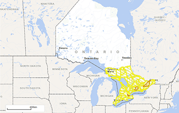
Current conditions map
Low water or drought in Ontario.
Low water definitions
- Low Water Level 1: early indication of a potential drought condition.
- Low Water Level 2: increased likelihood of drought conditions.
- Low Water Level 3: high likelihood of drought conditions (does not imply an emergency).
Learn, prepare and act

Learn
SWMC is the source of information to learn about flood or drought risks in advance of an emergency.

Act
Conservation authorities and municipalities act on natural emergencies by sending out timely public information.
Flood and low water data
Water Managers or Agencies can get access to all the water management data and details of Ontario’s flood and low water research and reports.