Protecting people and property: Ontario’s flooding strategy
Read Ontario’s flooding strategy, containing actions to better protect people and property from the effects of flooding.
Message from the Minister

Minister of Natural Resources (MNR)
The flooding that impacted extensive areas of the province in the spring of 2019 was a reminder that communities all around Ontario are vulnerable to these frequent, naturally occurring events. Premier Doug Ford and I saw first-hand the devastating effect the flooding had on the people of Ontario.
In the weeks and months afterward, our government heard from people in communities across the province, calling for action to address the serious issue of flooding.
Building healthier and safer communities is our number one priority and that’s why we have been taking action to strengthen Ontario’s preparedness for flooding. I am very pleased to present Ontario’s Flooding Strategy, which has been developed after extensive public consultations held around the province and online.
The strategy also draws on the expert advice of Doug McNeil, Ontario’s Special Advisor on Flooding. After last spring’s flooding, we knew we needed an external perspective—someone who could provide independent advice on improvements we can make. I would like to once again thank Mr. McNeil for his counsel.
We know that we can’t prevent flooding in Ontario—we can only reduce the impacts when it happens. This strategy is designed to help us do just that, by introducing a series of new and enhanced actions that will reduce flood risks and make our province better prepared for flooding events, better equipped to respond to them, and more capable of recovering from them quickly.
We have been working across government to strengthen our approach to flooding in the province. This will ensure that our actions as a government are well-coordinated and as effective as possible in protecting people and property.
But in order to succeed, we can’t act alone. We all have a role to play to become better prepared for flooding. Our government will work in collaboration with municipalities, the federal government, homeowners, conservation authorities, industry and Indigenous communities and together we can build a stronger Ontario.
Hon. John Yakabuski
Minister of Natural Resources
Flooding in Ontario
Flooding is common in Ontario and is a natural process.
Flooding becomes a hazard when it poses a threat to people, property or the environment. As noted by the Royal Commission Inquiry into the Grand River Flood, “As long as people continue to live in the flood plains, there will be flood victims.” Source: Report on the Royal Commission Inquiry into the Grand River Flood, 1974.
Flooding is often the result of heavy or prolonged rainfall, snowmelt, or a combination thereof. Localized high intensity, short duration rainfall events often associated with severe thunderstorms can cause flooding, particularly in urban watersheds. Ice jams associated with frazil ice formation and/or spring break up have also resulted in severe flooding and there is some concern that autumn ice jams may be becoming more common. High water levels and/or high winds on the Great Lakes can also result in shoreline flooding.
Flooding along Ontario’s rivers, lakes and streams can occur at any time of the year and there is concern that the likelihood of extreme weather and flooding will increase with a changing climate.
Even small changes in watershed conditions, such as increased water in soil, wetlands and lakes, can increase flooding risk.
Many watercourses in Ontario have flood-susceptible development nearby that was constructed before current planning policies were put in place. In other areas, buildings that were once seasonal cottages built to withstand periodic flooding have been converted into year-round homes with finished basements and other renovations that may make them more susceptible to flood damage.
Flooding is considered the most significant natural hazard in Ontario in terms of death, damage and civil disruption and is the costliest type of natural disaster in Canada in terms of property damage. The most severe flooding on record with respect to loss of life in Ontario occurred in October 1954 when Hurricane Hazel passed over the Toronto area. Eighty-one lives were lost and the cost of damage is estimated to be upwards of $1 billion (in current dollars).
The Insurance Bureau of Canada has determined that property and casualty insurance payouts from extreme weather have more than doubled every five to ten years since the 1980s.
While insurable payouts averaged $400 million per year from 1983 to 2008 in Canada, they exceeded $1 billion per year for eight of the last nine years, leading up to 2017. Nationally, spending on flood-related damage accounts for 75% of all weather-related expenditures.
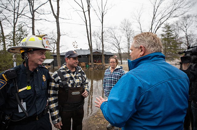
Premier Doug Ford tours a flood impacted area in Spring 2019.
Ontario’s approach to managing flood risk
As noted in Ontario’s Special Advisor on flooding’s report, Ontario has a well-established approach to managing flood risk, which is based on the core components of emergency management:
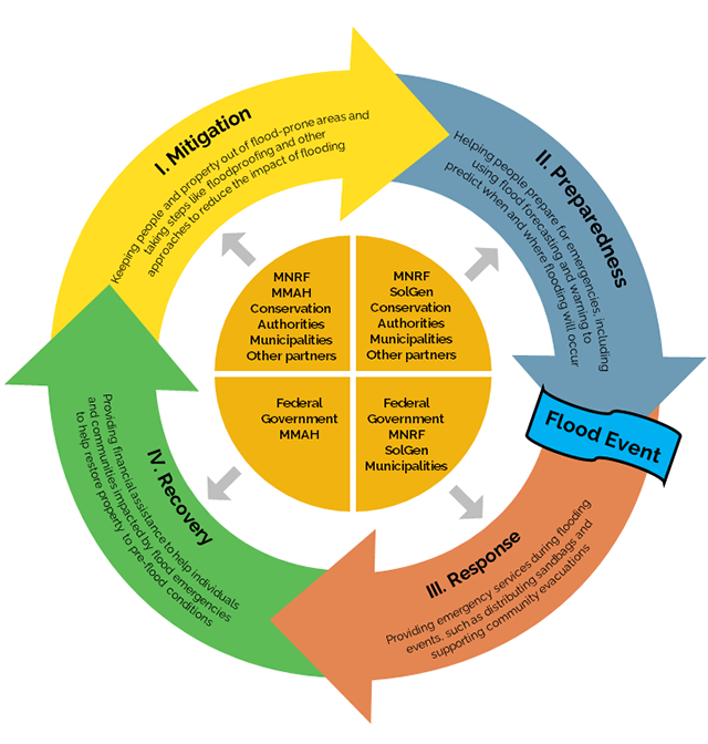
The diagram above and listed text below describes the 4 pillars of emergency management related to flooding.
- Mitigation
- Keeping people and property out of flood-prone areas and taking steps like floodproofing and other approaches to reduce the impact of flooding
- Ministry of Natural Resources
- Ministry of Municipal Affairs and Housing
- Conservation authorities
- Municipalities
- Other partners
- Keeping people and property out of flood-prone areas and taking steps like floodproofing and other approaches to reduce the impact of flooding
- Preparedness
- Helping people prepare for emergencies, including using flood forecasting and warning to predict when and where flooding will occur
- Ministry of Natural Resources
- Ministry of the Solicitor General
- Conservation authorities
- Municipalities
- Other partners
- Helping people prepare for emergencies, including using flood forecasting and warning to predict when and where flooding will occur
Flood event occurs
- Response
- Providing emergency services during flooding events, such as distributing sandbags and supporting community evacuations
- Federal government
- Ministry of Natural Resources
- Ministry of the Solicitor General
- Municipalities
- Providing emergency services during flooding events, such as distributing sandbags and supporting community evacuations
- Recovery
- Providing financial assistance to help individuals and communities impacted by flood emergencies to help restore property to pre-flood conditions
- Federal government
- Ministry of Municipal Affairs and Housing
- Providing financial assistance to help individuals and communities impacted by flood emergencies to help restore property to pre-flood conditions
Flood risk management is achieved through multiple provincial acts, regulations, policies and technical guides and a wide range of provincial programs and services. Successful implementation relies on partnerships between provincial ministries, municipalities, Indigenous communities, conservation authorities, stakeholder organizations and the federal government.
The Ministry of Natural Resources (MNR) is the provincial lead for flooding. Additional provincial direction is provided by the Ministry of the Solicitor General, the Ministry of Municipal Affairs and Housing, the Ministry of Infrastructure, the Ministry of Transportation, the Ministry of Agriculture, Food and Rural Affairs and the Ministry of Environment, Conservation and Parks, based on established roles and responsibilities.
Municipalities and conservation authorities are central to the success of local flood management, having distinct delegated roles from the province along with legislated and regulatory responsibilities to ensure new development is directed away from natural hazards. Other agencies including the International Joint Commission, Water Control Boards and Ontario Power Generation also play critical roles.
Individuals, including property owners, also have an important role to play in mitigating the impacts from flooding. Understanding flood risks, taking steps to reduce potential losses and being prepared in the event of a flood emergency are effective measures in which everyone can participate.
While Ontario has a well-established approach to managing flood risk and has benefited greatly from the comprehensive framework it has put in place, the significant losses associated with flood events in recent years indicates there is room for improvement.
Ontario’s Flooding Strategy seeks to build on the success of Ontario’s existing model and its collaborative approach to managing the risks of flooding by identifying a comprehensive set of actions that, taken together, will help to further strengthen Ontario’s resiliency to flooding, erosion and other natural hazards.
Introduction to Ontario’s flooding strategy
The Government of Ontario is committed to making Ontario more resilient to flooding. Resilience is the ability of a system to absorb or recover from impacts while maintaining the same state or essential function. This Strategy outlines steps to be taken by Ontario over the next several years to help achieve this goal. This Strategy contains actions that are designed to address and build upon the recommendations identified by Ontario’s Special Advisor on Flooding and are informed by the following principles of effective flood management.
Principles of effective flood management
- Local governments hold the primary responsibility for identifying and managing flood risks.
- Provincial and federal governments must play a key role in supporting local decision-making.
- Local decisions on how to best manage flood risks need to be based on the latest data and science.
- The most cost-effective and sustainable way of reducing risks is to keep people and property out of high-risk areas.
- Where development exists, systems must be in place to support effective early warning and emergency response.
- Recovery efforts are most effective when they incorporate the principle of “build back better” – an approach to post-disaster recovery that reduces vulnerability to future disasters and builds community resilience.
- We all have a role to play – risks should be managed in strong partnership with municipalities, conservation authorities, the federal government, private landowners, industry, and Indigenous communities.
Successful implementation of the actions contained within this Strategy will require support from all levels of government, businesses and residents. The province is committed to working with municipalities, the federal government, homeowners, conservation authorities, industry and Indigenous communities to advance the actions contained within this Strategy.
Each priority area is supported by a comprehensive set of actions and associated activities to be taken by the province over the next several years to help achieve the goals and objectives outlined within this Strategy and thereby increase Ontario’s resiliency to flooding.
Goals:
- increase public health and safety
- reduce property and environmental damage
- reduce economic losses
- reduce social disruption
- reduce public and private expenditures
- reduce critical infrastructure disruption
Priorities:
- understand flood risks
- strengthen governance of flood risks
- enhance flood preparedness
- enhance flood response and recovery
- invest in flood risk reduction
Objectives:
- keeping people and property out of high-risk areas and not creating new, or aggravating existing flood risks
- reducing the impacts of flooding on existing communities
- ensuring Ontarians are aware of flood risks and are taking steps to prepare for them
- ensuring efficient and effective services are in place to respond to flood-related emergencies when they occur
- ensuring Ontarians impacted by flooding can get back on their feet as soon as possible
Priority #1
Understand flood risks
To effectively manage the risks posed by flooding, we must understand what the risks are and make decisions on how to manage flood risks, informed by the best science and information available. Understanding flood risk in Ontario is a vital first step in improving the ability of the province to reduce impacts of flooding. This priority seeks to increase municipal and government understanding of flood risk in Ontario. The intended outcome of this priority is to ensure Ontarians, including municipal and provincial agencies, are aware of the flood risks, how these can be mitigated and how risk management decisions are made.
Defining flood hazard limits, preparing flood maps and developing appropriate land use planning policies that reflect the identified hazardous areas is the current and most effective approach to hazard mitigation and management in Ontario.
Clear, defensible and scientifically driven survey and mapping standards for flood and other water-related natural hazards are important to support:
- municipal land use planning (Planning Act)
- protection of people and property against risk of natural hazards by conservation authorities (Conservation Authorities Act)
- emergency management and response (Emergency Management and Civil Protection Act)
As noted in the report by Ontario’s Special Advisor on Flooding, the management of floodplains and other hazardous areas begins with their identification. Ontario uses strong land use planning policies to protect people and property. The underlying principle is to identify where natural hazards occur, such as floodplains, and concentrate development away from them.
As a tool, accurate mapping ensures that applicable authorities direct development away from areas that pose unacceptable risks to public safety.
The identification of hazard areas supports municipalities and planning authorities in implementing the Provincial Planning Statement and helps conservation authorities to undertake their mandated role in preparing for and protecting against the risk of natural hazards under the Conservation Authorities Act.
Although the actual floodplain line can be dynamic, having accurate flood maps as a tool can help communities make efficient and effective planning decisions and provides clarity for developers and home owners. The usefulness of flood maps also extends into other aspects of flood management such as emergency management. The Office of the Auditor General suggests that up-to-date flood maps would allow municipalities to better plan for future growth in areas of low flood risk and build infrastructure resiliency in high-risk flood areas.
Flood management involves multiple agencies across government. Each agency may participate in a range of roles including flood mapping, flood forecasting and warning, land use planning, water management and emergency response. A common need across all agencies is the ability to access and reference accurate flood mapping information.
Ontario’s Flooding Strategy seeks to advance and enhance flood mapping in Ontario by creating an integrated, sustainable and systematic provincial flood mapping program designed in partnership with municipalities and conservation authorities. Through implementation of the following activities, sound local decisions will be able to be made based on current data and mapping.
Activities
Establish a multi-agency flood mapping technical team
To ensure a collaborative and strategic flood mapping program, the province will establish a multi-partner flood mapping technical team. This team, consisting of staff from provincial and federal government agencies, municipalities, conservation authorities and academia, will coordinate the activities within this action as well as provide input into the review and update of current flood mapping technical guides, as outlined in Priority #2.
Develop a multi-year approach to updating flood mapping
The Flood Mapping Technical Team will be responsible for developing a multi-year approach to updating flood mapping. Recent funding provided to municipalities and conservation authorities under the National Disaster Mitigation Program (2015-2020) has enabled some areas around the province to update their flood mapping. While these updates are supported by the province, updates have been made based on the initiative of the municipality or conservation authority in applying for funding from the federal government and were not necessarily strategic in nature.
To develop a multi-year approach, the Team will:
- evaluate the state of flood mapping
- identify priority areas for updating or producing new flood mapping
- determine the costs associated with various technological options to update mapping
- evaluate opportunities for funding partnerships
- establish a working group with provincial agencies to identify custodians for flood mapping information, including base data, with clear roles and responsibilities
- create mechanisms for data sharing, data maintenance, data access and data distribution
- make necessary updates to policies, regulations and legislation to ensure flood mapping information can be shared with other agencies and the public
This multi-year approach will be aligned with federal commitments to work with the provinces and territories and Indigenous communities to complete all flood maps in Canada.
Funding for floodplain mapping
From 2015 to 2019, municipalities and conservation authorities received approximately $9 million in matched funding towards updating flood maps across Ontario for a total investment of at least $18 million. Approximately $81 million has been secured for flood-related initiatives in Ontario for four funding areas: risk assessments, mapping, mitigation planning and non-structural and small-scale structural mitigation projects.
Maintain flood-related foundational geospatial data
Foundational geospatial data is critical to flood management because it serves as authoritative data for the entire flood mapping process. When combined with quality assurance through field validation, this data supports all aspects of flood management, from flood mapping to land use planning and flood mitigation. Two primary geospatial datasets are used in flood mapping:
- imagery data, for two-dimensional feature positions such as roads, rivers and buildings
- elevation data, for three-dimensional heights such as height of river bank or of roads
The province will support the creation and maintenance of foundational geospatial data, including:
- continue collaborating with many partners in the public and private sectors, to acquire and deliver high-resolution imagery on a 5-year cycle
- ensure that the acquisition and delivery of high-resolution imagery continues to provide seamless coverage of southern Ontario and corridors of coverage over most populated areas in Ontario
- continue with imagery acquisitions in the future to allow changes to the urban and natural landscape to be considered for flood management
Establish a provincial elevation mapping program
In 2016-18, the provincial and federal government collaborated to collect Light Detection and Ranging (lidar) elevation data across portions of south-western Ontario. lidar is an optical remote-sensing technique that uses laser light to densely sample the surface of the earth, producing highly accurate measurements in three dimensions. This data has been used by municipalities and conservation authorities for flood mapping, however many other areas of the province lack current and accurate elevation mapping.
To support an effective flood mapping program, the province will:
- explore creating a Provincial Elevation Mapping Program which will:
- identify how to prioritize on the acquisition of elevation data
- identify costs associated with data acquisition, information infrastructure and staff resources
- distribute elevation data as Open Data in order to maximize access for agencies and the public, spur innovation and support economic growth and use beyond flood management
- ensure elevation data acquisition standards and maintenance targets are aligned with provincial flood mapping technical guides
Update provincial standards for flood mapping
To support effective and consistent approaches to flood mapping and provide support and guidance to the community of mapping practitioners in Ontario, the province will incorporate advancements in flood surveying and mapping technologies including new and emerging data acquisition methods, by developing standards to ensure the consistency and accuracy of flood and other water-related hazard mapping across the province, regardless of the data acquisition methods employed. This initiative will:
- Develop and consult on provincial direction for survey and mapping specifications, requirements and standards, recognizing new technologies, approaches and accuracy standards for flood hazard mapping and other water-related natural hazards.
- Investigate additional types of mapping formats to supplement flood hazard mapping that is used to support land use planning. This could include flood risk (emergency management and response mapping) and other forms of mapping that may be useful to the public.
- Collaborate with municipalities and conservation authorities including the multi-agency Flood Mapping Technical Team.
- Examine the suitability of consolidating survey and mapping guidance for the purpose of addressing all water-related natural hazards.
- Provide clear guidance that enhances consistency across the province, ensuring the relative accuracy and representativeness of mapping products while also providing mechanisms to address varying survey and mapping requirements based on the risk posed to people and property.
- Explore opportunities to standardize mapping content and cartographic requirements for existing and any new formats of flood mapping.
- Ensure that provincial flood mapping technical guidance is aligned with provincial elevation data acquisition and maintenance targets.
The Ontario government wants to help Ontarians understand the risks posed by flooding and the steps they can take to try and mitigate them.
This includes working with partners to ensure Ontarians are provided with information on the water management systems and decisions made regarding the Great Lakes, inland lakes and rivers where they live, work and play.
Ontario’s Flooding Strategy seeks to make Ontarians aware of the risks posed by flooding and what can be done to manage them. By implementing the following activities, Ontarians will be better equipped to take steps to minimize the effects of flooding.
Activities
Increase access to flood-related information
To support public awareness by providing information, Ontario will:
- create a public education and outreach program designed to help Ontarians understand the risks they face and steps that they can take to prepare – including creating a central provincial website that provides information on commonly asked questions about flooding and weblinks to publicly available resources
- use the results of Ontario’s first broad, multi-sector provincial climate change impact assessment to provide Ontarians with a greater understanding of flood risk in the province
- work with partners like Conservation Ontario, the Association of Municipalities of Ontario, the Intact Centre for Climate Adaptation, the Institute for Catastrophic Loss Reduction and the Insurance Bureau of Canada to share best practices for identifying and responding to flood risks and building resilience
- work with the real estate and insurance industries to raise awareness among homeowners about the increasing risk of flooding
- work collaboratively with Ontario ministries and municipal partners to ensure the public has access to traveller information and all-flood related road closures on the Ontario 511 website
Increase transparency around water management decisions
Ontario’s Special Advisor on Flooding confirmed that, based on an analysis of the information available for all systems that experienced flooding in spring 2019, nothing pointed to human error or the negligent operation of water control structures as the cause of the flooding. The sheer amount of water (snow and rainfall) on the landscape directly contributed to the flooding. Measures taken by water managers everywhere were effective in reducing the magnitude of flooding and associated damage throughout the drainage basins. However, the Special Advisor on Flooding also identified several opportunities for improving communication about water management in Ontario during times of flooding. Local water managers, as partners to the province, play a significant role when it comes to managing water resources including where possible, manipulating operations to minimize the impacts of high-water levels.
To increase public understanding of the complexities of local water management and the decision-making process involved in managing water levels, Ontario will:
- Encourage the federal government (Public Service and Procurement Canada) to initiate a review of the Lake Nipissing Operational Guidelines.
- Engage with municipalities and other watershed partners in the Muskoka and Magnetawan watersheds regarding the establishment of a communication protocol. Key intentions of the protocol will be to inform municipalities and partners of watershed conditions and improve understanding of the complex suite of factors that are considered in water management. This would contribute to an environment where municipalities are informed and engaged on the critical operational decisions that are made to balance the interests across the watershed. Should the protocol prove useful, opportunities to implement the protocol in other areas of the province that could benefit will be explored.
- Facilitate a meeting with the Upper Ottawa River Watershed stakeholders to discuss developing a structured approach to sharing water management information during spring freshet. Ontario will use its experience with the Sturgeon-Nipissing-French Water Management Group when considering the development of a more formal structure.
- Increase transparency through real-time monitoring of sewage overflows from municipal wastewater systems into Ontario’s lakes and rivers, work with municipalities to ensure that proper monitoring occurs and inform the public of overflow incidents.
- Facilitate dialogues with water management partners, including the International Joint Commission, the Ottawa River Regulation Planning Board, Ontario Power Generation and others to develop opportunities and tools which will:
- increase understanding of local management and structural operations
- increase public access to real time data, water level forecasting and post-flood analysis
- increase clarification regarding organizational roles and responsibilities and provide opportunities to evaluate current policies
Priority #2
Strengthen governance of flood risks
Flood management responsibilities are carried out by several provincial and local agencies. A key role of the province is to develop policy. Municipalities, along with conservation authorities, where they have been established, implement these policies at a local level. Policies are implemented through a wide array of tools including legislation, regulation and technical guides. Partner agencies, including water power producers and water control boards, also have varying levels of influence in managing water flows and levels. With the number of agencies and tools involved, governance can be confusing, and policies can slip through the cracks. The province acknowledges the need to clarify these roles and responsibilities and ensure policies are being implemented appropriately with all applicable partners. The goal of this priority is to ensure all the agencies involved in flood management work together to minimize the risks of flooding. The intended outcome of this priority is to have consistent application of provincial policy, and to ensure that local development is directed away from areas which present unacceptable risk.
Several different agencies and levels of government share roles and responsibilities for the management of flooding and other natural hazards.
Some of these roles are clearly defined in legislation and regulation, while others have evolved over time and may not be clearly assigned to individual organizations or sufficiently documented.
While it is important that there be clear lines of accountability for the various parties involved in flood management, the reality is that some mitigation, preparedness and response roles must be shared between municipalities and multiple ministries by nature of the services they provide.
As noted by the Special Advisor on Flooding, when roles and responsibilities are shared amongst several different agencies, it diffuses control, expertise and ultimate decision-making and accountability among the agencies. In order to limit these outcomes, Ontario’s Flooding Strategy seeks to clarify and communicate roles and responsibilities for flood management and increase accountability for decisions regarding flood management.
Activities
Clarify roles and responsibilities in identifying natural hazards
As part of their responsibility to manage natural hazards, the province, municipalities and conservation authorities all have the mandate to identify areas that may pose a risk to the public.
- The province will work with these partners to clarify provincial, municipal and conservation authority roles and responsibilities for identifying hazardous areas.
Conservation authorities have a long-standing partnership with the province and municipalities in delivering a range of natural hazard management programs and services, that has been assigned through various non-legislative or regulatory mechanisms over many decades.
- The province will work with municipalities and conservation authorities to create a regulation under the Conservation Authorities Act outlining mandatory programs and services to be delivered by conservation authorities related to the risk of natural hazards. This could include standards and requirements for the delivery of those programs and services.
Conservation authorities
Each of Ontario’s 36 conservation authorities currently regulate development and other activities through a permitting process under Section 28 (1) of the Conservation Authorities Act. These regulations support the role conservation authorities play in preparing and protecting against the risk of natural hazards.
Clarify urban flooding roles and responsibilities
Gaps exist in the responsibility for managing some types of flooding such as urban flooding, which is caused by excessive runoff in developed areas where the water doesn’t have anywhere to go. Even residents who don’t live near a body of water could be at risk of flooding in these situations.
- Ontario will establish an Urban Flooding Work Group with representatives from the Ministries of Natural Resources, Environment, Conservation and Parks, Municipal Affairs and Housing, Infrastructure and Transportation, as well as select municipalities. The priorities of the Work Group will be to identify roles and responsibilities related to urban flooding, determine new or emerging urban flooding issues and develop a provincial framework for urban flooding policy.
As noted by Ontario’s Special Advisor on Flooding, Ontario has a robust framework for land use planning policy that has gone a long way to reduce and mitigate flood risks in the province, but there is room for improvement.
While the legislative, policy and regulatory framework has been in place for several decades, concerns have been raised regarding local implementation of these policies and the associated technical requirements. In some cases, new or intensified development has occurred in or adjacent to flood-prone areas that has not been consistent with the policy framework. The framework is intended to prohibit development in these areas, or in special circumstances such as Special Policy Areas, allow for strictly limited development in historic communities in the floodplain. Consideration of other planning interests, including financial and economic rationale, have been used to help justify these types of decisions. These decisions often result in greater reliance on other tools in the continuum of the emergency management framework. These include structural mitigation measures like flood protection berms and floodproofing. They also include flood warning systems, temporary sandbag dikes, disaster assistance and/or insurance. Reliance on these tools indicate less adherence to an avoidance-first approach to managing the impacts of flooding, resulting in increased risks and greater long-term costs.
Ontario’s Flooding Strategy seeks to enhance Ontario’s land use planning framework to ensure municipalities make decisions consistent with provincial policies and that development, redevelopment and intensification continues to be directed away from areas where flooding and erosion present unacceptable risks to people, property and the environment.
Activities
Update the Provincial Policy Statement
The Provincial Planning Statement provides policy direction on matters of provincial interest related to land use planning and development, sets the policy foundation for regulating the development and use of land, and supports the provincial goal of enhancing the quality of life of all Ontarians.
Natural hazard policies, including those related to flooding hazards are found in Section 3.1 of the Provincial Policy Statement. These policies generally direct development away from hazardous areas, including areas associated with flooding hazards. Municipalities implement this policy direction in a variety of ways, with the most common approaches being hazard land designations and associated policy direction in official plans and zoning by-laws which outline permitted uses in these areas. Municipalities may also work with local conservation authorities to include hazard land mapping and schedules in planning documents.
From July 22 through October 21, 2019, the Ontario government consulted on the proposed policies of the Provincial Policy Statement through a posting on the Environmental Registry of Ontario and meetings with municipal and stakeholder groups. A separate Indigenous engagement process also occurred in the fall of 2019. Given the Special Advisor on Flooding’s review commenced in July, the decision was made to delay proposed changes to the natural hazard policies related to flooding hazards until his report was received and recommendations considered.
In response to the Special Advisor on Flooding’s recommendation dealing specifically with the Provincial Policy Statement, as well as additional feedback received through the broader consultation, the province incorporated the following natural hazard policy changes in the 2020 Provincial Policy Statement, to better show the linkages between land use planning and natural hazard management:
- added reference to the “impacts of a changing climate” in the Section 3.0 Preamble to highlight the unknown realities of our changing climate and the need to consider heightened awareness of these realities in natural hazard planning decisions
- acknowledged in the Section 3.0 Preamble, the role conservation authorities play in preparing and protecting against the risk of natural hazards
- added a reference in the infrastructure policy section (1.6.4) to ensure the natural hazard policies are considered when locating infrastructure and public service facilities
- strengthened the linkage between the Provincial Policy Statement natural hazard policies and the provincial technical guides, which outline direction set by the province for implementing the natural hazard policies
- enhanced existing stormwater management policies to support commitments in the government’s Made-in-Ontario Environment Plan to protect water and support climate resilience
Update existing technical guidelines
The existing approved series of natural hazard technical guides used to support municipal and conservation authority implementation of provincial natural hazards were created between 1996 to 2002. Science and technology have moved rapidly since this time and, as was clearly noted by the Special Advisor on Flooding, a review of the existing guidance including updates as required is warranted.
This includes addressing new and emerging hazard management issues and mitigative measures that have arisen during the intervening time, which are not consistent with current policies and approaches.
The province will undertake a comprehensive review of Ontario’s natural hazard technical guides, with a focus on flooding and erosion, and will:
- examine and analyze existing flood level values specified on the Great Lakes – St. Lawrence and connecting channels, considering recent high-water levels and what may be predicted under a changing climate
- evaluate the hazard methodologies of shoreline erosion along the Great Lakes and allowances in the context of newer or emerging methods
- evaluate riverine flood standards relative to their sensitivity to be affected by climate change
- evaluate hydrologic and hydraulic methodologies included in existing technical guides
- assess existing policies and approaches for designating and defining floodplains, including concepts around the use of the floodway and flood fringe concepts, particularly in the context of development
- review floodproofing guidance and make recommendations on updates to existing guidance including an examination of the suitability of consolidating floodproofing guidance for addressing flooding across riverine, large inland lakes and Great Lakes guidance
- evaluate existing Special Policy Area policies and procedures
- where appropriate, proceed with updates to items listed above if they are found to be outdated or if there are methods or standards determined to be better suited to protecting people and property
Review policy and ideological approaches of existing guidance
In recent years, increasing development needed to support a growing population and economy has created pressure on the province and municipalities to adopt a more structural-based approach to flood mitigation. Structural measures for flood mitigation, including regional flood control facilities, berms and flood protection landforms, are seen by some as representing opportunities to either ‘protect’ existing communities from flooding, or to open up new development opportunities in previously identified hazardous lands. The province has not supported shifting policy in this direction for a number of established reasons. Existing policies do not support using structural approaches to flood mitigation to open new areas for development. Structural measures are costlier to build and maintain, are not resilient to climate change and present increased residual risks to people and property if these structures fail. Berms, dykes, flood protection landforms and other structural measures can be overtopped, making flooding worse and failing to keep people and property out of the floodplain, often inspiring a false sense of security, thereby encouraging further development in hazardous areas.
Despite the existing policy prohibition, Ontario is seeing these structures proposed more often to solve local land use planning and hazard mitigation issues. Considering this, and stemming from recommendations from the Special Advisor on Flooding, the province will undertake the following activities to evaluate existing policies and their overarching approaches related to the use of structural measures.
- Evaluate the strengths, weaknesses, opportunities and threats of adopting a flood management approach that includes increased use of structural approaches to flood mitigation through the use of berms, dykes and flood protection landforms, that could include adopting these measures into technical guidance for rivers and streams, large inland lakes and the Great Lakes.
- Further evaluate the use of regional flood control facilities in Ontario and determine whether the province should take steps to regulate their use while considering a range of options from allow to prohibit.
- Explore policy options regarding the use of structural measures.
- Work with municipalities, conservation authorities and the development sector to explore adopting a risk-based approach to flood management in Ontario that would support:
- setting risk-management objectives
- identifying and assessing risks
- developing and evaluating strategies to reduce risk
- monitoring, evaluating and reporting on how risks are being managed
- continuously improving management activities as part of an adaptive management framework and continuous improvement process
- applying flexible adaptation strategies that can change over time and preserve other flood risk management options
Maintain wetlands and pervious surfaces
- Develop policy tools and approaches to prevent new wetland loss and work towards the net gain of wetlands in Ontario, focusing on areas where wetland loss has been the greatest including:
- maintaining and improving policy and approaches to encourage wetland conservation on private land
- consolidating and improving wetland mapping between municipal, conservation authority and provincial agencies through the adoption of provincial wetland mapping standards
- developing best management practices for wetland creation/restoration as part of green infrastructure or alternatives to traditional drainage works and infrastructure to help build resilience and improve other ecosystem services
- evaluating the effectiveness of existing policies and approaches to encourage wetland conservation on private land, such as tax incentive programs
- exploring approaches to integrate the economic value of wetland ecosystem services into decision-making, such as promoting green infrastructure alternatives to traditional infrastructure
- maintaining and strengthening partnerships such as the Ontario Eastern Habitat Joint Venture with Ducks Unlimited Canada that work to promote, conserve and restore Ontario wetlands
- continuing to work with partners to address threats to wetlands, including detection, monitoring, removal and control of invasive species
- continuing to support Great Lakes policies and initiatives for wetland conservation aligning with the commitments made in the Canada-Ontario Agreement on Great Lakes Water Quality and Ecosystem Health
- Continue to encourage and promote municipal use of Ontario Provincial Standard Specification OPS 356 “Construction Specification for Pervious Concrete Pavement for Low-Volume Traffic Applications”.
- Provide guidance on the use of green infrastructure to reduce stormwater runoff that is considered in long-term infrastructure planning and land use decisions, which may help improve flood mitigation and climate resilience.
Enhance the resiliency of provincial infrastructure and other built form
- Promote the broad use of location-specific Intensity Duration Frequency curves developed and utilized since 2016 as part of the implementation of Climate Change Consideration in the design of highway drainage infrastructure.
- Account for climate change consideration in the design and rehabilitation of urban, rural and agricultural drainage works within the province, including reviewing provincial standards for drainage pipe capacity.
- Identify further climate change impacts on provincial infrastructure assets including accelerated asset deterioration due to increased frequency and severity of extreme precipitation events.
- Facilitate the development of adaptation strategies to increased frequency of inundation of provincial infrastructure, including consideration for altering zoning and land use, change of building codes and condition assessment of aging infrastructure.
- Utilize available weather data and climate change projections in long-term provincial infrastructure planning.
- Encourage municipalities to update their requirements for new development to mandate the use of higher intensity and duration storms in design standards.
- Encourage and support ongoing efforts by Metrolinx to improve and protect existing rail infrastructure, maintenance facilities and transit stations, for example, through design standards, operational procedures, asset management, flood mapping, etc. to enhance resiliency to flooding and washouts.
- Work with Conservation Ontario to minimize delays in the implementation of floodproofing mechanisms and the installation of public safety devices around conservation authority flood and erosion control infrastructure through proposed exemptions from environmental assessment requirements.
Streamlined work permits
New in 2019, Ontario streamlined the permit application process to allow property and homeowners to take immediate action to repair and avoid property damage. Property owners can now apply online for a work permit to conduct erosion control immediately, such as the installation of breakwalls or armour stone.
Update existing policy, legislative and regulatory requirements
Ontario has a strong flood management policy framework which has resulted in reduced flood impacts across communities. However, there are potential opportunities to improve the effectiveness and efficiency of the framework through new or expanded legislated or regulatory authority. Ontario will evaluate the existing framework and:
- update municipal wastewater policies and develop a new stormwater policy to improve the way stormwater is planned and managed over the long-term, in order to help communities mitigate the impacts of flooding and extreme weather conditions
- review the Development, Interference with Wetlands, and Alterations to Watercourses and Shorelines regulations made under Section 28 of the Conservation Authorities Act
- consider legislative amendments to the Conservation Authorities Act that update the regulation of hazard lands and their relationship to land use planning approvals under the Planning Act
- explore whether new legislative or regulatory authority is required, such as:
- enshrining existing flood management technical standards into regulation to ensure flood mitigation activities are carried out in accordance with provincially approved standards
- enabling the establishment of regional hazard teams, including for flooding, which may be struck to work collaboratively toward common goals
- requiring municipalities to conduct flood vulnerability studies and develop resiliency plans and enhanced emergency plans for highly vulnerable areas
- creating a provincial one-window for all flood-related data and information collected and disseminated
Priority #3
Enhance flood preparedness
Flooding will continue to happen in Ontario, no matter the level of preparation for a flood event. By knowing when and where floods are more likely to occur, agencies and Ontarians can be better equipped when it happens. The goal of the priority is to ensure Ontarians have access to current and timely information in order to prepare for flood events. Increased preparedness for future flood events, by having access to up-to-date flood mapping, is the intended outcome of this priority.
As noted by Ontario’s Special Advisor on Flooding, flood forecasting and warning plays an important role in reducing risk to life and reducing property damage -particularly for residents located in a floodplain or flood vulnerable area where permanent mitigation works do not exist.
Climate change scenarios are indicating that Ontario may be exposed to more intense heavy rainfall events and corresponding flooding. A robust approach to flood forecasting and warning in Ontario will assist to prepare Ontario for future flood threats.
The goals of flood forecasting and warning are to increase lead time to:
- reduce the risk of loss of life, injury and property damage due to flooding by issuing flood messages and information to those that may be at risk and to those agencies and individuals that respond to the flood event
- maintain an understanding of the flood risk at the local watershed and provincial level
- provide information for the safe operation of dams
Ontario’s Flooding Strategy seeks to enhance the early warning system to ensure people are receiving the information they need to plan for and respond to flooding.
Activities
Maintain flood forecasting and warning
The province will continue to chair the Provincial Flood Forecasting and Warning Committee. The Committee provides a program link between agencies responsible for flood forecasting and warning, flow measurement and data collection. It also addresses policy and implementation needs and issues and facilitates training as needed. This includes a program link with other partners.
Continuation of this Committee will allow us to support and continue to:
- promote and provide input and direction to flood forecasting/warning and related programs
- represent the program’s partners, to review and recommend on matters of policy, standards, agreements, criteria, funding, training requirements and other components of the provincial flood forecasting and warning program
- facilitate discussion and dissemination of matters related to flood forecasting and warning which may include technological advancements, current challenges, training/education and other relevant topics
- promote the Ontario Flood Forecasting and Warning Implementation Guidelines to ensure standard messaging and communications
Successful implementation of this Flooding Strategy will involve collaboration with the Provincial Flood Forecasting and Warning Committee.
The province will continue its partnership arrangement with the federal government and the supporting financial commitment through the Canada-Ontario Agreement on Hydrometric Monitoring. This agreement outlines the co-management of a comprehensive stream monitoring network in Ontario.
The continuation of this agreement will allow us to support and continue to:
- provide information used by flood forecasting and warning professionals to support early warning for flood – allowing forecasters to make better informed decisions to keep Ontarians safe from floods
- monitor the effectiveness and location of stream gauges to ensure that there is appropriate coverage and where necessary repositioning gauges
The province will continue to maintain and update the Ontario Flood Forecasting and Warning Implementation Guidelines to:
- Ensure clarity on roles and responsibilities.
- Outline the essential components of a Flood Forecast and Warning system. This will include practical and real-life examples of the ranges (from simple to complex) of flood forecast and warning systems with recognition that each system should be designed to reflect the local watershed characteristics and resources.
- Provide templates for consistent flood messaging.
Funding for flood forecasting
Ontario is committed to its continued investment of over $4.7 million in the hydrometric (stream gauge) network to enable flood forecasting and flood warnings that help municipalities better prepare for flood events.
Flood forecasting
Flood forecasting and warning services are delivered by the ministry through its Surface Water Monitoring Centre in cooperation with local ministry work centres (which provide local level expertise and information) and conservation authorities (where they exist), through flood warning and watch messages to municipal responders. The ability to provide this service rests with information provided through the hydrometric network, a federal/provincial partnership and its 600 gauges across the province, more heavily concentrated in those watersheds of greatest population and therefore greatest risk of harm.
Enhance flood forecasting and warning
Ontario will continue to examine efficient means of enhancing flood forecasting and warning, and will:
- Implement a federal collaborative climate monitoring agreement between Ontario and other agencies that supports the sharing of weather data and will work towards making this information available in open data form. This agreement includes data from Environment Canada Weather Stations, ministry Stations, Ministry of Transportation road weather information and some conservation authorities.
- Assess the characteristics of stream gauge stations collaboratively with partners to determine the appropriate data transmission method. This could include satellite (Geostationary Operational Environmental Satellite), cellular internet protocol address, telephone, as well as dual and redundant communications.
- Review gauge alarming processes at stations in watersheds that exhibit a higher risk or quicker response to precipitation and snowmelt and where local flood thresholds are known. This will enable Ministry and conservation authority staff to define thresholds and request automated system notifications when water levels have exceeded a threshold of concern.
- Explore the value of additional manual snow monitoring locations in those watersheds where snow cover and snow water content are factors in spring flooding and formalize the process of using remote sensing products to better estimate the distribution of snow.
- Review the province’s Snow Network for Ontario Wildlife monitoring stations for the purpose of better supporting flood forecasting and warning. Harmonizing the Snow Network for Ontario Wildlife database with the Surface Water Monitoring Centre database by having Snow Network for Ontario Wildlife network contacts measure snow water equivalent when carrying out existing snow surveys. Implement a data portal that allows for expedited data submission and validation.
- Develop ways that citizens can play a role in collecting precipitation information, such as daily rainfall and snow depth.
- Work with federal, provincial, industry and local partners to support the sharing of data. This would not only allow partners to openly access a suite of water and climate data but enable additional partners to share their data and strengthen flood forecasting and warning. This data would be consolidated into the existing Surface Water Monitoring Centre hydrometric monitoring database.
- Evaluate existing provincial-scale flood modelling tools and explore the feasibility of providing longer-range forecasting capabilities and incorporating other tools.
Enhance science and research
Natural processes that contribute to flooding are changing. Continued research into the mechanisms responsible for flooding is required to ensure that we are continually learning about and are able to adapt to these changes. Ontario will work to identify and advance science and research projects in support of enhancing and validating flood forecasting and warning efforts by the province and will:
- Establish or use existing experimental watersheds to validate, calibrate and improve existing models or to develop new models.
- Clarify relationships between watershed conditions and high flow events. Of interest are changing snow and ice conditions, including effects of mid-winter melt events, changing frozen ground conditions, rain-on-snow events and changing spring runoff processes.
- Explore the relationship between trends in the magnitude, duration, frequency and timing of high flow events, water balance dynamics and changing water conditions.
- Explore the use of remotely sensed imagery to operationally monitor the hydrological conditions of a watershed associated with flooding.
- Explore the feasibility of using a low-cost micro computer-based data collection and transmission system for community monitoring of hydrologic state variables of sufficient accuracy to meet program needs.
Enhance use of satellite imagery
- Continue to support flood-related emergency response efforts in northern Ontario by acquiring, processing, interpreting and distributing satellite imagery in near real-time including:
- continuing satellite monitoring efforts targeted to major rivers flowing into Hudson Bay and James Bay, including the Moose, Albany, Attawapiskat, Severn and Winisk - during the spring ice break-up period between March and May
- continuing to work with the Canada Centre for Remote Sensing in Natural Resources Canada and Public Safety Canada in the flood and ice monitoring of the major rivers flowing into Hudson Bay and James Bay
- Work with federal partners to seamlessly integrate imagery from the three new Canadian radar satellites (RADARSAT Constellation Mission) into existing provincial flood and ice condition mapping and monitoring processes for northern rivers.
- Explore the technical and logistical requirements and costs associated with expanding satellite-based flood monitoring and mapping services to ensure year-round and province-wide mapping and monitoring of flooding on major northern rivers to support emergency management efforts.
- Explore the utility of providing a wider range of satellite services, tool development, process automation, training and science transfer in collaboration with federal partners.
- Explore opportunities to leverage satellite data to monitor critical flooding attributes such as snow extent, snow water equivalent, flood extent, water levels and antecedent moisture conditions and implement provincially if feasible.
Maintain Ontario’s road weather information system
The Ontario 511 website supports the Ontario Flooding Strategy by raising awareness when flooding is impacting highways and the travelling public. Ontario 511 as a public communication tool can share key messages and direct users to the best source for flooding information using an engaging platform.
Ontario 511 registered users can be notified through phone or email through the website’s emergency alert opt-in function when flooding is predicted to have a major impact, especially as it pertains to road washouts and highway closures. In addition, the website has an emergency information panel on its front page that, when used, becomes the first information a user sees when visiting the website. The website also features a newsroom where more detailed news and information can be posted. Ontario 511 is also active on Twitter and can share information on flooding.
In addition to Ontario 511, the provincial government will:
- undertake trial projects to evaluate the effectiveness of snowfall intensity measurements collected through the Road Weather Information Systems Network and sensors that can approximate snowfall intensity using visibility sensors
- undertake trials using mini-Road Weather Information Systems stations that are solar powered for areas without access to power
- construct 24 new Road Weather Information Systems stations across the province and provide access to municipal station data through data sharing agreements
- support provincial flood forecasting and warning initiatives through increased real-time and historical weather data sharing
- work on field instrumentation projects using Road Weather Information Systems
- work with service providers to develop forecasting products
The Ontario government will continue to utilize Ontario 511 traveller information services to raise awareness when flooding is impacting provincial highways and the travelling public. Ontario 511 will also notify users that are registered for “Emergency Alerts” through text or email when flooding is predicted to have or is currently causing a major impact to provincial highways.
Priority #4
Enhance flood response and recovery
Flooding is inevitable even when all planning and early warning measures are executed completely. How the province and municipalities respond to flood events is critical to ensure the safety and recovery of people and property and our communities. The goal of this priority is to ensure emergency response and recovery programs are well coordinated and effective in supporting communities and Ontarians in their time of need. Ensuring the people of Ontario receive the support they need to respond to and recover from flood emergencies would be an intended outcome for this priority.
Response is one of the interdependent components of emergency management in Ontario.
Response includes actions taken to address and deal with the impacts of a flood emergency, such as providing logistical support, sandbags, social and health services, and the taking of emergency actions such as community evacuations during flood events.
Preparing for response can include training for emergency response staff and meeting with stakeholders prior to a flooding emergency to create and maintain appropriate awareness of the threat and risks to ensure an effective response.
The Emergency Management and Civil Protection Act and its associated Ontario Regulation 380/2004 establishes Ontario’s legal basis and framework for managing emergencies and assigns roles and responsibilities to several provincial ministries and agencies, municipalities, the Commissioner of Emergency Management and the Chief of Emergency Management Ontario.
Ontario’s Flooding Strategy seeks to enhance flood emergency operations to ensure response efforts are effective, efficient and well coordinated and that Ontarians receive the support they need to respond to flood emergencies.
Supporting flood response
In spring 2019, the ministry provided approximately 890,000 sandbags to municipalities throughout southern and eastern Ontario and deployed over 60 Fire Ranger crews and additional support staff to many impacted municipalities.
Activities
Enhance emergency response activities
- Continue to implement the Auditor General’s recommendations for improving emergency management in accordance with a workplan and report on progress through existing business plans.
- Continue to encourage ministries to enhance their continuity of operations program on an annual basis.
- Finalize the procurement of an emergency management software solution which will make the interaction with communities during times of emergency more efficient. This solution will provide a more effective means of communicating and tracking support requests from municipalities to ensure that they are assigned, prioritized and actioned more quickly.
- Ensure that the process for requesting assistance is better understood by municipal officials during both their preparedness activities and during times of emergency.
- Continue to evolve the Incident Management System by developing updated guidance.
Provincially, financial assistance is delivered through two programs—the Disaster Recovery Assistance for Ontarians Program for homeowners, tenants, small owner-operator businesses and farms and not-for-profit organizations; and the Municipal Disaster Recovery Assistance Program for municipalities.
These programs provide funds for eligible expenses following a natural disaster to help Ontarians and municipalities recover from extraordinary costs.
The province is committed to ensuring that provincial disaster recovery programs are meeting the needs of Ontarians. In 2019, we expanded the household items eligible for assistance under the Disaster Recovery Assistance for Ontarians Program, updated the caps on them to provide more assistance to applicants and introduced a shorter, more user-friendly application form. The province also introduced a “build back better” funding pilot project under the Municipal Disaster Recovery Assistance Program to help municipalities affected by spring flooding make climate resilience improvements when rebuilding damaged infrastructure after the natural disaster.
The Flood Strategy seeks to ensure that areas recovering from flood disasters are well supported and better equipped to withstand future flood events.
Activities
Review the results of the municipal disaster recovery assistance pilot climate resilience incentive
- Review the outcomes of the “build back better” pilot project to determine whether integrating this type of funding into the Municipal Disaster Recovery Assistance Program offers good value for money for Ontarians.
- Review program materials to ensure municipalities have clear information regarding eligible items under the Municipal Disaster Recovery Assistance Program, including costs for disposal of waste materials from a flood.
Review the implementation of disaster recovery assistance for Ontarians for spring 2019
- Review the implementation of the program for spring flooding in 2019 to determine if changes are needed to make the program more responsive to the needs of those affected by flooding.
Support the development of federal flood insurance and relocation programs
- Work with federal departments to support federal commitments to create a new low-cost national flood insurance program to protect homeowners at high risk of flooding and without adequate insurance protection, as well as to develop a national action plan to assist homeowners with potential relocation for those at the highest risk of repeat flooding.
Priority #5
Invest in flood risk reduction
The province acknowledges that, in order to carry out certain activities related to flood risk mitigation, we will need to work with the federal government to secure the required funding. It is also acknowledged that with several agencies involved in flood management, funding should also be shared and opportunities for collaboration explored. The goal of this priority is to ensure financial investments to reduce flood risk are strategic and collaborative. Having flood protection, mitigation works and activities that are well funded would be an intended outcome of this priority.
Ontarians rely on several provincial and federal funding programs to support flood mitigation.
The province currently offers several infrastructure programs that help fund municipal flood infrastructure and flood and erosion control works owned by Ontario’s conservation authorities. Private property owners also have a role in financing improvements to their properties and to shoreline protection works to help mitigate flood and erosion risk.
It is also incumbent on the federal government to do its part to address the serious issue of flooding. Ottawa currently provides funding through the Disaster Mitigation and Adaptation Fund. Ontario will engage with the federal government to encourage them to provide additional funding for initiatives like flood mapping and other cost-shared flood mitigation projects through national funding programs such as an updated National Disaster Mitigation Program.
The Flooding Strategy seeks to ensure Ontarians can access funding programs for flood protection and mitigation works and help municipalities and conservation authorities to invest in local flood risk reduction initiatives.
Activities
Leverage existing funding programs
- Continue to support municipalities in enhancing and implementing asset management plans through the Ontario Community Infrastructure Fund, which will help municipalities make the best possible investment decisions for their infrastructure assets. This will support municipal planning for stormwater management and consider opportunities for adaptation and mitigation (as required in the phase-in of O. Reg. 588/17 - Asset Management Planning for Municipal Infrastructure).
- Continue its cost share funding arrangement with municipalities through the Water and Erosion Control Infrastructure Program in order to support high priority repairs to conservation authority infrastructure. These repairs are critical to public safety and natural hazard management. It is recognized that some high priority, larger maintenance and repair projects may span several years toward completion.
- Continue to provide funding to conservation authorities for core flood-related activities through the Section 39 transfer payment program, under the Conservation Authorities Act in order to support conservation authority activities related to the management of flooding, erosion and other natural hazards. These programs are critical to public safety and natural hazard management.
- Support federal efforts to launch a new call for proposals under the Disaster Mitigation and Adaptation Fund to address the impacts of climate change, encouraging adjustments to the program to ensure that the most impactful projects are supported, including those related to natural infrastructure, whether they are from small, rural and Indigenous communities or large urban centres.
- Encourage the federal government to extend the National Disaster Mitigation Program or develop a successor program, so that municipalities, conservation authorities and Ontario and Quebec (in consideration of the Ottawa River) can undertake or update flood mapping in all critical areas.
- Ensure municipalities are aware of mechanisms to help finance shoreline protection, including local improvement charges and area rating.
Managing flood risk
Public Safety Canada administers the Disaster Financial Assistance Arrangements (DFAA) program, which reimburses provincial and territorial governments for eligible disaster response and recovery costs.
According to Canada’s Parliamentary Budget Officer, the estimated annual DFAA costs resulting from floods are the largest of the weather events (others being hurricanes, convective storms and winter storms) representing 75% of all weather-related expenditures.
Implementation
The activities and actions contained in this strategy are intended as the next step towards building healthier and safer communities and ensuring Ontario is well positioned for meeting the challenges associated with a changing climate.
But we can’t do it alone. We all have a role to play in reducing impacts of flooding. While the ministry is the provincial lead for flooding, Ontario’s Flooding Strategy recognizes that responsibility for different aspects of flooding in Ontario is shared by several provincial ministries, along with municipalities, conservation authorities, the federal government and other organizations. Strengthening preparedness requires the cooperative efforts of all levels of government and collaboration with a wide-range of Ontarians including individuals and businesses, stakeholder organizations and academic institutions.
Successful implementation of the actions contained in this strategy will require support from all levels of government, businesses and residents. The province is committed to working with Indigenous communities, municipalities and private and public sector organizations to advance the actions.
The province is committed to working with its federal and provincial counterparts to encourage agencies such as the International Joint Commission and the Ottawa River Regulation Planning Board to review recommendations provided by Ontario’s Special Advisor on Flooding and to take steps to help make Ontario more resilient to flooding.
Some of the actions contained in this strategy may require new or enhanced legislation, regulation, policies, programs and guidelines. Any new legislative authority or financial commitments will be sought in advance of rolling out proposed changes.
It is not hard to see that flooding, whether it is as a result of spring freshet, urban flooding or high Great Lakes water levels, is having a growing effect on Ontarians and has reminded us that there is always room to improve.
Doug McNeil
Ontario’s Special Advisor on Flooding
2019