Annex M. Emergency planning zones
M.1 Introduction
The emergency planning zones (EPZ) define the areas beyond the boundary of a reactor facility, in which implementation of operational and protective actions are, or might be, required during a nuclear emergency in order to protect public health, safety and the environment.
Emergency Planning Zones shall be delineated in the appropriate site-specific implementing plan as follows:
- With consideration for municipal boundaries, First Nation and Indigenous communities and traditional territories, existing roads and geographic features
- To facilitate the effective implementation of operational and protective measures
- To provide a distinction between the types and extent of protective actions that may be required to protect against the radioactive plume and the resulting contamination, as they increase in distance from the reactor facility.
Planning and preparedness activities are undertaken to facilitate the implementation of external exposure and ingestion control protective measures in the emergency planning zones during a response. Some protective measures, while requiring operational arrangements to facilitate their implementation, do not require detailed planning. For example:
- Sheltering can be implemented through existing public alerting mechanisms, advising the population to stay indoors
- ITB requires an effective distribution program in advance of an emergency.
In contrast, detailed plans and procedures are required to implement evacuations including those pertaining to the following:
- Transportation and traffic
- Monitoring and decontamination
- Short-term accommodation
- Long-term accommodation
- Provision of health services, economic and trade disruptions, alternate education arrangements, etc.
As such, the DPZ for the CANDU stations have been delineated to accommodate the projected effective dose at which the evacuation generic criterion is reached. Projected doses for sheltering and ITB were not used in the DPZ determination.
Emergency Planning Zones have been defined in this PNERP as:
- Automatic Action Zone (AAZ)
- Detailed Planning Zone (DPZ)
- Contingency Planning Zone (CPZ)
- Ingestion Planning Zone (IPZ)
While each of the above zones are distinct and do not overlap, when ingestion control measures are initiated for the IPZ, they should be implemented for all other zones noted above.
This diagram is for visual reference only. See the text below this figure for the full description.
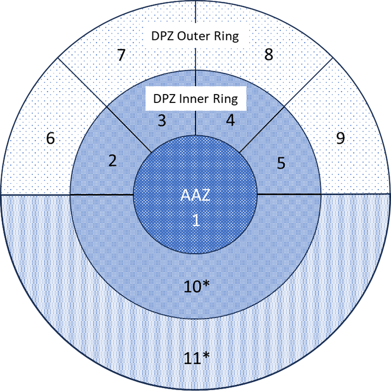
Figure M – 1 : Detailed Planning Zone and Response Sectors
(Diagrammatic - Not to Scale, * = Lake/River Sectors)
The diagram presents a circular, multi-layered structure that organizes emergency planning zones into defined response sectors. At the center is the Automatic Action Zone (AAZ 1), representing the innermost emergency planning zone. The Detailed Planning Zone (DPZ) encompasses AAZ 1. The DPZ Inner Ring is divided into five response sectors labeled 2, 3, 4, 5, and 10*. The DPZ Outer Ring encompasses the inner ring and AAZ 1 and is comprised of five additional response sectors labeled 6, 7, 8, 9, and 11*.
This diagram is for visual reference only. See the text below this figure for the full description.
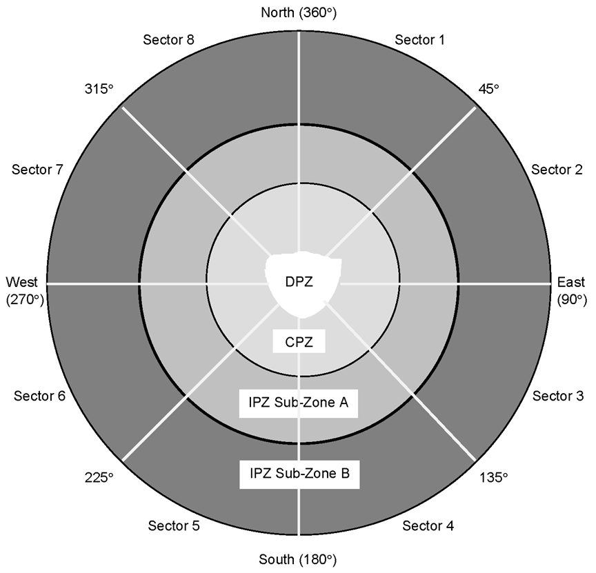

Figure M – 2 : Ingestion Planning Zones
The diagram presents a circular, multi-layered structure that illustrates the relationship between the Detailed Planning Zone (DPZ), the Contingency Planning Zone (CPZ), and the Ingestion Planning Zone (IPZ). At the center is the DPZ, surrounded by the CPZ, forming the next ring. Beyond the CPZ are two additional concentric zones: IPZ Sub Zone A (inner) and IPZ Sub Zone B (outer), each extending outward from the CPZ. The entire circular layout is divided into eight sectors, labeled Sector 1 through Sector 8, aligned with the compass directions North (360 degrees), East (90 degrees), South (180 degrees), and West (270 degrees), as well as the intermediate bearings at 45, 135, 225, and 315 degrees.
M.2 Automatic Action Zone (AAZ)
A pre-designated area immediately surrounding a reactor facility where pre-planned protective actions would be implemented on the basis of reactor facility conditions, with the aim of preventing or reducing the occurrence of severe deterministic effects.
Additional detailed planning and preparedness shall be undertaken for the AAZ to prevent or reduce deterministic effects for this zone, including the implementation of urgent protective actions (e.g., evacuation, sheltering-in-place, and ITB) during General Emergencies and some Onsite Emergencies.
M.3 Detailed Planning Zone (DPZ)
A pre-designated area surrounding a reactor facility where pre-planned protective actions are implemented as needed on the basis of reactor facility conditions, dose modelling, and environmental monitoring, with the aim of preventing or reducing the occurrence of stochastic effects (latent cancers).
Detailed planning and preparedness shall be conducted for the DPZ to ensure that protective measures can be implemented and that the associated needs and requirements of the affected public can be met.
The DPZ around a reactor facility shall be divided into response sectors. All emergency response measures, both operational and protective, shall be planned and implemented in terms of these sectors.
The desirable pattern of response sectors in a DPZ is illustrated in Figure M – 1. Response sectors lie within two rings around the reactor facility: an inner ring (which lies beyond the AAZ) and an outer ring. Within each ring, it is desirable to have as few sectors as possible while maintaining the need for flexibility and practicability in the application of the operational response strategy.
The actual demarcation of the response sector boundaries shall be such that, as far as practical, they lie along clearly recognizable features, such as roads, waterways and railway tracks. Other factors to be taken into account shall be municipal boundaries, population densities and availability of appropriate evacuation routes.
M.4 The Contingency Planning Zone (CPZ)
A pre-designated area surrounding a reactor facility, beyond the DPZ (Figure M – 2), where contingency planning and arrangements are made in advance, so that during a nuclear emergency, protective actions can be extended beyond the DPZ, as required, to reduce the potential for exposure.
Plans and arrangements for this CPZ include considerations for:
- Division into sub-zones
- Population estimates for each sub-zone
- Development of mechanisms, processes and procedures to provide for environmental radiation monitoring and data analysis by the PEOC Scientific Section
- Familiarization sessions with impacted municipalities, as required
- Identification of existing response centres that fall within the CPZ and development of a list of possible alternates located outside the CPZ
- ITB arrangements as applicable and as agreed to by relevant partner consultation
- Public awareness and education requirements consistent with Ingestion Planning Zone requirements
- No requirement for designation of additional emergency response centres (e.g., Emergency Operations Centres (EOCs), the Emergency Information Centre (EIC), reception and evacuation centres, personal monitoring and decontamination facilities, etc.) beyond those designated for the DPZ
- No additional public alerting and communications requirements beyond those established for the DPZ.
M.5 Ingestion Planning Zone (IPZ)
The IPZ is a pre-designated area surrounding a reactor facility where plans or arrangements are made to:
- Protect the food chain
- Protect drinking water supplies
- Restrict consumption and distribution of potentially contaminated produce, wild harvested foods (e.g., mushrooms and game animals) milk from grazing animals, rainwater, and animal feed
- Restrict distribution of non-food commodities until further assessments are performed.
The IPZ is divided into concentric sub-zones in order to facilitate implementation of protective measures:
- Ingestion Control Sub-Zones A and B are each divided into eight sub-zones
- Ingestion control measures are further discussed in Section L.2.3.
The divisions described above are illustrated in Figure M – 2. Actual zones and response sectors for each reactor facility shall be described in the applicable site-specific Implementing Plan.
M.6 Emergency Planning Zone distances
EPZ distances for reactor facilities are established based on a number of scientific factors including the design and number of reactors on site, and for Fermi 2, considerations for cross-border coordination. EPZ distances are determined by the application of the methodology and the details of which are found in the site-specific implementing plans. EPZ distances may vary from site to site. The radii of the EPZ surrounding each of the reactor facilities, as measured from the venting or release stacks, are detailed in the relevant site-specific implementing plans.